Sprawl and the transportation

The Urban growth story of developing nations regarding high-scale urbanization has been documented widely. The spurt in the growth of the urban cities accelerated the growth in the transportation requirements of the population. Not just transportation, the resource consumption patterns changed, and the requirements increased. The cities became a driving tool of the economies. The sprawl expanded and after the era of industrialization, engines became a driver of growth. The connection to the cities became easier and consumed lesser time as compared to the earlier modes of available transportation.  


The carbon footprint of the cities kept on expanding. As the opportunities for the urban populations expanded, incomes increased and so did the number of automobiles on the roads, another consumerism plot but more people became dependent on transportation for all kinds of work. The discourse shifted from public to private transportation systems. The discourse for the same has been shaped by the business interests, policies, and automobile manufacturing processes for the economic growth of the country. (Shin-Pei Tsay, 2013)


The spatial distribution of residential areas, workplaces, shopping malls, and other activities affected the trip distance, energy consumption, and pollutant emissions, as well as the origin-destination patterns in urban transportation. The travel distances have been increasing, and more road networks are being constructed for the movement of vehicles. In turn, the distances the cars are covering are directly increasing the owners. Somewhere owning a car has become a status symbol. (Pojani, 2018)  The improved network helped the settling of residences, industries, and commercial establishments, in cases specialized zones of activity also came up. 

Mobility crisis in cities around the world 1
Figure 2-Commuters

The vehicles on the road are becoming the cause of congestion, and unsafe traveling as accidents are on the rise and adding to the pollution-noise and air both. The quality of urban life is degrading. (Behera, 2021) On the Indian roads, one would find a bus, cars, motorbikes, rickshaws, autos, tuk-tuks, e-rickshaws, small duty trucks, and cycles (where dedicated connected pathways are missing) all fighting for space.

Mobility crisis in cities around the world 3
Figure 3-The earmarked cycling lane being used as a parking and stopping point by MT in Banglore.

To facilitate the movement of vehicles, petrol pumps came up along the roads, with the widening of streets, making the sidewalks narrower and increasing requirements of parking, on-street or multi-level (nowadays). This expansion rejected the spaces for pedestrians and cyclists, turning more people towards motorized transportation. (Shin-Pei Tsay, 2013)


The developing nations cannot look up to the policies of developed nations. There is a huge difference in socio-economic conditions, infrastructure, and administrational differences.  (Jose, 2016)


A part of it also included the policies on fuel. Fuel has been a commodity that is either taxed, to increase the price and discourage users from buying cars with higher prices on the running costs, or just to collect taxes. Or it is incentivized to make costs cheaper for the affordability of the poor. In countries such as Sri Lanka, Indonesia, Malaysia, and Turkmenistan, the prices are subsidized for the poor, but that can cause a negative impact where due to cheaper running costs, more and more people buy private vehicles. (Dr Dorina Pojani, 2021)


In the case of France, the country with the most thoughtful models for regional planning, the plans were well thought of with a holistic approach including land uses, energy consumption, and environmental, social, and economic aspects. PDUs-Urban Transport Plans are developed locally in tandem with the sectors influenced by transportation. Then comes the Urban Solidarity and Renewal Law, in which a Territorial Coherence Scheme is required.

Mobility crisis in cities around the world 5
Figure 4-Garibaldi Street in the city of Lyon.

This merges the land use, housing, transport, and commerce in a single urban planning design to prevent urban sprawl. The balance is maintained within the document in terms of urban renewal, mixed-use real estate, and preservation of the environment keeping in mind the construction and road networking. The city of Lyon implemented the plan for -a city of short distances, having the institutional and commercial centres within walking and cycling distances of the residences, with a robust network of public transport. (Mohareb E, 2016)

Mobility crisis in cities around the world 7
Figure 5-Boston cycle infrastructure.

In Brooklyn, The New York City Department used several means to get the public involved in decongesting the traffic at the Grand Army Plaza. The design modifications were implemented in a phased manner keeping in check the public involvement after every phase got completed.(Vujic, 2016) The same was helpful in the city of Boston when the bicycle director of the city encouraged public participation. The cyclist used the google maps of the city and noted their routes, the data required for the development of cycling routes in the city came through the users directly. (Pedroso, 2016) The Cycle Embassy of Denmark was the first such policy instrumented on a national level promoting cycling as a respected mode of urban transportation. (Shin-Pei Tsay, 2013)

Mobility crisis in cities around the world 9
Figure 6-Traffic congestion in the city of Johannesburg due to the use of private transportation

In the city of Johannesburg, South Africa, TOD plays an important role as it came with the transit system to meet people’s needs. The use of Rea Vaya in the city of Johannesburg has made the transport system to be close to the residential areas and recreational areas, Reya Vaya moves from Johannesburg (CBD) going to Soweto and its stations are close to the business, residential and retail. The use of Gautrain was one of the mass transit systems implemented by the Gauteng province.

Mobility crisis in cities around the world 11
Figure 7-Rea Vaya Bus Transit

Gautrain uses its lane which reduces wastage of energy and delayed travel time. The use of Neon lights on this transit system also attracts many commuters to use public transport other than private transport. This transit system is said to be one of the fastest and quickest modes of public transportation which make people arrive early to their destinations. Gautrain travels underground which reduces air and noise pollution to the people living around the city and regions. The space that was previously used as a parking lot in malls was rezoned into the Gautrain railway line and stations in the city of Johannesburg. 

Mobility crisis in cities around the world 13
Figure 8-The Gautrain transit system

Urban mobility

Factors such as density, jobs-housing distance, and transport accessibility have significantly influenced the commuter’s travel mode for the journey to work. For commuters that are living far from the transportation station, with a low degree of job-housing balance or population density, and with poor access to the station and their workplace destinations, there are high chances that they will choose to commute by motorcycle and private car, rather than using public transport.


A sustainable model is required to achieve future urban mobility. That would entail-

  • Avoiding privately owned vehicle use
  • Commuting by public transport, walking, cycling. 
  • Improving the existing technology and fuels. (Shin-Pei Tsay, 2013)


The same can be achieved through-

  • Green Mobility
  • Mass Transit System 
  • Transport Oriented Development including the Last Mile Commute 
  • Transport Demand Management 

The importance of Transit-Oriented Development in urban planning and land use management

  • It promotes higher density and provision of jobs to the people residing within those areas, which in turn increases economic productivity. 
  • The shorter commuting distances help the poor to use their transport money to buy food and clothes and pay for their accommodation rentals as some of them won’t have to use transport to go to work but can walk instead, this reduces poverty in the country as a whole, and this makes the city or region a safe, clean and healthy environment to live at
  • The urban compact development combined with good quality public transportation makes public transport affordable for every commuter. 

Gauteng Province, South Africa

In the Gauteng Province of South Africa, the government implemented public transportation mass transit systems and bus rapid transit networks to meet the needs of society and benefit low-income households by facilitating mobility to address transportation challenges and opportunities (NPC, 2013). It also aims to dissuade motorists, especially on the busiest roads leading into the inner city. According to the CoJ (2016), as the city moves logically toward compelling open transportation frameworks, cycling paths, and person-on-foot walkaways, the need for private vehicles will undoubtedly decrease.

Green Transport Strategy was launched in June 2019 in the Gauteng province, to promote a transport system that is environmentally friendly and helps to boost economic growth and create jobs. In addition, it aims to minimize the adverse impacts of transport on the environment and encourage electric vehicle use and public transport enhancement. These integration policies and strategies have been defined in all transport sector planning, policy, and strategy documents. 

Gauteng 25-year Integrated Transport Master Plan 2013

Industries require huge amounts of water for their manufacturing or functioning processes and then the waste is being dump

The 25-year Integrated Transport Master Plan (ITMP25) consists of a full implementation strategy for the transformation of the transport system in Gauteng over the next 25 years. A number of initiatives have been identified to integrate urban public transport in the Gauteng province such as:

  • integrated public transport tickets
  • integrated public transport information


National Policy of TOD, India

The Transport Oriented Development Policy released by the Government of India for the states to adopt focuses on the development around nodes of the Mass Rapid Transit System and Bus Rapid Transit network. A distance of max 1 km around the node, the station is to be considered for mixed-use development, giving walkable access to the users. In the residences, the housing of LIG/MIG has to be provided. 


The Vision of the Document Include-


  • Enable Transformation- To assist in transforming cities from private vehicle dependent to public transport-oriented development. 


  • Accessible Public transport-promoting and making it accessible, encouraging green mobility-cycling and walking, and curbing pollution at the same time. 


  • Compact Walkable communities- to create liveable and affordable communities. 
Mobility crisis in cities around the world 15
Figure 9-Principles of TOD

The Transport Oriented Development is to be notified through the master plan and local area plan before implementation, it can be implemented in phases. The guidelines state the development of the nearby regions and all the institutional setup within the accessible range of the residential units with the requirements of the intuitions calculated beforehand. 


The focus should be on walking, cycling, feeder bus services, drop-off, and then parking facilities. The document underlines Jane Jacob’s Eyes on the streets with the integration of Commercial Spaces facing towards the streets and high boundary walls also to be removed, permitting the building to come to the edge of the street. In addition to this, designated vendor spaces and open spaces have to be considered. 


In terms of parking, street parking is to be avoided and shared parking spaces during different hours of the day can be encouraged if required. Parking facilities near the stations are not to be provided, otherwise discouraged through high parking tariffs. 


Beyond the 1km range, robust connectivity of feeder bus services is to be made available and promoted. The roads are to prioritize non-motorized transport (NMT) over Motorised transport (MT), the speed of vehicles needs to be kept under check with the use of tabletop crossings, and carriageway surfaces. Facilities that promote vehicular movement are to be discouraged, such as low-density and low-rise development, petrol pumps, and multi-level parking spaces. All the development should be inclusive and accessible for people with disabilities. The implementation and coordination with all the agencies should be done by an institutionally formed entity. Until then the coordination lies with the UBLs of the region. The implementation of TOD planning has to be done in totality to prevent the development from turning into high density along the transit. (Affairs)


The document-Existing Metro Corridor Between Chattarpur and Arjangarh of Delhi Metro Phase 2, studies the feasibility of TOD on the stretch. The stations include Arjangarh, Ghitorni, Sultanpur and Chattarpur. The development around is low-density development. The distance up to 500 m is considered a walking zone and the NMT influence zones lie till 1500m. The existing site attributes are studied and Green Infrastructure corridors are proposed. The proposals include Cultural and Tourism, Commercial village, Retail, Entertainment, and Institutional characters around the stations. 

Mobility crisis in cities around the world 17
Figure 10-Scope of the study of TOD. Source 10-TOD-Study for Existing Metro Corridor between Chattarpur and Arjangarh Delhi metro project of Phase

The typical development area plan includes provision for open spaces, a proposed road network, and a green corridor, along with building blocks and a plaza. The proposed urban zone typologies are divided every 500 m to the distance of 1500m from the station. The typical land use with proposed densities and built forms for every zone has been detailed. 

Mobility crisis in cities around the world 19
Figure 11-Proposed typical Development Source 11-TOD-Study for Existing Metro Corridor between Chattarpur and Arjangarh Delhi metro project of Phase-2
Mobility crisis in cities around the world 21
Figure 12-Proposed urban Typology Source 12-TOD-Study for Existing Metro Corridor between Chattarpur and Arjangarh Delhi metro project of Phase-2

The proposal goes up to integrating urban green, urban water, urban social, utility, and transport infrastructure. The impact of development on transport and population are projected with and without TOD and with TOD 65-70% increase in population. Sustainable strategies for Water management and solid waste management also project better outcomes. The financial feasibility is also studied and projections are done in different scenarios. 


Further studies include detailing aspects related to traffic and transportation, physical and social infrastructure, urban design development codes, environment impact assessment, heritage impact assessment, and social impact assessment in coordination with TOD and its implementation. (DMRC & Capita Symonds ) 

Mobility crisis in cities around the world 23
Figure 13-Concept Masterplan Source 13-TOD-Study for Existing Metro Corridor between Chattarpur and Arjangarh Delhi metro project of Phase-2
Mobility crisis in cities around the world 25
Figure 14-3D conceptual plan Source 14-TOD-Study for Existing Metro Corridor between Chattarpur and Arjangarh Delhi metro project of Phase-2

Transportation systems have a greater impact on people’s lives, as it includes a large share of their budgets. Now after COVID, a huge shift is evident in the way humans will choose to travel in the future. The streets were deserted and public transport also suffered losses, people had to go through tragic consequences but it opened up a window for the future. The innovations have to be accelerated and the mobility visions and strategies need to be implemented to reach the ultimate goal of sustainable, resilient, and human-centric mobility systems. (François-Joseph Van Audenhove, n.d.)

References

Alberti, M. (2008). Advances in urban ecology: Integrating human and ecological processes in urban ecosystems, Springer.
                                                                                         

Adewumi, E. & Allopi, D. (2014). Critical assessment of port Elizabeth rapid transit: journal of architecture and civil engineering. 2(1). P(1-9).


Berrisford, S. (2011). Unravelling apartheid spatial planning legislation in South Africa. Urban forum. 22(3). P(247-263). Available online at https://link.springer.com/article.


CoJ, (2016). The Importance of the Green Economy, Celebrating 130 years, City of Johannesburg.


De vos J., Van acker V., & Witlox, F. (2014). The influence of attitude on transit oriented development: an explorative analysis. Transport Policy, 35.P(326-329).


Dittmar, H. & Ohland, G. (2004). The new transit town: best practices in transit oriented development. Washington. DC (google scholar).


Du plessis, DJ. (2015). Critical reflection if urban spatial planning practices and outcomes in post apartheid South Africa: urban forum. 55. P(59-68).


Ewing, R. (2017). Pedestrian and transit friendly design. Washington: DC. American planning association.


Gorkem, G., & Huseyin, C. (2016). Relationship between land use and transportation planning in the scope of smart growth city.


Nel, V. (2016). A better zoning system for South Africa? Land use policy. P(257-264).


NPC (2013). National Development Plan Vision 2030, National Planning Commission, (NPC).


Kong, W., & Pojani, D. (2017). Transit oriented street design in Beijing. Journal of urban design (google scholar).


Lall, S.V. & Henderson, J.V. & Venables, V.J. (2017). Opening doors to the world Washington DC: Worldbank. Available at https://openknowledge.worldbank.org.


Piketty, T & Goldhammer, A. (2014). Capital in the twenty-first century. Cambridge MA: the Belknap press of Harvard University press.


Petersen, R. (2010). Urban Land Use and Transportation Planning; Wuppertal Institute, GTZ.


Sideris, A.L. (2000). Transit-Oriented Development in the inner city: A Delphi survey, Journal of Public Transportation, 3(2):75-98
                                                                                                           

Wasserman, P. C. (2014). An exploration of inner city renewal through the removal of settlers way freeway in Port Elizabeth, South Africa. Doctoral dissertation. Cape Town: University of Cape Town.


Pojani, Elona & Van Acker, Veronique & Pojani, Dorina. (2018). Cars as a status symbol: Youth attitudes toward sustainable transport in a post-socialist city. Transportation Research Part F: Traffic Psychology and Behaviour. 58. 10.1016/j.trf.2018.06.003.


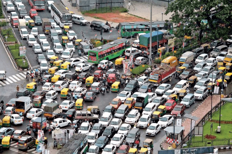
Ahmad, Sohail & Puppim de Oliveira, Jose. (2016). Determinants of urban mobility in India: Lessons for promoting sustainable and inclusive urban transportation in developing countries. Transport Policy. 10.1016/j.tranpol.2016.04.014.


Mohareb, E., Derrible, S. and Peiravian, F. (2016) Intersections of Jane Jacobs’ conditions for diversity and low-carbon urban systems: a look at four global cities. Journal of Urban Planning and Development, 142 (2). 05015004. ISSN 1943-5444


Pedroso, F. E., Angriman, F., Bellows, A. L., & Taylor, K. (2016). Bicycle use and cyclist safety following Boston’s bicycle infrastructure expansion, 2009–2012. American journal of public health, 106(12), 2171-2177.


Vujic, M. (2014). The three Cs of intensity: understanding rail-based urban assemblage in Brooklyn. WIT Transactions on Ecology and the Environment, 191, 365-377.

Affairs, M. o. (n.d.). National Transit Oriented Development (TOD) Policy. Retrieved from Ministry of Housing and Urban Affairs: https://mohua.gov.in/upload/whatsnew/59a4070e85256Transit_Oriented_Developoment_Policy.pdf


Behera, P. V. (2021, 02 16). Alternative mobility – a must have for Indian cities. Retrieved from WRI India : https://wri-india.org/blog/alternative-mobility-%E2%80%93-must-have-indian-cities


DMRC & Capita Symonds . (n.d.). Transit Oriented Development (TOD)-Study for Existing Metro Corridor Between Chattarpur and Arjangarh of Delhi Metro Project of Phase II. Retrieved from Urban Mobility India : http://urbanmobilityindia.in/Upload/Conference/434442dc-9fb7-4722-bd4d-30ead6203541.pdf


Dr Dorina Pojani, D. K. (2021). Enhancing Sustainability and Inclusiveness of Urban Passenger Transport in Asian Cities. Escap 75.


François-Joseph Van Audenhove, R. E. (n.d.). THE FUTURE OF MOBILITY POSTCOVID-19 – TURNING A CRISIS INTO AN OPPORTUNITY. Retrieved from Arthur D. Little : https://www.adlittle.com/en/insights/prism/future-mobility-postcovid-19-%E2%80%93-turning-crisis-opportunity


Shin-Pei Tsay, V. H. (2013, 07 31). Rethinking Urban Mobility: Sustainable Policies for the Century of the City. Retrieved from Carnegie Endowment for International Peace : https://carnegieendowment.org/2013/07/31/rethinking-urban-mobility-sustainable-policies-for-century-of-city-pub-52536

Saksham is a writer, researcher, architect and an editor. He is enthusiastic about the natural environment and concerned about preserving the natural essence of space. He believes that words emanating from the soul level have the potency to touch millions of others without any efforts.

Ripfumelo Meldah graduated from the University of Johannesburg with a Bachelor’s Degree in Urban and Regional Planning. She is currently pursuing her Honors. One of her skills is teamwork, and she has also allowed herself to interact spontaneously with diverse communities and people of all ages. She believes that architecture journalism is all about making a difference, not just in the field but also in the country as a whole.

Related articles

UDL Thesis Publication 2024

Curating the Best Thesis Projects Globally !

Leave a Reply

UDL Photoshop

Masterclass

Decipher the secrets of

Urban Mapping and 3D Visualisation

Session Dates

4th-5th May, 2024

Urban Design

Post-Thesis Opportunities and Resources

Join the largest social media community!

0 + K

Join Our WhatsApp Group

Recent Posts

Sign up for our Newsletter

“Let’s explore the new avenues of Urban environment together “

A Comprehensive Guide (Free E-book)

Post-Thesis Opportunities and Resources

Urban Design