hahjahanabad, the walled city area of Delhi, gives a distinct image of itself which varies across generations. For an average Delhite, this distinct image comprises mosques, temples, bazaars, havelis, katras, maze of narrow by-lanes. Evolving over centuries, the area tells many stories. In today’s times, the story being narrated is of negligence and an existing mess of choked market movement, intense commerce, a maze of dark, narrow alleyways and a great tangle of billboards and electric cables; these give identity to this area. The area is plagued with problems of trafic congestion, infrastructure deterioration, unauthorized construction, dilapidated housing conditions and conversion of residential premises to nonresidential uses. It is in need of an upgradation so as to provide a better urban environment, backed by shifting of non-conforming activities and uplifting the standards of physical and social infrastructure and revival of old glory. There is a need to evolve a strategy that will trigger off the redevelopment process and give it a new lease of life and lead the development process in continuity. The report intends to explore various aspects of the old historic core of the city in relation to the changing needs of the spaces and activities thriving in the area including mobility issues and commercial functions. This study aims at providing strategies and guidelines for urban renewal of the old city fabric to rejuvenate itself and for social and cultural life to thrive in the city. An attempt is being made to develop guidelines for regeneration of the urban fabric by a conservation approach which retains the overall character of the walled city
Site Location
Site Context:
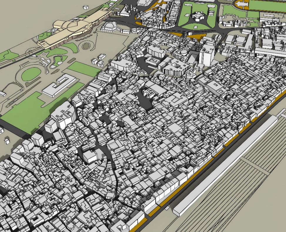
The study area stretches over 29.6 ha between Old Delhi Railway Station and Nicholson Road. The study area is well connected and, therefore, has in close proximity all the necessary amenities and facilities like schools, markets and others fulilling the daily requirements of the people. The major landmarks in the area includes Red Fort, Jama Masjid and Kashmere Gate. As per the MPD 2021 and the Zonal Plan, the area lies under Zone A and Sub zone C-1. The present predominant land use is mainly commercial consisting of wholesale trade and godowns. Due to the conlicting nature of this area being covered under a special zone, it is in need of a major overhaul in keeping with the present demand of commercial use, depleting residential density, social infrastructure and dilapidated heritage structures in the area
Site Evolution
Shahjahanabad in AD 1638
The walled city of Delhi, now known as ‘Old Delhi’ was founded in the mid-1600s by Shahjahan. The new city came to be known as Shahjahanabad, the seventh city of Delhi. The boulevard of Chandni Chowk was its commercial centrepiece, with a distinct visual character. It had shops lining it on both sides, with residences above the shops and interspersed with chowks (squares). This organic growth lent the city its character of a rich complexity of alleys, neighbourhoods and markets
Shahjahanabad in 1864
After the revolt of 1857 a major re-ordering of the physical space took place in Shahjahanabad. Subsequently both the Daryaganj and the Kashmere Gate area became the centre of administrative power during that era and many of the early colonial buildings were constructed here. The British introduced the railways in 1864 cutting through the heart of the city, not only demolishing many buildings and gardens, but cutting off the north of the city from the rest, thus changing the urban morphology of the area.
Shahjahanabad in 2014
he character of the walled city has changed over a period of several decades after Independence. One of the major changes observed is heavy commercialization, and due to its proximity to the railway station, the area’s major uses include godowns, wholesale markets etc. The Master Plan of Delhi 2021 mentions this area under a special zone, characterized by a mix of different land uses, compact built form and narrow lanes. The MPD lays greater emphasis on the area’s redevelopment.
Area Location
he area of intervention comes under ward No 77 – Kashmere Gate and ward No 80 – Chandni Chowk. It is bounded by two roads, Nicholson Road in the north and Hamilton Road to the south. These two roads connect the area to the rest of the city. Metro connectivity is provided by Kashmere Gate Metro station and Chandni Chowk Metro station. The area has in its proximity places of historic interest such as Town Hall, Dara Shikoh Library etc. This area consist of major wholesale trade of motor parts and light machines. Regional connectivity is provided by Old Delhi Railway Station with the area majorly being used for storage of goods meant for cargo. Due to the commercial nature of the area, it witnesses heavy trafic congestion. As per Master Plan of Delhi 2021, the area comes under a special zone and characterized by a mix of different land uses that have similarities in compact built form, narrow circulation space and low-rise high-density developments, mainly accommodating commercial – both retail or wholesale and industrial – as well as a small percentage of residential. The identiied uses, continue to play a major role in driving the economy of the place.
Why Revitalization?
Revitalizing: Bringing areas back to its capacity for survival or for the continuation of a meaningful or purposeful existence. In the process of revitalizing, the dynamic process must be successful to express itself in three areas:
a. Physical revitalization
b. Economic revitalization
c. Social revitalization
Physical Revitalization: In the process of revitalization, physical interventions are highly visible. This is to attract investors, visitors and residents by creating a positive image of the old historic core. Usually, in order to protect the historical fabric of the city, it is important to ensure that the historical buildings within the area are in good condition and are well maintained. Other physical interventions can either be within the existing stock of buildings, the public realm, or both. Such intervention will help to improve the external environment of a place, and thus enable an inlux of new functions and users.
Improvement in the physical and built environment of the neighbourhood through its functional and aesthetic refabrication so as to attract broader regeneration.
Preserving the area’s traditional character and promoting its architectural and cultural heritage. Acting as a catalyst for private initiatives for the rehabilitation and reuse of abandoned buildings, it can further be supported by government grants and transferable incentives.
Improving on area legibility by redesigning open public spaces (which are very limited in the area) in order to improve the quality of life and strengthen the sense of community living for local residents.
To facilitate the future development of the area as an important and lively regenerated urban centre in connection with adjacent neighbourhoods and other important social and cultural spaces like Red Fort, Chandni Chowk, Town Hall, Kashmere Gate. This can also be part of the overall plan for the revitalization of the walled city.
Economic and Functional Revitalization: Functional activities and economy are the resources to sustain the lifespan of the appearance of a historical zone. It stimulates the activities and regenerates the economy. Rehabilitation and adaptive use are vital strategies to revitalize the functional activities at historical places in the urbanspace.
Social Revitalization: A historical district should be a lively and vital place for its community and region due to its ambience, culture and dynamic activities. As the city renews itself the spatial and physical characteristics of building grain should be retained because they carry memories of our rich past. Therefore, social revitalization is needed to enhance social growth and the cultural activities in the historical core. Social revitalization reconciles the traditional activities and the contemporary lifestyle. Social revitalization manifests the habilitation approach to preserve local heritage while revitalizing the historical area.
Strategies:
By adopting plot amalgamation as one of the methods for Revitalization of urban spaces, the existing street gets widened to a minimum standard of 3.5m. The proposed width of the streets are kept in accordance with the disaster mitigation approach so as to increase the penetration of disaster management authorities, their vehicles and equipment suitable to the proposed street in event of a calamity.
The proposed plan is able to create open spaces in the area which are developed/used as the only green spaces possible in the area.
It also houses the refuge areas which act as collection points for the residents in wake of a disastrous situation so that they can be instructed and directed to the quickest evacuation route without creating any panic.
These refuge areas are otherwise used as interaction spaces/social nodes for the residents
Apart from the physical planning of the area, the residents should be made aware of the disaster mitigation techniques and drills at regular intervals through capacity building programmes to minimize casualties.
Conclusion:
The success of this Urban Regeneration project is based on the objectives and framework of the Master Plan of Delhi 2021, combined with the site speciic guidelines for this area. The overall objective of the regeneration is closely linked to the establishment of an integrated regeneration process. Central issues such as place making and the enhancement of public transport and other sustainable mobility modes can help address the issues plaguing the area. Identiication of stakeholders and implementation agencies are very important in terms of achieving structured goals. The implementation of the co-funded projects can be of more interest to private investors in this part of the walled city. Investment can be in the form of restoration of private residences, plot amalgamation, the upgrading of existing and adaptive reuse in the form of traditional craft shops, cultural centre etc. Developing a cohesive planning policy is another aspect that needs to be considered for eficient institutional tools that will help in establishing interrelationships between economic development, social inclusion and the protection of the built environment.
“Let’s explore the new avenues of Urban environment together “
We use cookies on our website to give you the most relevant experience by remembering your preferences and repeat visits. By clicking “Accept”, you consent to the use of all the cookies. Read More
This website uses cookies to improve your experience while you navigate through the website. Out of these, the cookies that are categorized as necessary are stored on your browser as they are essential for the working of basic functionalities of the website. We also use third-party cookies that help us analyze and understand how you use this website. These cookies will be stored in your browser only with your consent. You also have the option to opt-out of these cookies. But opting out of some of these cookies may affect your browsing experience.
Necessary cookies are absolutely essential for the website to function properly. These cookies ensure basic functionalities and security features of the website, anonymously.
Cookie
Duration
Description
cookielawinfo-checkbox-analytics
11 months
This cookie is set by GDPR Cookie Consent plugin. The cookie is used to store the user consent for the cookies in the category "Analytics".
cookielawinfo-checkbox-functional
11 months
The cookie is set by GDPR cookie consent to record the user consent for the cookies in the category "Functional".
cookielawinfo-checkbox-necessary
11 months
This cookie is set by GDPR Cookie Consent plugin. The cookies is used to store the user consent for the cookies in the category "Necessary".
cookielawinfo-checkbox-others
11 months
This cookie is set by GDPR Cookie Consent plugin. The cookie is used to store the user consent for the cookies in the category "Other.
cookielawinfo-checkbox-performance
11 months
This cookie is set by GDPR Cookie Consent plugin. The cookie is used to store the user consent for the cookies in the category "Performance".
viewed_cookie_policy
11 months
The cookie is set by the GDPR Cookie Consent plugin and is used to store whether or not user has consented to the use of cookies. It does not store any personal data.
Functional cookies help to perform certain functionalities like sharing the content of the website on social media platforms, collect feedbacks, and other third-party features.
Performance cookies are used to understand and analyze the key performance indexes of the website which helps in delivering a better user experience for the visitors.
Analytical cookies are used to understand how visitors interact with the website. These cookies help provide information on metrics the number of visitors, bounce rate, traffic source, etc.
Advertisement cookies are used to provide visitors with relevant ads and marketing campaigns. These cookies track visitors across websites and collect information to provide customized ads.