In his seminal work “The City Shaped,” renowned architectural historian Spiro Kostof offers a compelling exploration of urban form throughout history. This groundbreaking book, first published in 1991, examines how cities have been shaped by various forces – cultural, social, political, and economic. Kostof’s unique approach combines rigorous scholarship with accessible prose, making complex urban theories understandable to both experts and general readers alike. Through a rich tapestry of historical examples and insightful analysis, “The City Shaped” invites us to view cities not as static entities, but as dynamic organisms that evolve over time. This book review will delve into Kostof’s key arguments and assess the enduring relevance of his work in our rapidly urban
1. What is a city: Tracing the Historical Evolution of Cities:
Kostof’s book outlines this question by exploring the history of urban form and the origins of geometric and organic urban patterns. It examines when and why cities began to emerge and how their layouts have evolved. Kostof defines cities not just as physical structures but as cultural, political, and economic entities. This view breaks the monotony of classifying cities into specific types, showing that cities are complex in their growth and essence, which can be viewed as becoming a process of long term change and not as an event that has a certain time frame.
Kostof outlines some basic characteristics of cities, including:
Energized crowding of people:
This characteristic refers to the concentration of population in urban areas. It’s not just about density, but also about the dynamic interactions that occur when people live in close proximity. This “energized crowding” creates opportunities for social, economic, and cultural exchanges. It fosters innovation, specialization of labor, and the development of complex social structures. The energy of a city comes from these constant interactions, creating a buzz of activity and a sense of vitality that is unique to urban environments.
Physical circumscription:
This refers to the defined boundaries of a city, both natural and artificial. Cities are typically delineated spaces, separated from the surrounding countryside or other urban areas. Historically, this might have been in the form of city walls or natural barriers like rivers or hills. In modern times, it could be administrative boundaries, highways, or green belts. This physical definition gives a city its identity and helps in governance and planning. It also influences how the city grows and interacts with its surroundings.
Differentiation of uses:
Cities are characterized by a diversity of functions and land uses within their boundaries. This includes residential areas, commercial districts, industrial zones, public spaces, and more. The differentiation of uses is a key aspect of urban planning and zoning. It reflects the complex needs of urban populations and the way cities organize space to meet these needs efficiently. This characteristic also highlights the specialization and division of labor that occurs in urban environments, contributing to their economic productivity and social complexity.
Engagement with surrounding countryside:
Cities do not exist in isolation but have a symbiotic relationship with their hinterlands. This engagement includes economic relationships (such as trade and food supply), social connections (like migration patterns), and environmental interactions. The countryside provides resources, food, and often recreation spaces for urban dwellers. In turn, cities offer markets, services, and economic opportunities for rural areas. This interdependence shapes both the city and its surrounding regions, influencing patterns of growth, transportation networks, and economic development.
Amalgamation of people and planned structures:
This characteristic emphasizes that cities are more than just collections of buildings; they are living entities that combine human populations with the built environment. The “planned structures” refer to the intentional design and construction of urban infrastructure, buildings, and public spaces. However, the “amalgamation” suggests that cities are not solely the result of top-down planning, but also emerge from the organic interactions between people and their environment. This fusion of human activity and physical form creates the unique character of each city, reflecting its history, culture, and the aspirations of its inhabitants.
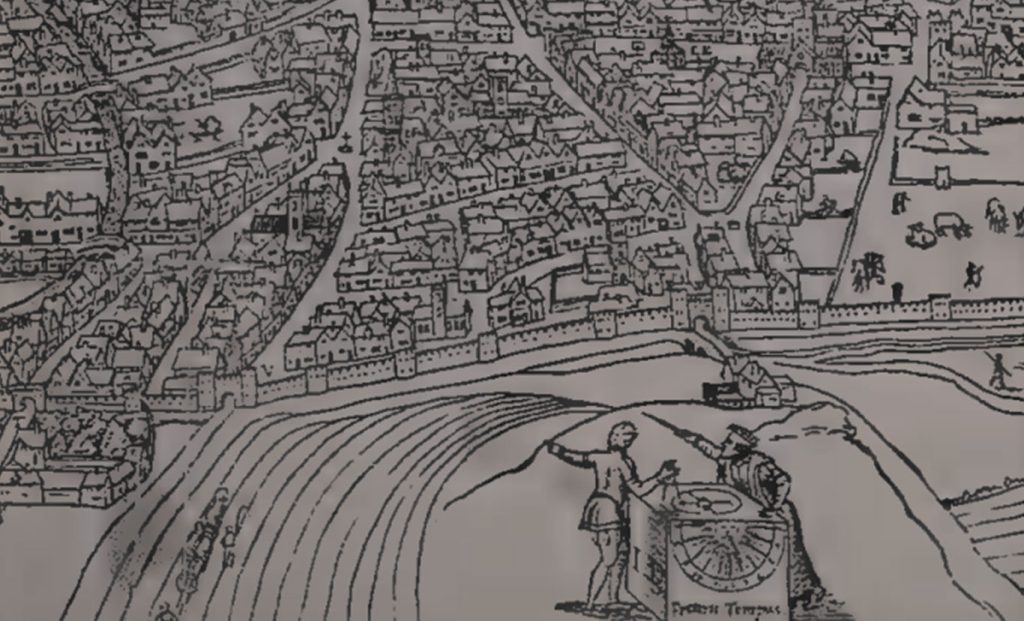
William Cunningham’s woodcut map of Norwich from “The Cosmographical Glasse” (1559).
Source: author
2. Organic Urban Fabrics: The complexity of evolving cities.
No city that is disorganized in its structure can be classified as unplanned.
Factors contributing to the development of what may be perceived as spontaneous cities include:
Topography:
The natural landscape plays a crucial role in shaping urban form. Cities adapt to their physical environment, following contours of hills, rivers, and coastlines. This adaptation can result in irregular street patterns and unique spatial arrangements that might appear unplanned but are in fact highly responsive to local geography.
Land Division Practices:
Historical methods of dividing and allocating land significantly influence urban structure. These practices, often rooted in cultural traditions or agricultural patterns, can lead to distinctive urban layouts. For example, long, narrow plots common in medieval European cities resulted in characteristic street patterns that persist today.
Administrative consolidation:
The process of merging smaller settlements or incorporating surrounding areas into a growing city can create complex urban fabrics. As different areas with their own layouts are brought together, the resulting city may appear disorganized but actually reflects a history of administrative decisions and boundary changes.
Legal systems:
Property laws, inheritance customs, and building regulations shape urban development over time. These legal frameworks influence how land is used, divided, and built upon, contributing to the organic growth of cities in ways that may not be immediately apparent but are nonetheless structured.
Economic factors:
While not explicitly mentioned in the original list, economic forces play a significant role in shaping organic urban patterns. Market demands, trade routes, and the location of resources can influence where and how development occurs, creating patterns that may seem spontaneous but are driven by economic logic.
Social and cultural practices:
Different cultural groups may have distinct preferences for spatial organization, which can lead to diverse urban patterns within a single city. Religious practices, social hierarchies, and community traditions all contribute to the organic development of urban spaces.
Organic patterns are often suitable for culturally and visually diverse urban settings. However, planned patterns should not be disagreed, as organic pattern can also represent social inequalities. Instead of perceiving a city as a model, it is necessary to consider the process of its formation based on history and culture.
Above: Nowdushan (near Yazd, Iran), Below: Machu Picchu (Peru). This image illustrates the organic urban patterns and topography.
Source: author
3. The Grid Paradigm: An Organized Urban Network
The application of grid layouts from ancient Ancient Harappan civilization, Mesopotamia and Greece through colonial settlements to modern cities demonstrates the grid’s versatility across different cultures and periods.
Use case of grid planning:
Land division and Scale – The grid system provides an efficient method for dividing land into regular, easily measurable plots. This facilitates land allocation, property management, and urban expansion. The grid’s scalability allows it to be applied to both small neighborhoods and entire cities, making it a versatile tool for planners. In ancient civilizations, the grid helped in systematic land distribution and taxation. In modern times, it simplifies zoning, infrastructure planning, and real estate development.
The equalism of society – Grid layouts can promote a sense of equality and democracy in urban spaces. By creating uniform blocks and intersections, the grid theoretically provides equal access and visibility to all parts of the city. This egalitarian aspect was particularly valued in some ancient Greek cities and during the planning of many American cities in the 18th and 19th centuries
The absolutism of an empire- Grid patterns have been used historically to assert control and impose order, reflecting the power of central authorities. This is evident in Roman colonial towns, Spanish settlements in the Americas, and 19th-century European imperial projects.
The Roman Grid (AD100): Depicting square blocks and rectilinear enclosure.
Source: author
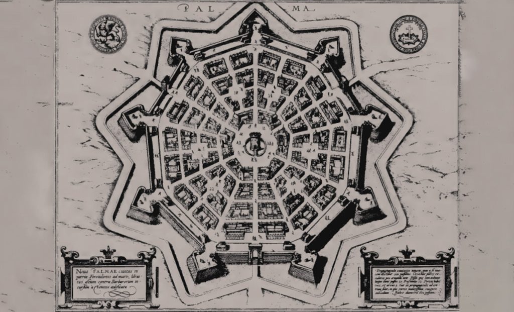
4. Abstract Concepts in City Design
Geometry and other forms of the diagram have been incorporated in the planning of cities for a long time. From the circular and the polygonal to the renaissance ideal city and beyond to present day examples. Thus, these geometric patterns may be associated with various philosophies, for instance, the concept of the cosmos order.
Examples of the cities with above mentioned city planning diagram phenomena:
Palmanova (Italy): circular and polygonal plans ideal cities.
Military camps and fortified cities: Geometric patterns for functional requirements.
Garden City concepts: Diagrammatic aspects to present the concept of an ideal city.
Soviet planned cities: Modernist planning of the urban space in socialist societies.
Baghdad (Iraq): The 8th century round plan depicting political and cosmic concepts.
Palmanova (Italy), 1593, Radial plan of Palmanova, which exemplifies the use of geometric patterns in city planning.
Source: author
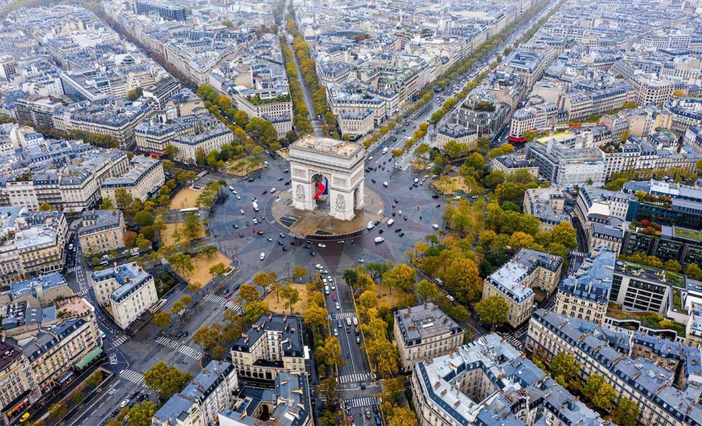
5. Monumental Urbanism: Influence of Baroque Elements on Grand City Planning
The monumental approach to planning has been employed over the centuries in order to demonstrate state authority and establish civic ethos from antiquity all the way to the Baroque period and into the contemporary world. Kostof work is mainly devoted to the European Baroque period which witnessed the growth of large scale urban design, that how Renaissance and Baroque planning used the classical tradition to transform the European capitals, opening perspectives, building wide avenues and establishing large squares.
key elements:
The use of straight streets
Diagonal avenues with star-shaped intersections
Uniform facades of the buildings
In conclusion, to comprehend the characteristics of the Grand Manner planning style, which are producing the visually impressive and integrated urban environments.
Arc de Triomphe, Paris – The course of the Champs Elysees is interrupted by a radial avenues.
‘The City Shaped’, is a beneficial and detailed analysis of the growth and formation of the urban form and its development, which recognizes cities as cultural, political, and economic manifestations. Through looking at different forms of urban organization from the organic forms and the grid systems to the diagrammatic cities and the Grand Manner that problematical for the binary division and reveals the complexity of factors that define the urban. By this, Kostof depicts how cities are not structures or constructs that are set in the particular older shape, but that are indeed processes of growth and change over time. Thus, “The City Shaped” can be considered one of the essential read that define the field of urban history and design and provide a wealth of information for architects, urban planners, and anyone interested in the development of cities.
References
Kostof, S. (1991). The City Shaped: Urban Patterns and Meanings Through History. Bulfinch Press. (Chapter 1: Organic Patterns, pp. 43-89).
Darshil Mukhtyar
About the Author
Darshil Mukhtyar is an architect and urban designer with a passion for sustainable architecture and rethinking as well as redesigning public spaces. He holds a degree in Architecture from India and a postgraduate degree in Urban Design from Sheridan College, Mississauga, Canada. His Professional interests include urban design, graphic design, 3D Modelling and visualization. In his free time, he enjoys exploring local neighborhoods, Sketching and Architectural Photography.
“Let’s explore the new avenues of Urban environment together “
We use cookies on our website to give you the most relevant experience by remembering your preferences and repeat visits. By clicking “Accept”, you consent to the use of all the cookies. Read More
This website uses cookies to improve your experience while you navigate through the website. Out of these, the cookies that are categorized as necessary are stored on your browser as they are essential for the working of basic functionalities of the website. We also use third-party cookies that help us analyze and understand how you use this website. These cookies will be stored in your browser only with your consent. You also have the option to opt-out of these cookies. But opting out of some of these cookies may affect your browsing experience.
Necessary cookies are absolutely essential for the website to function properly. These cookies ensure basic functionalities and security features of the website, anonymously.
Cookie
Duration
Description
cookielawinfo-checkbox-analytics
11 months
This cookie is set by GDPR Cookie Consent plugin. The cookie is used to store the user consent for the cookies in the category "Analytics".
cookielawinfo-checkbox-functional
11 months
The cookie is set by GDPR cookie consent to record the user consent for the cookies in the category "Functional".
cookielawinfo-checkbox-necessary
11 months
This cookie is set by GDPR Cookie Consent plugin. The cookies is used to store the user consent for the cookies in the category "Necessary".
cookielawinfo-checkbox-others
11 months
This cookie is set by GDPR Cookie Consent plugin. The cookie is used to store the user consent for the cookies in the category "Other.
cookielawinfo-checkbox-performance
11 months
This cookie is set by GDPR Cookie Consent plugin. The cookie is used to store the user consent for the cookies in the category "Performance".
viewed_cookie_policy
11 months
The cookie is set by the GDPR Cookie Consent plugin and is used to store whether or not user has consented to the use of cookies. It does not store any personal data.
Functional cookies help to perform certain functionalities like sharing the content of the website on social media platforms, collect feedbacks, and other third-party features.
Performance cookies are used to understand and analyze the key performance indexes of the website which helps in delivering a better user experience for the visitors.
Analytical cookies are used to understand how visitors interact with the website. These cookies help provide information on metrics the number of visitors, bounce rate, traffic source, etc.
Advertisement cookies are used to provide visitors with relevant ads and marketing campaigns. These cookies track visitors across websites and collect information to provide customized ads.