Sea-level rise is arguably the most obvious and immediate effect of climate change, endangering millions of residents in coastal cities. This article examines the physical and social implications of rising seas coastal flooding, erosion, land subsidence, and saltwater intrusion and discusses the new strategies cities are embracing to become more resilient.

It compares gray infrastructure (e.g., seawalls, breakwaters) with more environmentally friendly green infrastructure (e.g., wetlands, vegetated buffers), and notes a growing interest in hybrid systems that integrate ecological and engineering approaches. These solutions are valuable not only for physical defense but also for enhancing urban sustainability, water management, and public health.

Two international case studies provide examples of real-world responses. In Rotterdam, the Netherlands a city largely below sea level advanced urban planning and multipurpose water projects illustrate how climate adaptation can also enhance quality of life. In Alexandria, Egypt, cultural heritage sites like the Citadel of Qaitbay face serious threats from projected sea-level rise. Here, scientists and policymakers advocate for integrated coastal zone management and adaptive technologies.

Through these cases, the article demonstrates that proactive, place-based, and inclusive coastal planning is essential to safeguard both cultural heritage and urban infrastructure from intensifying climate risks.

Introduction

Climate change is one of the major challenges of the 21st century. Sea-level rise is one of the most concerning and costly effects of climate change. Sea-level rise has been estimated to be on average +2.6 mm and +2.9 mm per year ±0.4 mm since 1993. Global average sea-levels could rise by as much as 6 feet by 2100 [1]. A rise of only 1.6 feet by 2070 puts 150 million people globally and $35 trillion assets at risk in 20 of the world’s most vulnerable and fastest growing port cities [1].

Coastal environments are among the most intensively used regions of the Earth for supporting human population, activity, and industry. Because this intensive use tends to come at the expense of natural coastal environmental systems, driving ecological and landscape degradation or destruction, the challenge for coastal management is to sustainably balance the fundamental functional needs of human and natural coastal systems for the present and future. In management contexts, coastal resilience is now a keystone concept and fundamental to Building with Nature strategies to reduce coastal risk and environmental degradation.

Comprehensive resilient waterfront planning

Sea Level Rise Impacts on Coastal Areas

Sea-level rise has four distinct impacts on coastlines: coastal flooding, coastal erosion, land subsidence, and saltwater intrusion. These issues are already present, but Sea-level rise significantly accelerates their frequency, intensity, and long-term impacts.


  1. Coastal flooding is one of the most obvious and immediate threats. Sea-level rise will have more frequent tidal flooding, submergence of recreationally used beaches, and flooding of structures such as piers and docks. Storm surges and heavy rainfall events will become more intense, threatening homes, livings, and essential infrastructure [2,3].
  2. Coastal erosion is a severe problem too. Sea level rise speeds up shoreline loss, wearing away sand, soil, and rock away. It puts coastal development increasingly at risk of loss, often requiring costly retreat or adjustment.
  3. Land subsidence the gradual subsidence of land, contributes to these effects. Coastal cities tend to be built upon unconsolidated sediments that are very susceptible to subsidence, and sea-level rise consequently is even more calamitous regionally.
  4. Saltwater intrusion refers to seawater entering freshwater aquifers and contaminating water quality and threatening drinking water supplies. It is also capable of corroding subsurface utilities and reducing agricultural soil productivity.
Specific impacts on water, wastewater and stormwater systems.

Source: Website Link

Green Infrastructure and nature-based solutions

Green infrastructure is thoughtfully conceived networks of natural and semi-natural environment with the aim of delivering a broad range of ecosystem services and improving ecological integrity and human wellbeing (Benedict & McMahon, 2006; European Union, 2013). It incorporates forests, wetlands, green parks, urban open spaces, and rehabilitated landscapes that foster biodiversity, water purification, carbon sequestration, and temperature management (Ashley et al., 2018).


With its roots in landscape architecture and ecology, green infrastructure is now widely recognized for its multi-benefit nature (Fletcher et al., 2015; Mell et al., 2017). In coastal areas, green infrastructure plays a critical role in climate adaptation through flood risk reduction, erosion control, habitat connectivity provision, and enhanced groundwater recharge (Naumann et al., 2011; Raj et al., 2020). These characteristics are natural protection from storm surges and sea level rise.


Green infrastructure also increases social resilience by means of recreational areas, improved mental health, and encouraging inclusive urban development. It increases a more sustainable land use system by means of habitat conservation and ecological restoration (Banerjee et al., 2020; Salata & Yiannakou, 2016).


With coastal cities increasingly threatened, incorporating green infrastructure is imperative to developing long-term resilience and environmental sustainability.

Green infrastructure

Gray Infrastructure and Engineering-Based Adaptations

Traditionally, gray infrastructure such as breakwaters, seawalls, and revetments has been used to protect coastal communities and buildings from storms, waves, and erosion. These hard engineering coastal features constructed parallel or perpendicular to coastlines are constructed using a variety of designs and materials and are optimally suited in situations where space is limited in urban coasts (Bulleri & Chapman, 2010). Since they occupy a comparatively small spatial area, they are usually used in highly built-up areas.

Gray infrastructure has been studied for centuries and is associated with a high degree of engineering certainty regarding performance, durability in structure, and design standards. Despite these advantages, such structures are never fail-safe and are progressively criticized for their long-term environmental and social impacts (Vallero & Letcher, 2012; Galili et al., 2019). Over time, their presence can disrupt natural sediment transport, reduce biodiversity, and increase erosion in the surrounding region.

These have prompted hybrid and nature-based solutions that combine gray and green elements for enhancing resilience. Eco-engineering measures are more in vogue these days as alternative, sustainable responses to coastal hazards (O’Shaughnessy et al., 2020; Gittman et al., 2016).

Visual comparison of green (softer) and gray (harder) shoreline protection techniques

Case Study: Rotterdam’s Integrated Approach to Water and Climate Resilience

Rotterdam, located in the low-lying Rhine-Meuse Delta, is highly vulnerable to sea-level rise, river floods, and climate extremes because nearly 80% of the city lies below sea level (Molenaar et al., 2013). As one of the biggest port cities in the world, it is also vulnerable to cumulative exposure to climate change, aging infrastructure, and social disparity. Rotterdam has been transitioning from a traditional flood defense model to a water-sensitive urban management model since the mid-2000s, transforming water into opportunity instead of danger to enhance urban livability [5].

The city integrates climate adaptation and urbanization with multifunctional water initiatives, resilient infrastructure, and urban green space development. Climate challenges in the form of more intense rain, heatwaves, and saltwater intrusion threaten infrastructure, groundwater quality, and exposed populations most particularly in deprived areas such as Rotterdam South. Urban renewal, social cohesion, and climate resilience are thus inextricably connected to city policy.

Projects like Maasvlakte 2 (port expansion) and redeveloping derelict port areas illustrate efforts to balance economic development with ecological urban renewal. The Rotterdam path is a prime example of cross-sector water management in which inter-sector collaboration, spatial planning, and climate resilience come together to create urban resilience [6].

Port of Rotterdam map showing industrial zones vital to the city’s climate resilience and urban redevelopment strategy

Case Study: Coastal Resilience Strategies in Alexandria, Egypt

Alexandria, Egypt, a precious coastal urban and cultural city, is increasingly exposed to sea-level rise (SLR) with a maximum of 2 meters by 2100 in the worst-case climate scenario (RCP 8.5 and SSP5). This threatens precious cultural heritage like the Citadel of Qaitbay, Ras El-Tin Palace, and Bibliotheca Alexandrina Museums. The study utilized remote sensing, GIS, and SRTM DEM data to model the flood risk under different scenarios of SLR. The Citadel of Qaitbay was found to be most at risk, with up to 44% of its surface area threatened under the 2m SLR scenario. Sites like the Chatby Tombs were less hazardous but also suffered from chronic erosion and rising groundwater.

The research encourages ICZM, legal reform, and adaptive technology implementation for the preservation of cultural heritage. Active interventions, such as those currently funded by the Green Climate Fund, aim to minimize risk through infrastructure hardening and early warning systems. The conditions point to the need for proactive, multi-dimensional coastal resilience interventions in urban heritage settings [7].

Map of Alexandria archaeological study sites

Conclusion

With global warming increasing the rate of sea-level rise, coastal cities are becoming more exposed to public health, ecosystem, and infrastructure hazards. Although gray infrastructure offers temporary protection, it can be rigid and environmentally debilitating. Green infrastructure, on the other hand, has the capability of a more sustainable long-term solution to enhance biodiversity, urban livability, and resilience.

The Rotterdam and Alexandria case studies demonstrate how different kinds of risk cities are devising tailored responses. Rotterdam is an innovative city, with water management and multifunctional design used to transform flood risk into civic opportunity. Alexandria, under threat from both urban exposure and cultural heritage loss, is using remote sensing and coastal zone management to safeguard its landmarks.

These examples highlight a shift towards incorporating engineering with environmental planning. Coastal resilience is not an isolation formula, but a dynamic process based on inter-sector cooperation, long-term investment, and community engagement.

As climate risks grow, the need for adaptive, inclusive, and scalable solutions becomes greater. Cities have much to learn from global experience and deploy hybrid infrastructure strategies that strengthen their defenses, defend their cultural heritage, and build a more resilient future against rising sea levels.

References

[1] Hu, A.; Xu, Y.; Tebaldi, C.; Washington, W.M.; Ramanathan, V. Mitigation of short-lived climate pollutants slows sea-level rise. Nat. Clim. Chang. 20133, 730–734.

[2] Nicholls, R.J.; Hoozemans, F.M.J.; Marchand, M. Increasing flood risk and wetland losses due to global sea-level rise: Regional and global analyses. Glob. Environ. Chang. 19999, S69–S87.

[3] Nicholls, R.J.; Cazenave, A. Sea-level rise and its impact on coastal zones. Science 2010328, 1517–1520.

[4] Zhang, K.; Leatherman, S. Barrier Island Population along the U.S. Atlantic and Gulf Coasts. J. Coast. Res. 2011272, 356–363.

[5] Francesch-Huidobro et al., 2017.

[6] de Graaf & van der Brugge, 2010

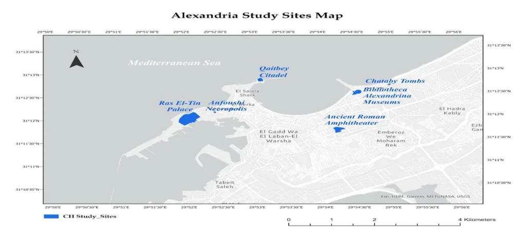
[7] Kamal, I., El-Raey, M., El-Gamily, H., & Wahab, A. (2021). Mapping the impacts of projected sea-level rise on cultural heritage sites in Egypt: Case study (Alexandria). Journal of the Faculty of Tourism and Hotels, University of Sadat City, 5(1/2), 1–20.

Mennatallah Mounir Abdelmonem Ibrahim

About the Author

Mennatallah Mounir is currently a second-year architecture student at the Faculty of Fine Arts, Helwan University. She actively investigates how smart technologies can influence future cities, having a growing interest in digital innovation and sustainable urban development. Her research focuses on combining sustainability and spatial design, with particular interest in environmental treatments that help maintain thermal comfort within designed spaces. She has worked on design projects that prioritize passive strategies, energy efficiency, and user-centered public spaces. She is enthusiastic about utilizing research to close the gap between theory and practice in urban planning and architecture.

Leave a Reply

Your email address will not be published. Required fields are marked *

This site uses Akismet to reduce spam. Learn how your comment data is processed.

Related articles

UDL Thesis Publication 2025

Call for Abstracts now open!

5-Days UDL GIS

Masterclass

GIS Made Easy – Learn to Map, Analyse, and Transform Urban Futures

Session Dates

14th-18th July 2025

Curating the best graduate thesis project globally!

Free E-Book

Spatial mapping With GIS

Map, Analyse and Transform Urban Futures !

Free E-Book

From thesis to Portfolio

A Guide to Convert Academic Work into a Professional Portfolio”

Thesis Report Writing for Architecture and Urban Studies

Join Our WhatsApp Group

Sign up for our Newsletter

“Let’s explore the new avenues of Urban environment together “

E-Book- Spatial Analysis With GIS

Map, Analyse and Transform Urban Futures!

E-Book- From Thesis To Portfolio

A Guide to Convert Academic Work into a Professional Portfolio