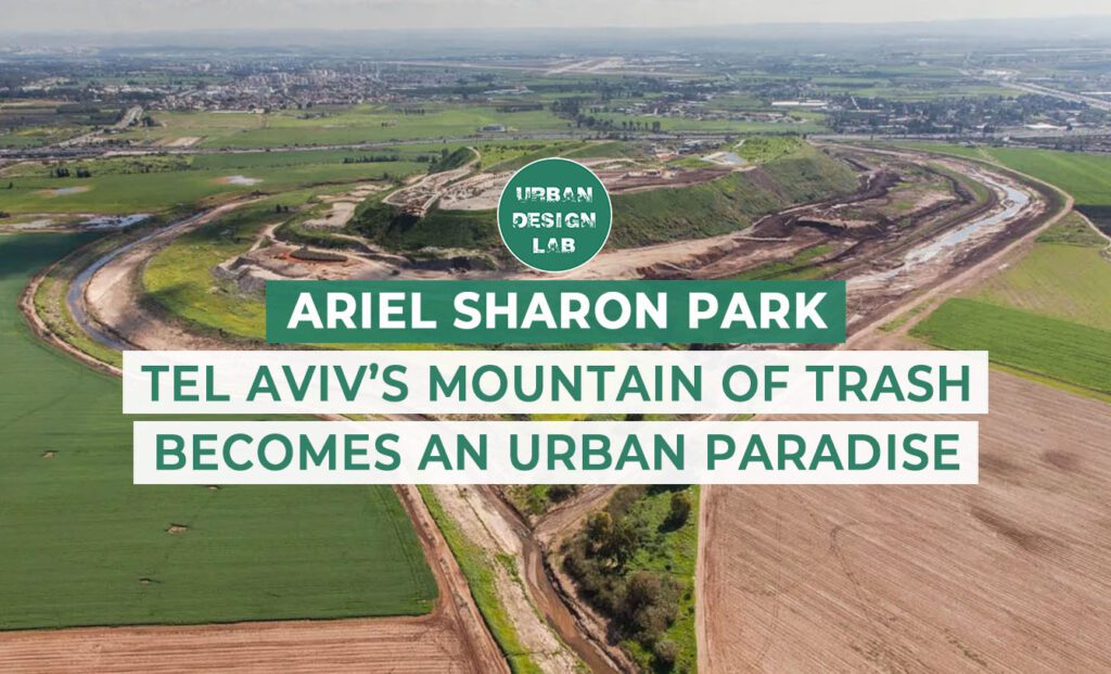
In an era of rapid urbanisation and climate change, restoring ecosystems and shaping a sustainable environment have become critical global priorities. The rehabilitation of damaged or neglected sites presents a vital opportunity to address ecological harm while supporting urban growth and sustainable development. Ariel Sharon Park, located in the southern part of Tel Aviv, is a leading example of sustainable rehabilitation. Once the site of Israel’s largest and most hazardous landfill, it has been successfully reclaimed and reimagined as a multifunctional ecological park. It now serves as a recreational hub that integrates waste recycling, biodiversity restoration, flood control, and educational functions. Through innovative design and construction, Ariel Sharon Park demonstrates how degraded land can be restored to benefit both people and nature. Its transformation offers a successful model for sustainable development and environmental regeneration, showing how even the most damaged and collapsed sites can be reimagined as active and thriving green spaces.
History: The Hiriya Landfill
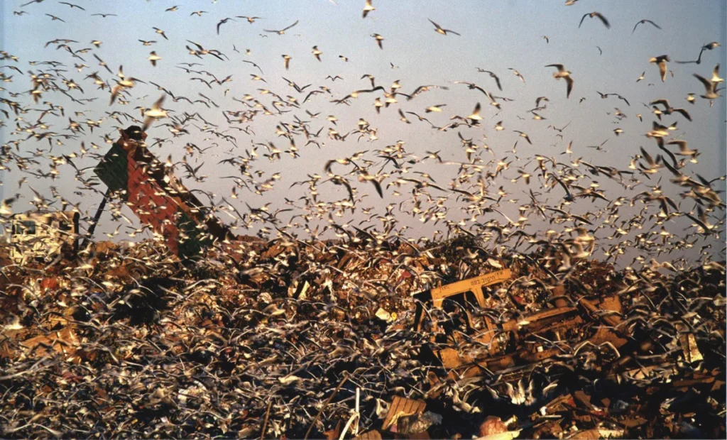
Located in the southern part of Tel Aviv, Ariel Sharon Park is one of the world’s largest and most significant landfill rehabilitation and urban regeneration projects. Before its transformation, the site was home to the Hiriya landfill, Israel’s largest waste dump from 1952 to 1998. Over decades of unregulated dumping, the landfill accumulated more than 25 million tons of waste, rising 60 meters above the surrounding area. Without proper environmental management or regulation, the site became notorious for widespread ecological hazards, including soil and water contamination, air pollution, noxious odors, and large flocks of scavenging birds that posed serious threats to air traffic at the nearby Ben Gurion Airport. Due to the immense accumulation of waste, a section of the landfill collapsed and blocked the adjacent Ayalon River between 1997 and 1998, causing severe environmental and public safety concerns. As a result, the landfill was officially closed in 1998.
After the closure of the Hiriya landfill, the Israeli government actively studied the site for potential redevelopment and environmental rehabilitation. The goal was to transform it into a positive landmark and recreational park, with a strong focus on restoring the surrounding landscape and the Ayalon River. A district plan envisioned the area as a green lung open to residents and visitors for recreational use. The government organized planning charrettes and collaborated with international experts and the Beracha Foundation, a local philanthropic organization promoting sustainability and environmental awareness, to seek innovative solutions.
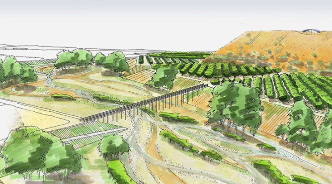
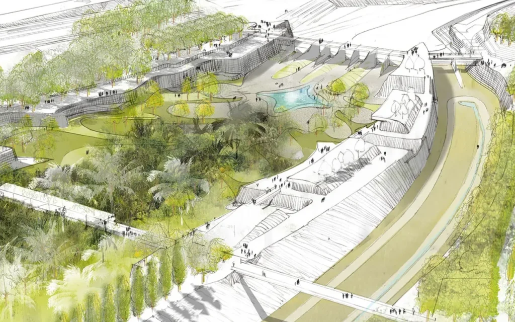
In 2004, the government launched an international design competition to develop a visionary masterplan for rehabilitation. The competition focused on restoring the landfill core, addressing instability, collapsed areas, flooding, and gas emissions. German landscape architecture firm Peter Latz + Partner, in collaboration with Moria Sekely Landscape Architects, won first prize. Their proposal embraced Hiriya’s identity as a “mystical mountain” and its history as a landfill. They introduced an innovative construction method using a bioplastic layer to block methane, topped with gravel and clean soil to protect future vegetation from contaminants.
Drawing of Peter Latz + Partner’s rehabilitation masterplan
Source: Website Link
Planning Approval and Design Development
Following the success of the initial masterplan, the Israeli government formally approved the rehabilitation plan for the Hiriya landfill in 2005. The Prime Minister emphasized the importance of completing all planning procedures before implementation. In 2009, Peter Latz + Partner led a second-phase international design competition focused on the comprehensive development of Ariel Sharon Park. The park officially opened to the public in 2011, initially with some accessible districts. It continues to be developed in phases and is still under construction, evolving with ongoing projects.
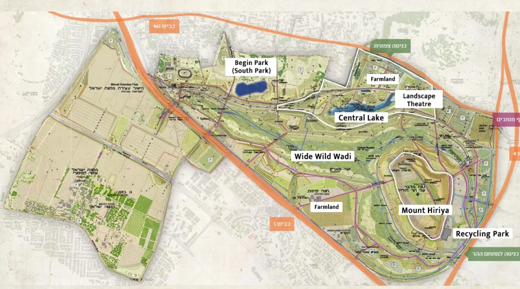
The revised plan expanded to cover 840 hectares beyond the landfill, integrating the adjacent Ayalon River floodplain, forest, and agricultural land into a large-scale ecological park. The Central Lake and Begin Park, located in the central and southern parts of the park, are designed for recreational and ecological functions. These areas provide extensive green space for walking, sports, and social activities. Near Central Lake, a landscape theatre was introduced for public events and cultural activities. By organizing such events, the park promotes environmental restoration while enhancing community engagement and awareness. Combined with the water feature, this district serves as a scenic spot for visitors and aids in water retention and flood control.
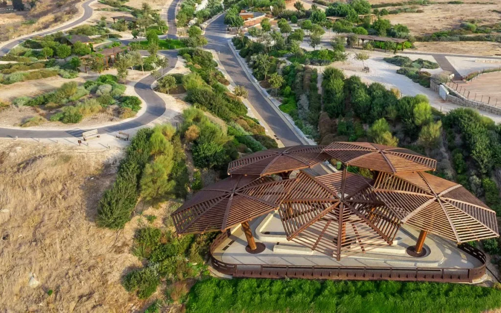
Located at the heart of Ariel Sharon Park, Mount Hiriya has been transformed into an iconic green landmark and oasis. Using millions of cubic meters of construction waste, engineers reshaped and stabilized the mountain with terraced slopes and a circular base. Hiriya Oasis features a visitor center, educational facilities, and Israel’s leading recycling park. The recycling park includes a modern waste transfer station, a Refuse-Derived Fuel (RDF) plant, and a biogas extraction system. Originally built in 2000 as a temporary solution after the landfill’s closure, the transfer station was upgraded following the opening of the RDF plant in 2016. Today, the recycling park processes up to 1,500 tons of waste per day, making it one of Israel’s largest waste treatment centers.
The Oasis also hosts school visits, guided tours, and exhibitions, making environmental education a core function. The mountain has been redesigned with landscape features, panoramic viewpoints, and shaded public areas, transforming it into a vibrant cultural venue. Large-scale public events, including the Circoloco Tel Aviv Purim Rave in 2020 and the SÜNNER Purim Party in 2025, were held at the Oasis, reinforcing its identity as a lively and sustainable public space.
Apart from its recreational and cultural functions, Ariel Sharon Park places strong emphasis on ecological restoration. The park incorporates existing farmland and agricultural areas, preserving the site’s rural character while promoting sustainable land use. A central feature of this ecological approach is the Wide Wild Wadi, a restored floodplain running through the park. It has been reimagined as a vibrant natural corridor composed of wetland habitats, forested zones, and a natural riverbed. This area not only supports flood control but also enhances biodiversity, forming the ecological heart of the park.
Another key feature is the Human Corridor, a major linear promenade running alongside the Wide Wild Wadi. It serves as the park’s connective spine, linking various districts and public zones. Integrated into the overall layout and landscape, the corridor creates recreational spaces along the riverbank. It features shaded seating, lakes, and scenic viewpoints, enabling relaxation and encouraging meaningful interaction with the natural environment. The design brings people closer to the landscape while fostering ecological awareness.
Ariel Sharon Park is a remarkable example of environmental regeneration and urban rehabilitation. Transformed from a hazardous and unused landfill into a vibrant green landmark, the site has been restored as a multifunctional ecological park. It now functions as a tourist attraction, public park, and ecological reserve, offering restored natural habitats alongside recreational and educational amenities. The design integrates landscape rehabilitation with flood control, biodiversity enhancement, and sustainable land use. Moreover, it provides diverse recreational, cultural, and educational spaces that encourage visitors to connect with nature and raise awareness about environmental issues. Large-scale events and public activities further enrich the park’s role as a social and cultural hub.
Importantly, Ariel Sharon Park connects people with the land, fostering a meaningful relationship between humans and nature. Its development strikes a balance between human use and nature conservation, avoiding over-commercialisation while offering an inclusive space that benefits both the local community and the environment. As urbanisation continues to reshape landscapes globally, the park stands as a leading example of how innovation and ecological design can reclaim degraded land. It demonstrates how ambitious restoration and ecological thinking can transform even the most damaged sites into resilient, thriving public spaces.
Latz, T. (2018). “Rehabilitation of the Hiriya Landfill, Tel Aviv”, Research for Landscape Architecture, 16(1), 54–67. https://doi.org/10.13128/RV-22991
Wing Man Chu holds an academic background in the UK, having completed a Bachelor’s degree in Geography and Urban Planning, followed by a Master’s in Urban Design and Planning. She has developed a strong foundation in sustainable development, mixed-use planning, and urban policy, with particular interests in smart cities, mobility, and sustainable design. She is passionate about delivering evidence-based, sustainability-driven solutions to the evolving challenges of contemporary cities and shaping more inclusive, resilient, and viable urban environments.
“Let’s explore the new avenues of Urban environment together “
We use cookies on our website to give you the most relevant experience by remembering your preferences and repeat visits. By clicking “Accept”, you consent to the use of all the cookies. Read More
This website uses cookies to improve your experience while you navigate through the website. Out of these, the cookies that are categorized as necessary are stored on your browser as they are essential for the working of basic functionalities of the website. We also use third-party cookies that help us analyze and understand how you use this website. These cookies will be stored in your browser only with your consent. You also have the option to opt-out of these cookies. But opting out of some of these cookies may affect your browsing experience.
Necessary cookies are absolutely essential for the website to function properly. These cookies ensure basic functionalities and security features of the website, anonymously.
Cookie
Duration
Description
cookielawinfo-checkbox-analytics
11 months
This cookie is set by GDPR Cookie Consent plugin. The cookie is used to store the user consent for the cookies in the category "Analytics".
cookielawinfo-checkbox-functional
11 months
The cookie is set by GDPR cookie consent to record the user consent for the cookies in the category "Functional".
cookielawinfo-checkbox-necessary
11 months
This cookie is set by GDPR Cookie Consent plugin. The cookies is used to store the user consent for the cookies in the category "Necessary".
cookielawinfo-checkbox-others
11 months
This cookie is set by GDPR Cookie Consent plugin. The cookie is used to store the user consent for the cookies in the category "Other.
cookielawinfo-checkbox-performance
11 months
This cookie is set by GDPR Cookie Consent plugin. The cookie is used to store the user consent for the cookies in the category "Performance".
viewed_cookie_policy
11 months
The cookie is set by the GDPR Cookie Consent plugin and is used to store whether or not user has consented to the use of cookies. It does not store any personal data.
Functional cookies help to perform certain functionalities like sharing the content of the website on social media platforms, collect feedbacks, and other third-party features.
Performance cookies are used to understand and analyze the key performance indexes of the website which helps in delivering a better user experience for the visitors.
Analytical cookies are used to understand how visitors interact with the website. These cookies help provide information on metrics the number of visitors, bounce rate, traffic source, etc.
Advertisement cookies are used to provide visitors with relevant ads and marketing campaigns. These cookies track visitors across websites and collect information to provide customized ads.