The Line—an audacious 170-kilometer linear city proposed as part of Saudi Arabia’s NEOM megaproject—represents a radical departure from conventional urban form. Promising zero emissions, car-free living, and vertical density within a narrow urban corridor, The Line challenges the concentric, polycentric, and gridded city models that have historically structured metropolitan development. Positioned as a climate-resilient, AI-powered, and hyper-efficient urban prototype, it reflects a broader global fascination with techno-futurism, post-carbon urbanism, and architectural spectacle.
Yet beneath the allure of environmental optimization and spatial efficiency lies a deeper set of contradictions: centralized control masquerading as decentralization, ecological promises predicated on massive ecological disruption, and visions of communal life embedded within a technocratic, top-down planning apparatus. The Line forces us to confront pressing questions about the future of cities: Can high-density urbanism truly be liberatory, or does it risk becoming a tool of surveillance and exclusion? Is this a viable model for climate adaptation—or a digitally cloaked exercise in authoritarian place-making?
This article critically examines The Line as both a design proposition and a socio-political artifact, unpacking its implications for urban form, governance, and human experience in an age increasingly defined by ecological precarity and digital utopianism.
The Line
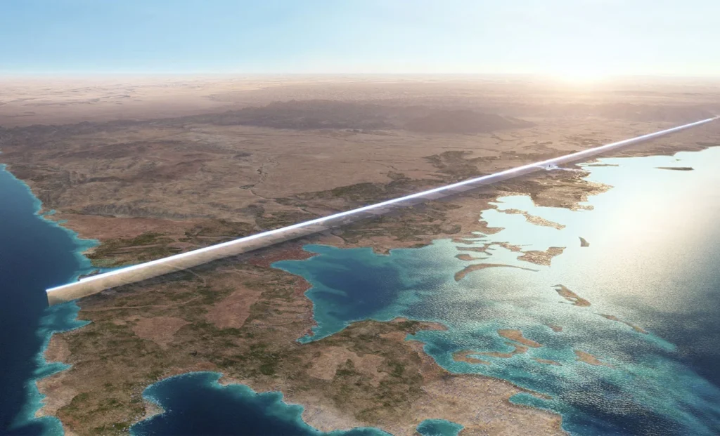
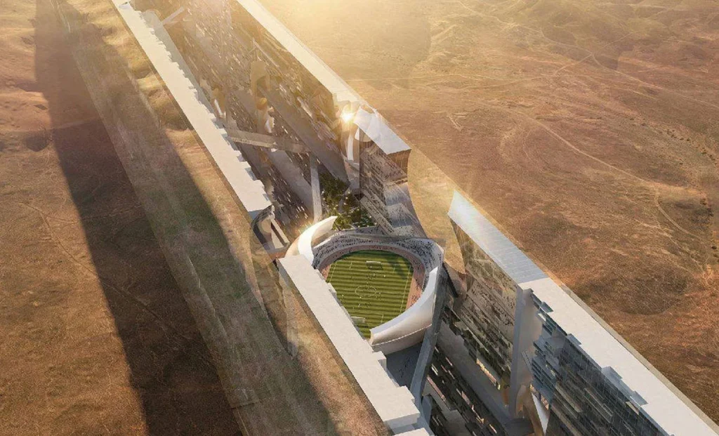
In recent years, urban planners have begun to radically rethink the shape and function of future cities. One of the most groundbreaking concepts to emerge from this shift is “The Line”. The Line is a revolutionary urban experiment being constructed in Saudi Arabia as part of the NEOM project. It stretches 170 kilometers from the Red Sea inland and aims to reimagine urban life for a post-carbon, high-density future. Launched in 2021 by Crown Prince Mohammed bin Salman, this linear city proposes to be zero-emission, car-free, and completely powered by renewable energy. With a narrow footprint and vertically layered infrastructure, it flips the logic of urban sprawl into one of compact efficiency. It is a vision not just of a futuristic city, but of a system-wide shift in how urban settlements are conceived, built, and lived in.
Key facts:
Length: 170 kilometers
Height: 500 meters above sea level
Area: 34 square kilometers
Projected population: 9 million
Travel time end to end: 20 minutes via high-speed transit
The Line introduces a fundamental shift in urban form by replacing centralized and polycentric development with a chain of modular, walkable, self-contained communities. These communities are stacked along a narrow band of land, each designed to be human-scaled and environmentally integrated. Essential services such as healthcare, education, and retail are located within a five-minute walk of any residence.Rather than expand horizontally, The Line builds vertically and connects laterally through a high-speed underground mobility network. It is designed to eliminate commutes, reduce emissions, and enable social connectivity at the neighborhood scale.
The Line Project
Source: Website Link
Location and Ecology
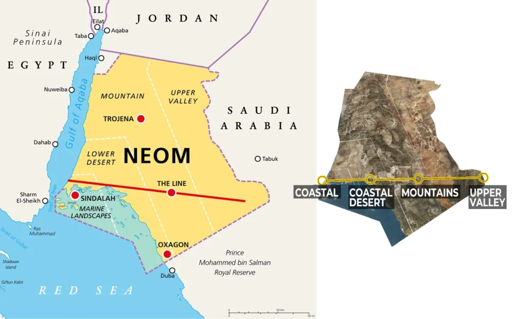
Located in northwest Saudi Arabia, The Line links the Red Sea coastline to mountain and valley terrains, intersecting four distinct ecological zones: coastal, desert, mountain, and upper valley. This diversity informs its environmental strategy, which emphasizes ecological preservation and integration.The city is being designed to conserve 95% of NEOM’s total land area, with minimal surface disruption. Its mirrored facade blends into the landscape, reducing visual and environmental impact. Passive cooling and climate-responsive design ensure walkability throughout the year.
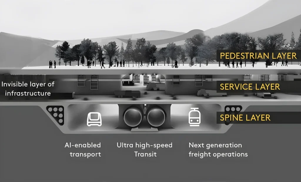
At the heart of The Line’s radical design is the concept of Zero Gravity Urbanism. The city is constructed on three vertical layers that separate urban functions to optimize space and improve livability. This structure allows communities to live, work, and access services without the need for long surface-level travel, turning verticality into a functional urban asset.
The top layer is a car-free pedestrian zone filled with public spaces and greenery
The middle layer hosts utility and service infrastructure
The bottom layer contains high-speed, autonomous mass transit systems
The Line is not only physically innovative but also digitally intelligent. It will be among the first large-scale cities to be fully cognitive, powered by artificial intelligence, low-latency networks, and predictive analytics. These systems will enable infrastructure, services, and even daily routines to adapt dynamically to the needs of residents. These technologies make The Line more than a smart city. It becomes a self-learning, self-optimizing urban ecosystem.
Over 90% of data generated within the city will be analyzed in real time
Cognitive systems will predict and respond to behavior to optimize transport, energy, and logistics
A unified digital backbone will ensure no digital divide and continuous connectivity
The Line aims to restore human-centered urban life by removing roads and private vehicles from the cityscape. Instead, it emphasizes public spaces, walkability, and mental well-being through biophilicdesign.Residents will enjoy access to parks, gardens, and cultural spaces within short walking distances. Communities are organized around plazas rather than intersections and highways. This approach not only reduces pollution but also encourages daily social interaction and active lifestyles.
As visionary as The Line is, it faces serious challenges. The technical, social, and political feasibility of such an ambitious project remains uncertain. Critics question the environmental cost of construction, the realism of attracting 9 million residents, and the ethical implications of life in an AI-managed environment.Success will depend on execution, adaptability, and the willingness of people to embrace such a radical departure from traditional city life. Whether The Line fulfills its promises or becomes a cautionary tale, it already marks a turning point in global urban thinking.
The Line stands as a bold redefinition of urban living, merging sustainability, technology, and design into a single, disruptive vision. It challenges the very foundations of how cities are structured, aiming to eliminate sprawl, reduce emissions, and prioritize human-centered spaces. While its ambitious goals come with significant challenges, The Line has already reshaped global conversations about the future of cities and what it means to live well in a rapidly changing world.
References
NEOM. (n.d.). The Line. Retrieved from https://www.neom.com/en-us
Parsons Corporation. (2023, January). THE LINE Fact Sheet.
NEOM. (n.d.). The Line: Public FAQ (English).
Albarqawi, W. (2023). The Line: A zero gravity theory for urban design. Modern Applied Science, 17(1), 18–. https://doi.org/10.5539/mas.v17n1p18
Paszkowska-Kaczmarek, N. E. (2021). The Line – The Saudi-Arabian linear city concept as the prototype of future cities. Archiwum Emigracji Architektury, 13(2), Article 03.
Tanvi Bhatia is a design professional with a background in architecture, urban design and landscape planning. She holds a Bachelor’s degree in Architecture from Manipal University Jaipur, India. Passionate about creating spaces that reflect identity and purpose, her interests include inclusive urban environments, urban mobility, sustainable materials and nature-based planning, and human-centered, research-informed spatial design.
“Let’s explore the new avenues of Urban environment together “
We use cookies on our website to give you the most relevant experience by remembering your preferences and repeat visits. By clicking “Accept”, you consent to the use of all the cookies. Read More
This website uses cookies to improve your experience while you navigate through the website. Out of these, the cookies that are categorized as necessary are stored on your browser as they are essential for the working of basic functionalities of the website. We also use third-party cookies that help us analyze and understand how you use this website. These cookies will be stored in your browser only with your consent. You also have the option to opt-out of these cookies. But opting out of some of these cookies may affect your browsing experience.
Necessary cookies are absolutely essential for the website to function properly. These cookies ensure basic functionalities and security features of the website, anonymously.
Cookie
Duration
Description
cookielawinfo-checkbox-analytics
11 months
This cookie is set by GDPR Cookie Consent plugin. The cookie is used to store the user consent for the cookies in the category "Analytics".
cookielawinfo-checkbox-functional
11 months
The cookie is set by GDPR cookie consent to record the user consent for the cookies in the category "Functional".
cookielawinfo-checkbox-necessary
11 months
This cookie is set by GDPR Cookie Consent plugin. The cookies is used to store the user consent for the cookies in the category "Necessary".
cookielawinfo-checkbox-others
11 months
This cookie is set by GDPR Cookie Consent plugin. The cookie is used to store the user consent for the cookies in the category "Other.
cookielawinfo-checkbox-performance
11 months
This cookie is set by GDPR Cookie Consent plugin. The cookie is used to store the user consent for the cookies in the category "Performance".
viewed_cookie_policy
11 months
The cookie is set by the GDPR Cookie Consent plugin and is used to store whether or not user has consented to the use of cookies. It does not store any personal data.
Functional cookies help to perform certain functionalities like sharing the content of the website on social media platforms, collect feedbacks, and other third-party features.
Performance cookies are used to understand and analyze the key performance indexes of the website which helps in delivering a better user experience for the visitors.
Analytical cookies are used to understand how visitors interact with the website. These cookies help provide information on metrics the number of visitors, bounce rate, traffic source, etc.
Advertisement cookies are used to provide visitors with relevant ads and marketing campaigns. These cookies track visitors across websites and collect information to provide customized ads.


One Comment