This article presents a detailed examination of the modeling techniques used in landscape and urban design, highlighting their varied applications and wider implications for design, communication, and environmental sustainability. It begins by outlining the value of models – physical or digital – as essential tools for spatial exploration, project verification, and stakeholder engagement across professional and community contexts. Traditional materials such as cardboard, wood, cork, and polystyrene are discussed for their tactile qualities and accessibility, alongside advanced digital technologies, particularly 3D printing, which enable high-precision and repeatable prototypes. Special focus is placed on topographic modeling and the choice of scale, both fundamental for clarity and accuracy in spatial representation. Techniques for enhancing models with color, texture, and lighting are addressed in both physical and digital forms to improve interpretability. The article also examines participatory modeling as a co-design tool, fostering dialogue and consensus, and considers environmental impacts through sustainable materials and efficient workflows. Finally, emerging frontiers such as augmented reality, virtual reality, and interactive simulations are explored. The conclusion calls for an integrated, ethical, and forward-thinking approach to modeling that supports inclusive, sustainable, and innovative transformations in both urban and landscape environments.
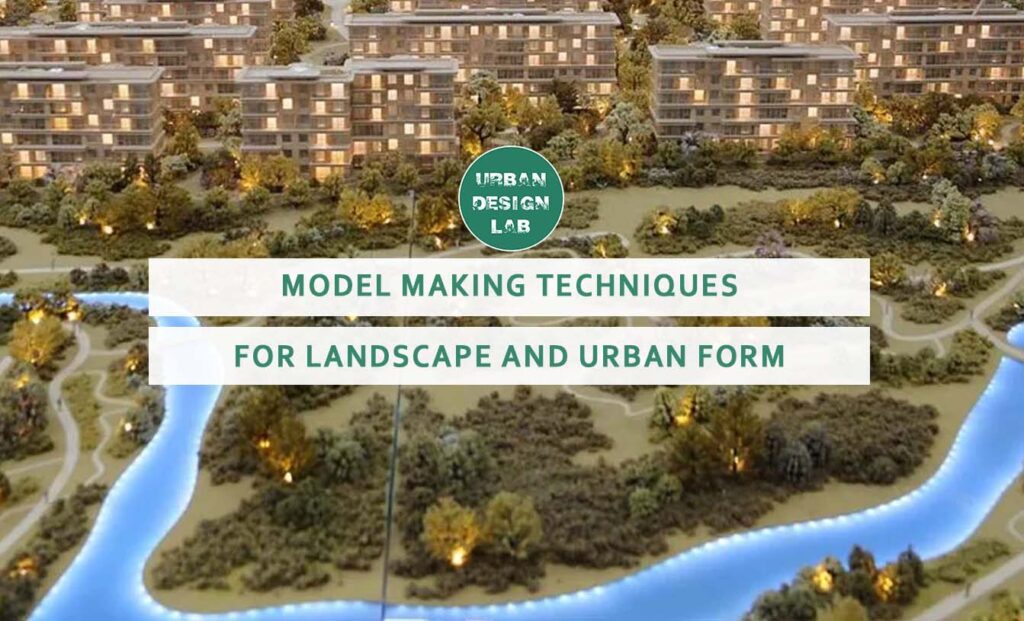
Landscape and Urban Modeling
Physical and digital modeling serves as a vital tool for exploring, analyzing, and communicating complex spatial configurations in landscape and urban design. In professional contexts such as architecture, urban planning, and environmental design, three-dimensional models provide designers with the ability to simulate relationships between built and natural environments. These models range from conceptual volumes to precise, scaled representations. Landscape modeling, in particular, allows for a nuanced visualization of topographic changes, ecological systems, and the interplay of spatial hierarchies. In urban design, physical or digital models help evaluate density, accessibility, and connectivity. The integration of traditional techniques, such as manual crafting, with advanced tools like 3D printing and augmented reality, has expanded the expressive potential of modeling. Moreover, models play a key role in participatory planning, helping bridge communication gaps between professionals, clients, and the public. They support decision-making by making invisible systems visible and comprehensible. Whether testing massing studies or environmental performance, modeling offers an invaluable layer of spatial intelligence. In today’s complex urban contexts, where sustainability, inclusivity, and adaptability are paramount, modeling is not merely a design aid – it is a critical thinking device that informs responsible and context-sensitive interventions.
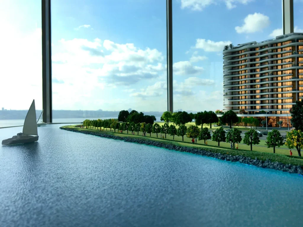
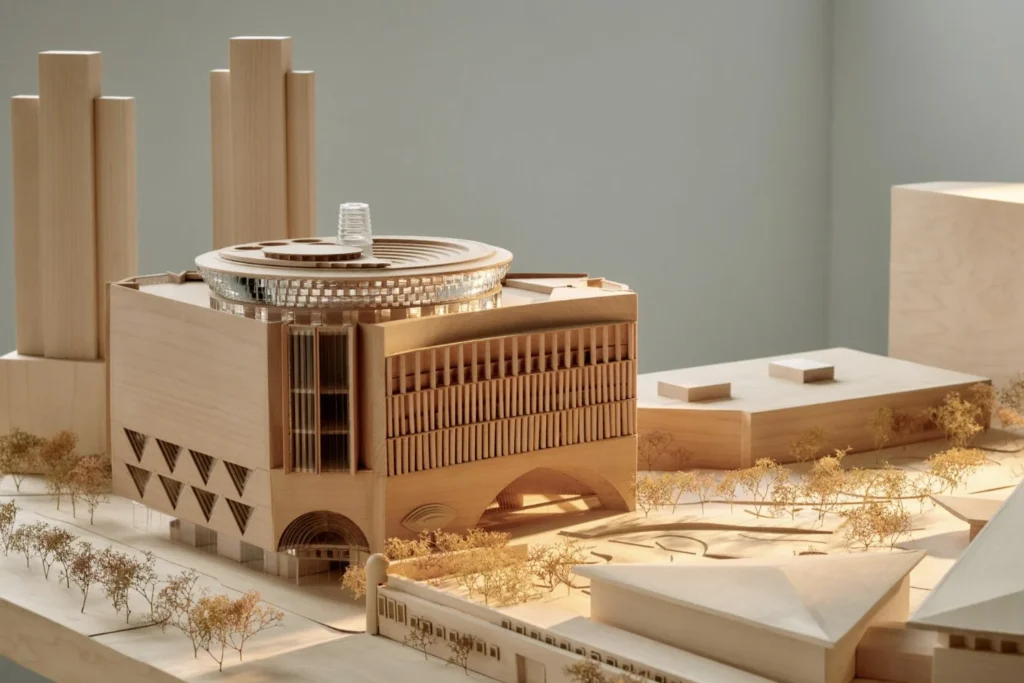
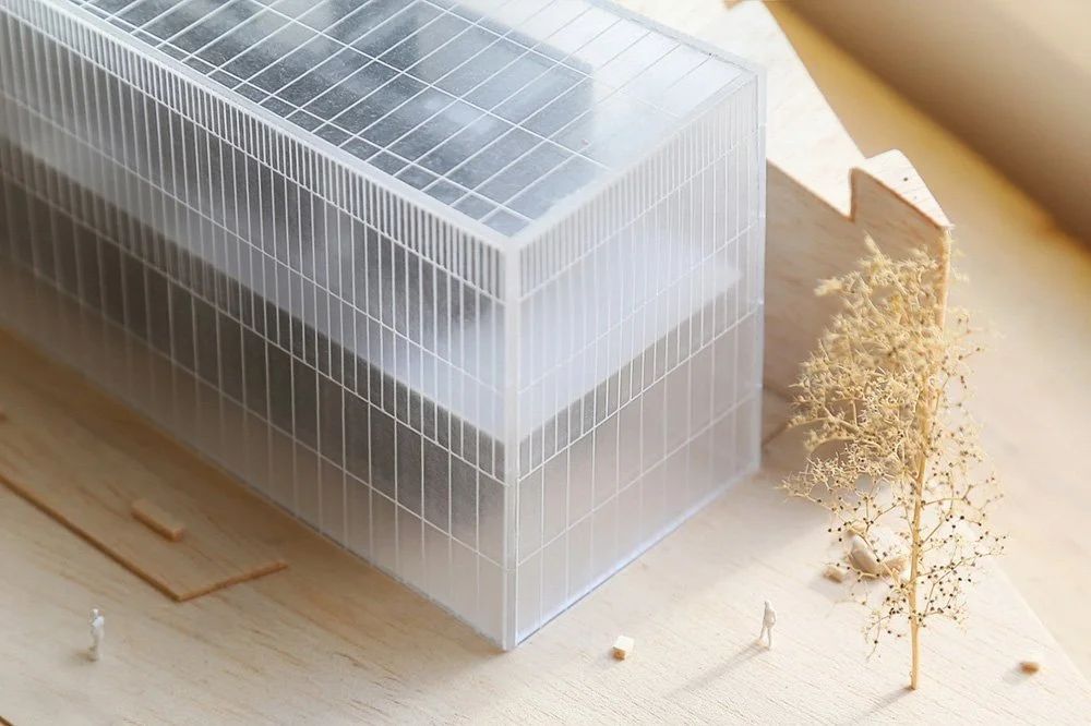
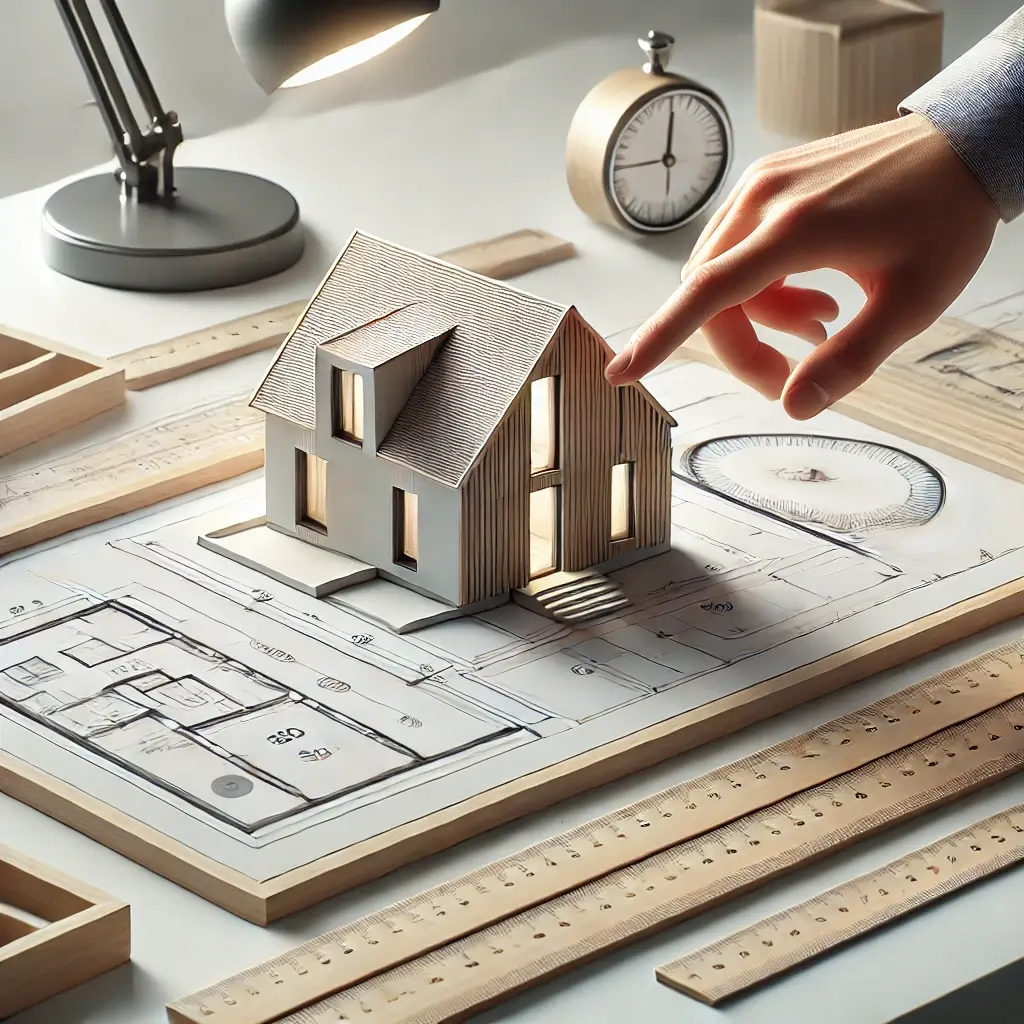
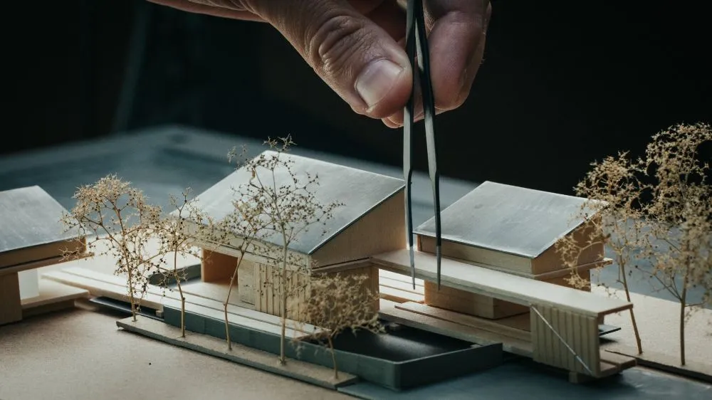
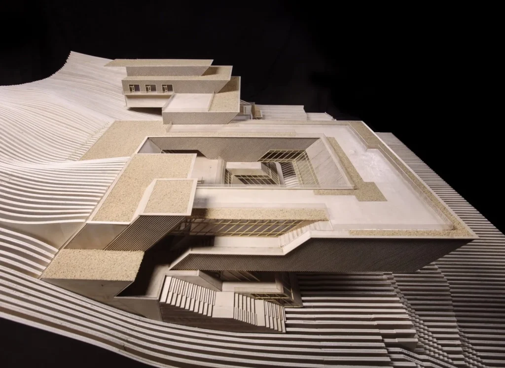
Traditional physical models are built using materials such as cardboard, balsa wood, cork, foam board, polystyrene, and acetate. These materials offer versatility, tactile richness, and ease of manipulation, making them ideal for quick conceptual mockups or more detailed architectural models. Cardboard is often chosen for massing models due to its availability and structural simplicity, while balsa wood is prized for its lightness and ease of cutting, suitable for representing fine architectural elements. Cork is commonly used to simulate terrain, thanks to its sculptable quality and natural texture. Polystyrene foam is favored for large base models and topographies, though its environmental impact is increasingly scrutinized. Acetate sheets are useful for depicting transparent surfaces such as glass or water. These materials allow designers to build spatial relationships by hand, offering a physical interaction with scale and proportion that digital tools sometimes lack. However, manual modeling also requires significant time, precision, and material waste management. The growing emphasis on sustainability is encouraging experimentation with biodegradable and recycled alternatives. Despite the rise of digital methods, traditional materials remain relevant due to their accessibility and pedagogical value. They ground abstract ideas in tangible form and offer a valuable, intuitive design experience.
Traditional materials
Source: Website Link
Digital Modeling Techniques and 3D Printing
The advent of digital modeling tools has transformed the landscape of urban and landscape representation. Software such as Rhino, SketchUp, Revit, Blender, and Grasshopper allows for the precise generation of complex geometries and interactive simulations. These tools offer real-time flexibility, enabling rapid iteration and parametric control over spatial configurations. Particularly impactful is the integration with 3D printing technologies. Digital models can be exported and materialized using additive manufacturing processes such as FDM, SLA, or SLS printing, allowing designers to produce detailed and repeatable components. Materials used in 3D printing include PLA, ABS, and resin-based composites, some of which offer environmentally conscious options. Digital fabrication bridges the gap between abstract modeling and physical prototyping, enhancing accuracy and presentation quality. It also facilitates the production of complex forms that would be difficult or time-consuming to craft by hand. However, limitations include high equipment costs, slow print times, and size constraints. Furthermore, designers must consider the environmental footprint of both the digital process and the materials used. Despite these challenges, the combination of software modeling and 3D printing enables a new level of precision, experimentation, and communication in contemporary landscape and urban design practice.
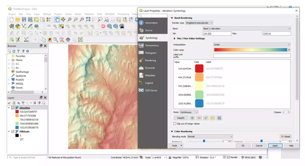
Representing terrain accurately is essential for both landscape and urban projects. The topography of a site influences layout, water drainage, visibility, infrastructure placement, and accessibility. Traditional methods include building layered contour models using stacked cardboard, cork, or foam board, which allows designers to physically express variations in elevation. These models help visualize the interaction between the built environment and natural landforms. Today, digital tools provide even more precision. GIS software, drone data, and LiDAR scanning can be used to create digital elevation models (DEMs), which are then translated into 3D surfaces using tools like Rhino Terrain, Civil 3D, or QGIS. These models can be visualized in digital environments or exported for 3D printing, providing both analytic depth and visual clarity. However, achieving balance is key: overly detailed models may become hard to interpret, while oversimplified ones may obscure essential site information. The choice of scale and level of detail depends on the model’s purpose – be it technical analysis, stakeholder communication, or design development. Ultimately, topographic modeling offers an indispensable framework for integrating ecological and infrastructural considerations into any urban or landscape intervention.
Scale and Detail: Choosing the Right Representation
Selecting the appropriate scale for a model is a critical decision that influences the model’s function, communication clarity, and material requirements. Large-scale models (e.g., 1:1000 or 1:500) are typically used for analyzing urban form, general morphology, and infrastructural layout. These scales are ideal for presenting macro-level strategies such as zoning, circulation, and density. At this level, clarity and legibility outweigh intricate detail. Intermediate scales like 1:200 or 1:100 allow for the representation of architectural features, facade treatments, and landscape patterns. They are often used in client presentations, competitions, or public exhibitions. Smaller, detailed scales such as 1:50 or 1:20 are reserved for exploring interior layouts, material junctions, and vegetation types. The chosen scale should align with the model’s purpose – whether for internal design development or public communication. Maintaining consistency between scale, materiality, and visual language ensures that the model remains effective and interpretable. Misalignment between scale and detail can compromise readability and dilute the model’s message. Therefore, modelers must critically assess their objectives, audience, and available resources when defining the most suitable scale. A well-scaled model enhances understanding, reveals spatial logic, and strengthens project communication across all stages.
The visual articulation of a model through color, texture, and lighting significantly enhances its communicative power. In physical models, selective use of color can differentiate building typologies, zoning areas, or land uses. Paints, paper overlays, and natural materials like sand or moss simulate textures and enrich tactile perception. Laser cutting or engraving can be used to imprint surfaces with detailed patterns, adding further realism. Lighting – often underestimated – plays a key role in emphasizing spatial relationships. Spotlights or LED strips can cast shadows that reveal volumes, height differences, and visual hierarchies. In digital environments, rendering tools such as Lumion, V-Ray, and Twinmotion provide highly realistic simulations. Designers can manipulate environmental factors, simulate materials, and animate movement and atmosphere. However, visual enhancement must remain functional. Overuse of decorative elements can confuse the viewer and obscure the model’s purpose. The goal is to strike a balance: visual tools should support comprehension and highlight key ideas without overwhelming the narrative. Whether physical or digital, these techniques make models more engaging, accessible, and emotionally resonant, especially for non-specialist audiences. Ultimately, effective visual communication strengthens the model’s ability to convey vision and intent with clarity.
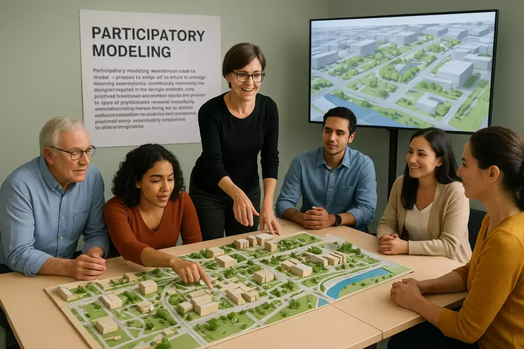
Participatory modeling involves the use of models – physical or digital – as tools for involving stakeholders, community members, and decision-makers in the design process. This collaborative approach has gained momentum in recent years, particularly in urban redevelopment, landscape restoration, and infrastructure planning. Physical models at accessible scales are often used in workshops to spark conversation, gather feedback, and visualize future scenarios. They help demystify technical concepts and make abstract proposals tangible. In digital contexts, interactive platforms allow users to explore, manipulate, and contribute to design alternatives. Tools like Unity, online 3D viewers, or AR apps enable real-time collaboration and visualization. These methods empower citizens, validate local knowledge, and build consensus around shared goals. However, successful participatory modeling requires careful facilitation. Models must be designed for clarity and inclusivity, avoiding overly technical language or inaccessible formats. Facilitators play a key role in translating between professional intentions and community priorities. When well executed, participatory modeling enhances transparency, fosters trust, and results in more contextually sensitive and widely accepted solutions. Far from being passive representations, models become active catalysts for dialogue, negotiation, and collective imagination in the shaping of urban and landscape futures.
Participatory Modeling and Co-Design
Source: author
Sustainability and Environmental Impact of Modeling
As sustainability becomes a core value in design disciplines, modeling practices are also under scrutiny for their environmental impact. Physical models often involve the use of materials like foam, plastics, or chemically treated wood, many of which are non-recyclable or non-biodegradable. The increased popularity of 3D printing has introduced additional concerns regarding energy consumption, material waste, and emissions. To address these issues, designers are exploring alternatives such as recycled cardboard, biodegradable PLA filaments, FSC-certified wood, and plant-based glues. Reusable or modular model components are also gaining traction, promoting durability and waste reduction. On the digital side, while modeling reduces material waste, it consumes electricity – especially during rendering, simulation, or cloud-based collaboration. Sustainable modeling requires a conscious balance between material choices, production methods, and long-term value. Designers must assess whether a model’s communicative and developmental benefits justify its environmental cost. Educational institutions and professional studios alike are increasingly integrating sustainability criteria into their modeling protocols. Ultimately, eco-conscious modeling supports broader goals of ethical and responsible design. It encourages innovation in both materials and methods, aligning the modeling process with the principles of circular economy and environmental stewardship.
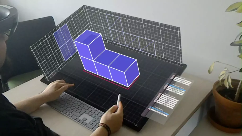
New Frontiers: Augmented Reality and Interactive Simulations
Technological innovations are rapidly expanding the frontiers of modeling, particularly through the adoption of augmented reality (AR), virtual reality (VR), and interactive simulations. AR overlays digital models onto physical spaces via smartphones or headsets, enabling users to visualize designs at full scale in real environments. VR immerses users in entirely virtual spaces, allowing for navigation, interaction, and spatial evaluation from a first-person perspective. These tools are revolutionizing design review, stakeholder engagement, and urban storytelling. Simulations can integrate real-time data such as traffic flows, environmental conditions, or population density, providing dynamic feedback and predictive modeling. Interactive models support iterative design and allow for responsive scenario testing. However, these technologies also present challenges: they require high computational power, user training, and careful curation to avoid overwhelming users with data. Their effectiveness depends on clarity, accessibility, and the ability to enhance – not replace – traditional design processes. As immersive tools become more widespread and affordable, they are poised to become standard components of urban and landscape design workflows. These new frontiers invite designers to rethink representation not as static depiction, but as an evolving, interactive dialogue between ideas, users, and environments.
Immersive 3D-Modeling Combining Augmented Reality with Interactive Displays
Modeling in landscape and urban design transcends its role as a mere representation technique. It is a strategic, communicative, and creative process that informs decision-making at every stage of design. The interplay of traditional craftsmanship and digital innovation offers a rich spectrum of possibilities – from conceptual sketches to immersive simulations. However, the true power of modeling lies in its ability to connect vision with reality. Physical and digital models serve as interfaces between ideas and their spatial implications, fostering interdisciplinary dialogue and community engagement. A conscious modeling practice considers sustainability, inclusivity, and ethical responsibility in both material choice and narrative framing. With the integration of augmented reality, real-time data, and participatory tools, models are evolving into dynamic platforms that support resilient and adaptive design thinking. As the challenges facing cities and landscapes grow more complex – climate change, social equity, resource constraints – modeling must respond with flexibility and foresight. The goal is not perfection, but relevance: models should inform better choices, spark meaningful conversations, and inspire collective imagination. In this light, modeling becomes not only a design tool, but a civic and ecological act – one that shapes the future with care, intelligence, and intent.
References
Imottesjo, H., & Kain, J.-H. (2022). The Urban CoCreation Lab—An Integrated Platform for Remote and Simultaneous Collaborative Urban Planning and Design through Web-Based Desktop 3D Modeling, Head-Mounted Virtual Reality and Mobile Augmented Reality. Applied Sciences. doi:https://doi.org/10.3390/app12020797
Ishii, H., Underkoffler, J., Chak, D., Piper, B., Eran, B.-J., Yeung, L., & Kanji, Z. (2002). Augmented Urban Planning Workbench: Overlaying Drawings, Physical Models and Digital Simulation.
United Nations Human Settlements Programme (UN-Habitat) (2019). Mixed reality for public participation in urban and public space design.
Othengrafen, F., Sievers, L., & Reinecke, E. (2023). Using augmented reality in urban planning processes. GAIA – Ecological Perspectives for Science and Society, 23, 54-63. doi:https://doi.org/10.14512/gaia.32.S1.9
The Orangery. (n.d.). In Depth Guide to Architectural Model Making. Retrieved from https://theorangeryblog.com/architecture-guides/architectural-model-making-guide
Carmela Zizzania
About the Author
Passionate about urban planning, architecture, and sustainability, she holds a Master’s degree in Building Engineering – Architecture from the University of Naples Federico II. Her academic path combines technical and design knowledge with a strong interest in urban regeneration and public space. She has conducted research on urban quality of life and sustainability, and gained experience in project development, cost estimation, urban codes, and public procurement. She is particularly interested in inclusive and resilient urban strategies, and seeks to apply interdisciplinary approaches to shape cities that are more livable, equitable, and environmentally conscious.
“Let’s explore the new avenues of Urban environment together “
We use cookies on our website to give you the most relevant experience by remembering your preferences and repeat visits. By clicking “Accept”, you consent to the use of all the cookies. Read More
This website uses cookies to improve your experience while you navigate through the website. Out of these, the cookies that are categorized as necessary are stored on your browser as they are essential for the working of basic functionalities of the website. We also use third-party cookies that help us analyze and understand how you use this website. These cookies will be stored in your browser only with your consent. You also have the option to opt-out of these cookies. But opting out of some of these cookies may affect your browsing experience.
Necessary cookies are absolutely essential for the website to function properly. These cookies ensure basic functionalities and security features of the website, anonymously.
Cookie
Duration
Description
cookielawinfo-checkbox-analytics
11 months
This cookie is set by GDPR Cookie Consent plugin. The cookie is used to store the user consent for the cookies in the category "Analytics".
cookielawinfo-checkbox-functional
11 months
The cookie is set by GDPR cookie consent to record the user consent for the cookies in the category "Functional".
cookielawinfo-checkbox-necessary
11 months
This cookie is set by GDPR Cookie Consent plugin. The cookies is used to store the user consent for the cookies in the category "Necessary".
cookielawinfo-checkbox-others
11 months
This cookie is set by GDPR Cookie Consent plugin. The cookie is used to store the user consent for the cookies in the category "Other.
cookielawinfo-checkbox-performance
11 months
This cookie is set by GDPR Cookie Consent plugin. The cookie is used to store the user consent for the cookies in the category "Performance".
viewed_cookie_policy
11 months
The cookie is set by the GDPR Cookie Consent plugin and is used to store whether or not user has consented to the use of cookies. It does not store any personal data.
Functional cookies help to perform certain functionalities like sharing the content of the website on social media platforms, collect feedbacks, and other third-party features.
Performance cookies are used to understand and analyze the key performance indexes of the website which helps in delivering a better user experience for the visitors.
Analytical cookies are used to understand how visitors interact with the website. These cookies help provide information on metrics the number of visitors, bounce rate, traffic source, etc.
Advertisement cookies are used to provide visitors with relevant ads and marketing campaigns. These cookies track visitors across websites and collect information to provide customized ads.