Digital Twins

Significant technological advancements, including the Internet of Things (IoT) and Artificial Intelligence (AI), have transformed smart cities from a mere concept into a tangible reality. At the heart of this transformation, digital twins emerge as the next frontier for futuristic urban areas. These interactive virtual replicas of cities provide real-time data utilizing sensors and geospatial data, allowing planners and officials the ability to visualize scenarios, leverage a variety of resources, and engage with citizens. Digital twins transform and improve the functionality of cities- providing a complete picture from traffic management and addressing the issues of urban heat islands and aiding in smart construction with more sustainable urban and resilient environments.

Digital Transformation of Cities: Digital Twins for Smart Urban Planning

In recent decades, tremendous advancements in computing technologies, data storage, and the Internet of Things (IoT) have transformed the concept of smart cities from science fiction into a tangible reality. At the heart of this transformation, digital twins emerge as one of the most significant innovations shaping the future of urban planning.

A digital twin is a representation of a physical object – either an entire piece of a city or a specific object larger than a rock – that can be related to a real-world entity in real-time. By connecting the physical and digital worlds, that opens up possibilities to analyze data never thought possible, monitor systems, find new opportunities, etc.

Digital twins enable a cohesive platform to integrate IoT-generated data, facilitate operational improvement, and provide decision-makers with accurate and timely insights that support smart and integrated urban development.

The image shows a digital twin reflecting real city data for smart planning.

Core Benefits of Digital Twins in Urban Design

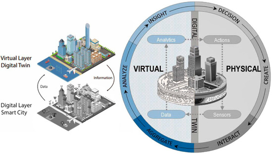
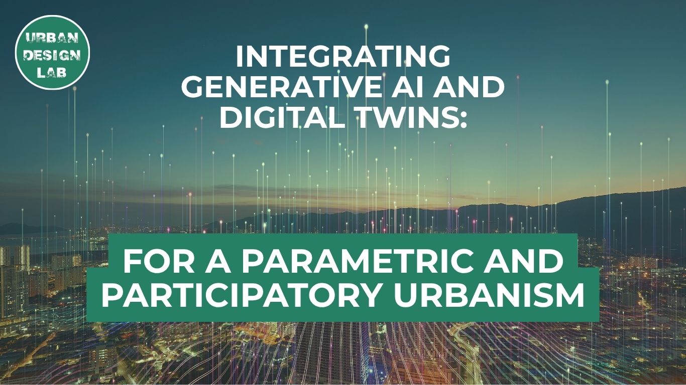
Digital twins offer a transformative suite of capabilities in contemporary urban design and planning, serving as dynamic, data-driven virtual replicas of physical urban environments.


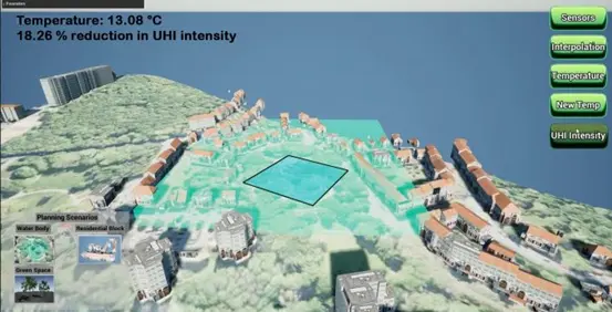
Primarily, they enhance operational efficiency by enabling the integration of real-time sensor data streams with physical infrastructure models, facilitating continuous monitoring of urban systems such as transportation, energy, water supply, and waste management. This results in improved situational awareness and optimized resource allocation.


Secondly, through predictive analytics and machine learning algorithms, digital twins support anticipatory maintenance regimes. Urban planners and engineers can model system behavior under various stress conditions, forecast component degradation, and initiate preemptive interventions, thereby minimizing service disruptions and lowering lifecycle costs.


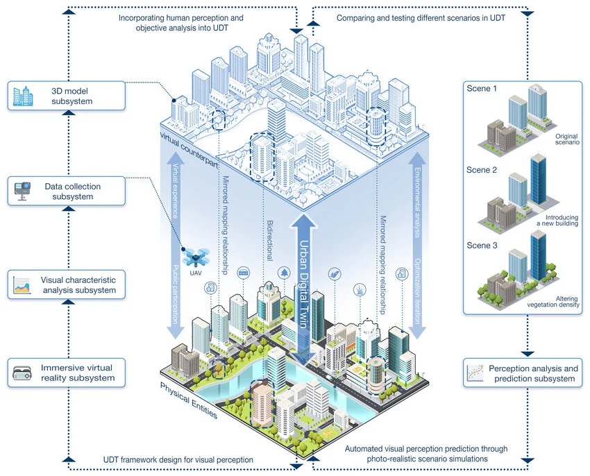
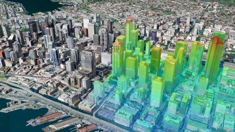
Thirdly, digital twins serve as immersive simulation environments where urban development scenarios can be virtually prototyped and iteratively tested. This enables evidence-based decision-making, improves risk assessment, and reduces the likelihood of design inefficiencies, regulatory conflicts, and construction rework.


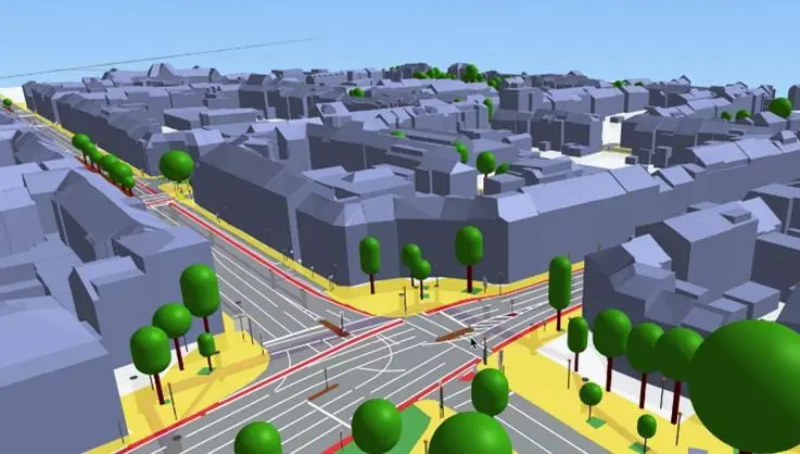
Moreover, digital twins facilitate multi-scalar stakeholder engagement by allowing policymakers, citizens, and developers to visualize the implications of planning decisions in an intuitive yet technically robust format.

Finally, by maintaining continuously synchronized datasets and enabling real-time feedback loops, digital twins support adaptive urban governance. They foster urban innovation ecosystems and significantly contribute to enhancing urban resilience, sustainability metrics, and the overall quality of urban life.

This diagram shows how Urban Digital Twins connect real and virtual city elements.

Source: Website Link

Digital Twins and Mitigating Urban Heat Islands

With urban areas continuing to expand, the need for sustainable mitigation approaches for the urban heat island (UHI) effect has become increasingly urgent. UHIs develop when cities are much warmer than nearby rural areas due to human activities and extensive/crowded construction. Digital twins are effective in addressing UHI challenges, such as, increased energy usage and lower air quality, allowing planners to test several implementation strategies to mitigate the urban heat, like, increasing green space, changing materials, and rerouting streets. Digital twins create new opportunities to engage in deliberate city modeling alongside machine learning models, that provides modelers with continued insight to consider how urban forms impact airflow and incoming solar radiation, to enable more effective planning models for climate responsive decisions.

A 3D city model with a heat map to analyze urban heat islands.

Case Study1: Enschede, Netherlands – Tackling Urban Heat

The city of Enschede, Netherlands, presents a compelling example of digital twin application for addressing urban heat island (UHI) effects. Faced with increasing urbanization and the spread of impervious surfaces, the city—in collaboration with the University of Twente—developed a detailed 3D digital twin using open-source Lidar data. This model simulated thermal comfort with a modified PET (Physiological Equivalent Temperature) metric, allowing urban planners to visualize the neighborhood-level temperature effects of changes in the built environment such as the introduction of tall buildings.. By identifying emerging hot and cool zones, the model enabled targeted interventions to mitigate predicted thermal hotspots. This project highlights the value of digital twins in enabling data-driven urban planning for climate resilience.

3D digital twin model showing UHI reduction, based on Enschede’s case study.

Case Study2: Aachen, Germany – Leading Smart Mobility

The city of Aachen, Germany, stands at the forefront of early urban digital twin adoption, with a particular focus on transport infrastructure and mobility management. Their goal is to build an integrated urban data platform and digital twin, which reaches “on, above, and below the road”  Segments of this twin were created from data collection and usage of existing urban data sources – buildings, roads, infra, underground assets even sewerage assets.


The digital twin enables streamlined construction planning, tracking of infrastructure project status, and making city development plans more tangible for citizens. It also significantly contributes to optimizing the transport network through advanced traffic simulations and predictive analysis, allowing the city to improve traffic flow and reduce congestion, thereby fostering cross-departmental cooperation within the municipal administration.

A 3D model showing Aachen’s digital twin for smart mobility management.

Challenges and Future Trends of Digital Twins

Despite their immense potential, integrating digital twins into urban planning presents several significant challenges. These include technical interoperability across heterogeneous systems—ranging from outdated legacy infrastructure to modern platforms—organizational interoperability to reduce bureaucratic friction among stakeholders, and dynamic interoperability to enable a responsive, efficient, and adaptive urban ecosystem. On top of that, cybersecurity issues are more important than ever. As we connect more systems, the potential for attacks grows, making it essential to have strong cybersecurity frameworks in place to safeguard our urban infrastructure.


Looking ahead, there are promising trends emerging: the integration of Extended Reality (XR) for immersive urban simulations, Digital Twin as a Service (DTaaS) models for greater scalability and accessibility, the adoption of 5G connectivity to enable faster and more reliable data transmission, and the combined use of cloud and edge computing to allow real-time analytics. These innovations are poised to bring digital twins to the next level as vital instruments for sustainable urban planning and smart city creation.

Diagram shows digital twin evolution with BIM, real-time data, and AI in planning.

Addressing Digital Twin Implementation Challenges

Unlocking the full potential of digital twins necessitates a proactive strategy to overcome key implementation barriers. To ensure technical interoperability, cities should adopt standardized data formats and open communication protocols, while investing in middleware solutions that seamlessly integrate legacy systems with modern technologies. Achieving organizational interoperability means developing recognizable data governance architectures that set out roles and responsibilities of stakeholders, as well as producing a data-sharing culture combined with interdepartmental cooperation. Here, the “Data Spaces Blueprint v1.0” [18] comes in handy with its recommendations.


To address cybersecurity threats, cities must develop robust security strategies encompassing encryption, access control mechanisms, and routine security audits, along with the formation of dedicated cybersecurity teams. Finally, cities are advised to begin with small-scale pilot projects, scaling gradually while emphasizing measurable outcomes and return on investment to drive wider adoption

This flowchart shows 10 steps for digital twin use and deployment success.

Conclusion

In conclusion, digital twins are transformative tools reshaping the way cities are designed, understood, and governed. By harnessing real-time data, cutting-edge simulation methods, and insights powered by AI, they empower urban planners and decision-makers to create smarter, more resilient, and community-focused urban spaces.. Their capacity to address pressing challenges—such as mitigating urban heat island effects, optimizing mobility systems, and enhancing both interdepartmental collaboration and citizen engagement—positions them as a cornerstone of sustainable urban development. As the technology matures and overcomes current implementation barriers, digital twins are poised to become embedded within the very fabric of urban life, unlocking unprecedented levels of efficiency, adaptability, and quality of life for future cities and their residents.

References

  1. (2025, January 21). Building the Future: How Digital Twins Drive Sustainable Urban Development. https://www.cebirra.id/building-the-future-how-digital-twins-drive-sustainable-urban-development/
  2. (2025, April 16). What challenges do digital twins solve? Here’s how cities benefit. https://www.cyclomedia.com/us/what-challenges-digital-twins-solve
  3. Esri Thailand. 6 Case Studies on Digital Twins. https://www.esrith.com/en/blog-en/6-case-studies-on-digital-twins/
  4. European Commission – EU Urban Mobility Observatory. (2024, November 25). Digital Twins – Lessons Learned from the City of Aachen. https://urban-mobility-observatory.transport.ec.europa.eu/resources/case-studies/digital-twins-lessons-learned-city-aachen_en
  5. GIM International. (2024, December 18). The role of digital twins in mitigating urban heat islands. https://www.gim-international.com/content/article/the-role-of-digital-twins-in-mitigating-urban-heat-islands
  6. IoT For All. (2025, January 16). Digital Twins and Smart Cities: A New Era for Urban Planning and Services. https://www.iotforall.com/digital-twins-smart-cities-urban-planning
  7. Link Digital. (2025, February 25). Data Challenges of Smart City Digital Twin Initiatives: How CKAN can help. https://linkdigital.com.au/news/2025/02/data-challenges-of-smart-city-digital-twin-initiatives-how-ckan-can-help/
  8. (2025, January 27). Top Smart Cities Trends 2025 : AI, IoT, Digital Twins, Urban, etc. https://thinkz.ai/smart-cities-trends-2025-ai-iot/
  9. Future of Digital Twins | Innovations and Impact Defined. https://www.toobler.com/blog/future-of-digital-twins
  10. UPPCS MAGAZINE. (2025, May 15). Digital Twins in Urban Planning: A Game-Changer for Smart Cities. https://uppcsmagazine.com/digital-twins-in-urban-planning-a-game-changer-for-smart-cities/

Salma Shafei Mohamed

Salma Shafei Mohamed, an architecture student interested in integrating her academic studies with contemporary issues in design and planning, aiming to deepen her understanding of architecture’s role in enhancing quality of life in communities.

Leave a Reply

Your email address will not be published. Required fields are marked *

This site uses Akismet to reduce spam. Learn how your comment data is processed.

Related articles

UDL Thesis Publication 2025

Call for Abstracts now open!

5-Days UDL GIS

Masterclass

GIS Made Easy – Learn to Map, Analyse, and Transform Urban Futures

Session Dates

14th-18th July 2025

Curating the best graduate thesis project globally!

Free E-Book

Spatial mapping With GIS

Map, Analyse and Transform Urban Futures !

Free E-Book

From thesis to Portfolio

A Guide to Convert Academic Work into a Professional Portfolio”

Thesis Report Writing for Architecture and Urban Studies

Join Our WhatsApp Group

Recent Posts

Sign up for our Newsletter

“Let’s explore the new avenues of Urban environment together “

E-Book- Spatial Analysis With GIS

Map, Analyse and Transform Urban Futures!

E-Book- From Thesis To Portfolio

A Guide to Convert Academic Work into a Professional Portfolio