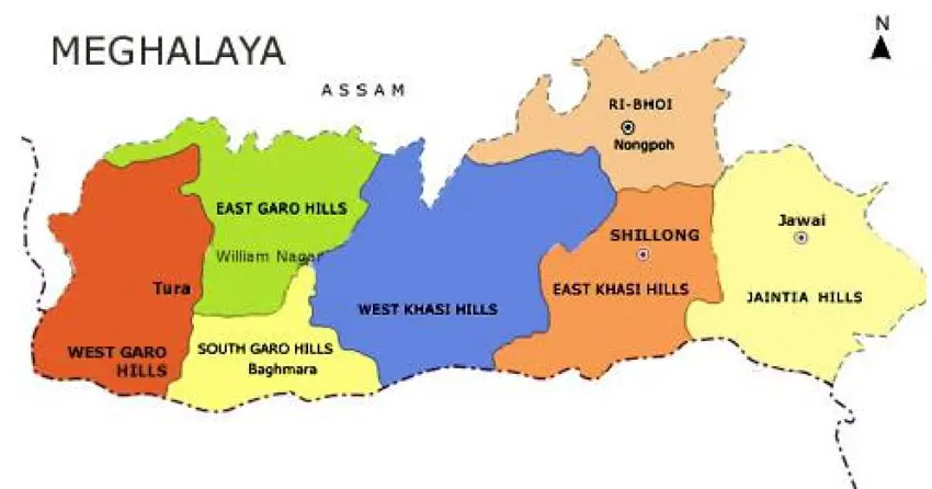
This article presents a GIS-based approach to improve climate resilience, water security, and infrastructure planning in Wahkhen, a hill village in Meghalaya’s East Khasi Hills. Although the village receives substantial rainfall, it faces recurring challenges such as slope instability, seasonal water shortages, drainage issues, and infrastructure gaps. At the same time, Wahkhen’s ecological value and cultural strength make it suitable for spatially informed rural development.
Using geospatial tools and terrain analysis, the study mapped key physical features—slope gradients, drainage lines, water bodies, and infrastructure networks. These layers informed a village-scale water budget and land suitability analysis. Planning solutions included the terrain-aligned placement of soak pits, rainwater harvesting units, greywater reuse systems, and check dams. Waste zones were defined for composting and dry waste management.
Infrastructure like roads and sanitation systems was redesigned based on slope and flow direction to reduce erosion risks. A decentralized solar microgrid was proposed to meet local energy needs. All data was integrated into a GIS dashboard to support real-time monitoring and community-based planning.
Wahkhen’s case offers a scalable model for clean, climate-adaptive village planning in similar hill regions across Northeast India.
Understanding Terrain, Water, and Vulnerability through GIS
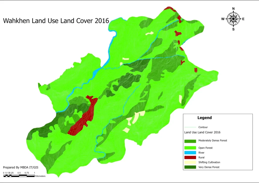
Geospatial analysis of Wahkhen village revealed that over 40% of the area lies on steep or very steep slopes, posing a high risk of landslides and rapid water runoff. By integrating rainfall data with Digital Elevation Model (DEM) analysis, natural drainage lines and flow paths were identified. These insights helped pinpoint vulnerable settlements located along runoff zones, which were prioritized for drainage improvements and flood mitigation measures. The village’s watershed boundary was also delineated to guide the placement of check dams, groundwater recharge structures, and suitable zones for cultivation. This terrain-based planning approach ensured that interventions were aligned with natural land features, minimizing environmental risk and maximizing the effectiveness of infrastructure projects. The GIS-based understanding of slope and water flow formed the foundation for all subsequent planning decisions in Wahkhen.
Lyngngai Village Layout
Source: author
Water Budgeting for a Rain-Rich but Water-Scarce Village
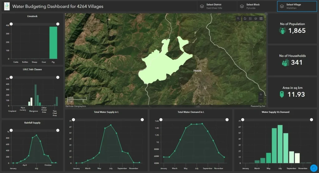
Although Wahkhen receives high annual rainfall, the village continues to face seasonal water scarcity due to rapid surface runoff, limited storage infrastructure, and declining spring sources. A detailed water budgeting exercise was carried out using geospatial tools to quantify the balance between rainfall input, runoff losses, evapotranspiration, and water demand across households, agriculture, and livestock. Monthly rainfall data was integrated with slope and land use layers derived from DEM and remote sensing to identify high-runoff zones and potential recharge sites. Rooftop rainwater harvesting was proposed as a decentralized solution to capture excess rainfall during monsoon months. Greywater from kitchens was routed to garden soak pits to support household-level reuse. Public taps were geolocated, and their distribution analyzed against household clusters and slope direction to improve accessibility. In addition, check dams and recharge pits were strategically placed in high-runoff areas to enhance groundwater infiltration. This water budgeting approach enabled evidence-based planning that optimized available water resources while reducing over-dependence on fragile spring ecosystems. The methodology can be adapted to similar hill villages facing the paradox of rainfall abundance and water scarcity.
Water budgeting dashboard showing rainfall, supply-demand gap, livestock needs, land use, and seasonal water availability for Wahkhen village.
Source: author
Designing Clean and Safe Infrastructure Aligned with Terrain
In Wahkhen, terrain-informed infrastructure planning was essential due to steep slopes, high rainfall, and fragile soils. GIS-based spatial analysis supported the redesign of key infrastructure elements, ensuring alignment with natural slope gradients and drainage patterns. Roads and footpaths were reoriented using least-cost path analysis to minimize cut-and-fill operations and reduce erosion risks. Culverts were placed along these routes to manage stormwater and prevent washouts during intense rainfall events. Soak pits were sited downslope from toilets and washing areas to prevent contamination of surface and groundwater sources.
Sanitation infrastructure, including public toilets, was located near community hubs but carefully positioned along safe drainage pathways. Compost pits and organic waste units were zoned adjacent to agricultural areas to support nutrient recycling and reduce waste transport distances. Erosion-prone areas were stabilized using vegetative buffers and stone bunds along drainage channels. Open spaces were reimagined as multifunctional landscapes—serving as community gathering zones during dry seasons and flood-buffering areas during storms.
This terrain-aligned approach ensured that infrastructure interventions were not only functionally efficient but also environmentally sustainable. It minimized long-term maintenance burdens and contributed to a cleaner, safer living environment for Wahkhen’s residents.
GIS-based infrastructure redesign: Footpaths, culverts, and sanitation units planned along slope-aligned routes to reduce erosion and enhance safety.
Source: author
Renewable Energy and Solid Waste Zones
In Wahkhen, several areas remain unconnected to the power grid, making renewable energy essential for improving energy access. Solar microgrid locations were identified using spatial analysis based on household distribution and solar exposure. Community buildings were prioritized for solar street lighting and rooftop panels to ensure basic lighting, security, and functionality.
Solid waste management was addressed through spatial zoning based on waste type. Biodegradable waste pits were located near agricultural areas to promote on-site composting and reduce waste volume. Dry waste collection centers were strategically placed near accessible roadheads to simplify collection and transport. In addition, awareness signage was installed along main footpaths to promote proper waste segregation and disposal practices.
This GIS-based zoning approach ensured a clean village environment while minimizing the transportation burden associated with waste handling. Integrating decentralized solar energy planning with targeted waste zones contributed to both environmental sustainability and improved quality of life for the residents.
Spatial zoning for decentralized solar energy and waste management in Wahkhen village: Promoting clean energy access and sustainable waste disposal.
Source: author
A Scalable GIS Framework for Village Cleanliness and Climate Planning
To facilitate integrated rural development and transparent monitoring, a GIS-based planning dashboard was created by compiling spatial layers related to water sources, toilets, roads, drainage networks, and decentralized energy systems. This platform enabled local governance institutions, such as the Dorbar Shnong, to effectively track public schemes including Jal Jeevan Mission (JJM), MGNREGA, and Swachh Bharat Mission (SBM). By visualizing infrastructure assets in one system, planners could identify spatial overlaps, reduce redundancy, and improve coordination.
Rather than relying solely on conventional planning methods, the approach combined high-resolution geospatial data with community inputs to support low-cost, terrain-responsive solutions. Interventions such as soak pits, composting units, and drainage channels were prioritized based on slope gradients, settlement clusters, and watershed boundaries. This integration of spatial intelligence with traditional village planning practices allowed for targeted, efficient, and environmentally conscious infrastructure placement.
The resulting framework offers a replicable model for other hill villages seeking clean and climate-resilient development. It demonstrates how decentralized planning, informed by GIS and rooted in community knowledge, can enhance the delivery and maintenance of essential rural infrastructure in data-scarce and ecologically sensitive regions.
Smart village planning dashboard integrating water, sanitation, energy, and drainage layers for participatory governance and scheme monitoring.
Source: author
Conclusion
This study highlights how geospatial tools can serve as powerful enablers of clean, climate-resilient village planning in ecologically sensitive regions. Through the case of Wahkhen, it becomes evident that GIS is not limited to urban-scale applications but is equally relevant for decentralized, terrain-driven rural development. By integrating slope analysis, drainage mapping, and watershed delineation, planning interventions were tailored to minimize erosion, enhance water management, and reduce environmental vulnerability.
The water budgeting approach balanced rainfall inputs with local demand across households, agriculture, and livestock, offering targeted solutions such as rooftop harvesting, recharge pits, and greywater reuse. Infrastructure design was aligned with natural terrain to ensure functional, low-maintenance systems—ranging from slope-responsive roads to sanitation units and decentralized solar grids. Solid waste and energy zones were spatially organized to reduce transport burdens and promote environmental sustainability.
All data was synthesized into a GIS dashboard, allowing the Dorbar Shnong to track schemes and guide future decisions. This village-scale, participatory model demonstrates how spatial logic, local knowledge, and digital tools can converge to build clean, adaptable, and scalable planning frameworks. It offers a replicable template for climate-responsive development in other hill settlements across Meghalaya and beyond.
References
Government of Meghalaya (2022). State Strategy for Climate Resilient Infrastructure.
NRSC (2020). Use of Remote Sensing in Watershed and Village Planning.
UN-Habitat (2021). Guidelines for Smart Villages.
FAO (2021). Rainwater Harvesting and Mountain Agro-Ecosystems.
Jana, A., & Suresh, S. (2022). GIS-based decentralized planning. Urban India.
MBDA (2022). Wahkhen Baseline Survey and Village Profile.
Dey, A. (2020). Digital Terrain Modeling in Rural India. IJRS-GIS.
SBM-G (2021). Guidelines for Rural Solid Waste Management.
Ministry of Jal Shakti (2021). JJM Implementation Manual.
Alvin Slong
About the author
Alvin Slong, is a geospatial planner from Meghalaya, working at the intersection of village-scale spatial intelligence and climate-resilient planning. He specializes in GIS-based infrastructure modeling, water budgeting, and scheme integration for decentralized development. His work draws on local ecological knowledge and government datasets to design actionable tools for rural transformation. Alvin’s approach is rooted in the ethics of participatory governance, indigenous land rights, and data sovereignty.
“Let’s explore the new avenues of Urban environment together “
We use cookies on our website to give you the most relevant experience by remembering your preferences and repeat visits. By clicking “Accept”, you consent to the use of all the cookies. Read More
This website uses cookies to improve your experience while you navigate through the website. Out of these, the cookies that are categorized as necessary are stored on your browser as they are essential for the working of basic functionalities of the website. We also use third-party cookies that help us analyze and understand how you use this website. These cookies will be stored in your browser only with your consent. You also have the option to opt-out of these cookies. But opting out of some of these cookies may affect your browsing experience.
Necessary cookies are absolutely essential for the website to function properly. These cookies ensure basic functionalities and security features of the website, anonymously.
Cookie
Duration
Description
cookielawinfo-checkbox-others
11 months
This cookie is set by GDPR Cookie Consent plugin. The cookie is used to store the user consent for the cookies in the category "Other.
cookielawinfo-checkbox-functional
11 months
The cookie is set by GDPR cookie consent to record the user consent for the cookies in the category "Functional".
cookielawinfo-checkbox-analytics
11 months
This cookie is set by GDPR Cookie Consent plugin. The cookie is used to store the user consent for the cookies in the category "Analytics".
cookielawinfo-checkbox-performance
11 months
This cookie is set by GDPR Cookie Consent plugin. The cookie is used to store the user consent for the cookies in the category "Performance".
viewed_cookie_policy
11 months
The cookie is set by the GDPR Cookie Consent plugin and is used to store whether or not user has consented to the use of cookies. It does not store any personal data.
cookielawinfo-checkbox-necessary
11 months
This cookie is set by GDPR Cookie Consent plugin. The cookies is used to store the user consent for the cookies in the category "Necessary".
Functional cookies help to perform certain functionalities like sharing the content of the website on social media platforms, collect feedbacks, and other third-party features.
Performance cookies are used to understand and analyze the key performance indexes of the website which helps in delivering a better user experience for the visitors.
Analytical cookies are used to understand how visitors interact with the website. These cookies help provide information on metrics the number of visitors, bounce rate, traffic source, etc.
Advertisement cookies are used to provide visitors with relevant ads and marketing campaigns. These cookies track visitors across websites and collect information to provide customized ads.