QGIS vs ArcGIS: Which Mapping Software is Best for Urban Planners?

Geographic Information Systems (GIS) have become critical tools in modern urban planning, helping address issues such as climate change, housing shortages, transportation equity, and evidence-based policy-making. Two platforms dominate the field: QGIS and ArcGIS. QGIS, a free and open-source solution, is valued for its flexibility, customization options, and cross-platform accessibility, making it ideal for budget-conscious organizations, academic research, and grassroots initiatives. ArcGIS, developed by Esri, offers a polished, enterprise-ready environment with advanced 3D modeling, geostatistical tools, and seamless integration across desktop, web, and mobile systems, supported by professional technical services. Cost is a major distinction: QGIS has no licensing fees, while ArcGIS requires significant investment but offers structured workflows and centralized data governance. In practice, QGIS thrives in resource-limited or experimental contexts, whereas ArcGIS is favored for large-scale, institution-led projects. Increasingly, planners adopt hybrid approaches, combining QGIS’s adaptability with ArcGIS’s stability to align with specific goals, capacities, and organizational contexts.

Introduction to Urban Planning and GIS

In the ever-evolving landscape of urban development, Geographic Information Systems (GIS) have become indispensable tools for planners striving to design cities that are not only efficient and sustainable but also resilient and inclusive. Urban planning today transcends mere zoning and land allocation; it involves addressing complex challenges such as climate change adaptation, housing shortages, transportation equity, and data-driven policy formulation. Within this intricate web of demands, GIS technology provides the analytical backbone that helps urban planners visualize, interpret, and manage spatial data with precision and foresight.

Among the suite of GIS tools available, two names dominate the conversation: QGIS and ArcGIS. QGIS, an open-source solution, is lauded for its flexibility and accessibility, while ArcGIS is known for its robust enterprise features and comprehensive toolset. Yet the question remains: which platform better serves the nuanced needs of today’s urban planners?

This article sets out to compare QGIS and ArcGIS through a detailed lens, focusing on their relevance and performance in the context of urban planning. By examining aspects such as cost, functionality, interoperability, customization, and real-world applications, we aim to provide professionals and decision-makers with a clear understanding of which tool aligns best with their strategic objectives.

What is GIS?

Overview of QGIS and ArcGIS

QGIS and ArcGIS are the leading GIS platforms used by urban planners, each offering distinct philosophies, development models, and ecosystems. Understanding these differences is crucial when selecting the right tool for planning needs.


QGIS is a free and open-source software backed by a vibrant global community of contributors and developers. First released in 2002, QGIS has evolved into a powerful, extensible platform with a modular architecture that enables users to tailor the software to specific workflows. Compatible with Windows, macOS, and Linux, QGIS is especially attractive to planners in budget-conscious settings like NGOs, academia, and local governments.


In contrast, ArcGIS—developed by Esri—is a commercial suite recognized for its polished user experience, extensive documentation, and tightly integrated tools that cover everything from 3D urban modeling to geostatistical analysis. With origins in the 1980s, ArcGIS delivers robust features such as 3D modeling and geostatistics, backed by technical support and cloud services. Though it requires a paid license, it appeals to organizations with complex, enterprise-level GIS needs.


In essence, QGIS and ArcGIS offer different paths to achieving similar planning goals. The following chapters will explore how these differences impact cost, capabilities, and real-world applications in urban planning.

Differences between QGIS and ArcGIS Pro

Source: Website Link

Cost and Accessibility

Cost is one of the most significant differences between QGIS and ArcGIS—often a deciding factor for urban planners with limited budgets. QGIS is entirely free and open-source, with no licensing fees, subscriptions, or paywalls for advanced tools. This zero-cost model makes it especially appealing to public sector institutions, grassroots organizations, and planning efforts in resource-constrained settings, including the Global South.


ArcGIS, by contrast, operates on a commercial model. Licensing ArcGIS Pro and its specialized extensions—like Spatial Analyst or 3D Analyst—can be costly. Additional fees apply for enterprise tools and cloud services such as ArcGIS Online. While Esri offers educational and government discounts, the total cost of ownership remains a key consideration.


Beyond pricing, accessibility plays a role. QGIS supports multiple operating systems and runs well on older hardware, offering greater flexibility. Its plugin-based architecture enables users to customize functionality without relying on vendor updates. ArcGIS, while more restrictive in terms of platform compatibility (primarily Windows for ArcGIS Pro), offers an integrated ecosystem that ensures consistency, especially across large organizations.


Ultimately, if affordability and adaptability are priorities, QGIS stands out. For organizations needing a polished, enterprise-ready solution with dedicated support, ArcGIS may justify its higher cost.

ArcGIS accessibility and QGIS accessibility

Functionality and Features

Both QGIS and ArcGIS offer robust tools for urban planners, but their strengths often manifest in different ways, shaped by their development models and target audiences.


ArcGIS stands out for its polished, out-of-the-box features tailored to complex planning workflows. Features like 3D city modeling, integration with Building Information Modeling (BIM), and tools for suitability analysis and land-use change prediction make it a powerful asset in large-scale urban design projects. Its close integration with ArcGIS Online allows planners to publish interactive web maps, dashboards, and apps with ease, facilitating public consultation and stakeholder engagement.


QGIS, while less uniform in interface design, is highly extensible and remarkably capable. Core functions like geoprocessing, network analysis, and raster operations are comparable to ArcGIS. For example, the QGIS Processing Toolbox aggregates tools from GRASS GIS, SAGA, and other third-party providers, offering flexibility that can sometimes surpass ArcGIS in specialized analyses. Urban planners can leverage plugins for travel-time mapping, environmental impact assessments, and real-time data integration.

In essence, both platforms meet core GIS needs. The difference lies in delivery: ArcGIS provides a streamlined, professionally supported experience; QGIS offers an open, customizable alternative better suited to flexible, hands-on planning environments.

The workflow canvas(ArcGIS) and 30 essential plugins(QGIS)

Data Integration and Interoperability

In today’s data-rich planning landscape, integrating and managing diverse datasets is a core function of any GIS platform. Urban planners routinely work with census data, traffic models, satellite imagery, and even live feeds from sensors or social media. Both QGIS and ArcGIS support broad data integration, but their approaches differ.


ArcGIS offers a unified, enterprise-ready system. Through ArcGIS Online and Enterprise, users can sync data across desktop, web, and mobile platforms. It supports numerous formats—Shapefiles, GeoJSON, BIM—and integrates with major databases and cloud services like Azure and AWS. This makes it ideal for projects requiring centralized data governance and cross-disciplinary collaboration.


QGIS, by contrast, prioritizes openness and flexibility. It handles a wide range of formats and connects easily to PostGIS, SpatiaLite, and OGC-compliant services like WMS and WFS. Its open-source nature allows deep customization, and plugins enable real-time data integration from APIs, sensors, and web services—perfect for smart city or experimental applications.


In practice, ArcGIS offers greater consistency in enterprise settings where centralized data governance is critical. QGIS excels in dynamic, multi-source contexts where rapid prototyping and adaptability are key. Understanding each platform’s data integration capabilities is crucial to matching tools with planning goals.

ArcGIS Online and the format available for QGIS

Customization and Extensibility

Urban planning is rarely one-size-fits-all—and neither are the tools that support it. Customization is crucial, especially for planners tackling innovative or non-standard projects. Both QGIS and ArcGIS offer extensibility, but in distinct ways.


QGIS is renowned for its openness and user-driven flexibility. Its modular architecture and open-source foundation allow users to modify nearly every aspect of the software. A vibrant plugin ecosystem supports specialized tasks—from participatory mapping to spatial epidemiology. For technically skilled users, the PyQGIS API enables custom tools and scripts in Python, making QGIS ideal for planners who want full control over their workflows.


ArcGIS, while more closed, provides a structured environment for customization. Using ArcPy, developers can automate processes and build custom geoprocessing tools. Esri also offers APIs for JavaScript and tools like Web AppBuilder to create tailored web applications. Though less customizable than QGIS at the user level, ArcGIS offers robust support, standardized practices, and extensive documentation—advantages for large teams needing consistency and integration with enterprise systems.


In essence, QGIS empowers hands-on experimentation and innovation, while ArcGIS supports scalable, professionally managed development. The right choice depends on the planner’s technical capacity, organizational context, and the complexity of the project at hand.

PyQGIS and ArcPy

Source: author

User Community and Support

Support structures and user communities play a crucial role in the long-term success of GIS platforms in urban planning. The availability of resources, responsiveness of support, and collaborative culture all impact how effectively planners can troubleshoot, learn, and implement solutions.


QGIS thrives on a grassroots, open-source community. Supported by a global network of developers and users, it offers extensive documentation, active forums, and peer-to-peer support on platforms like GIS Stack Exchange and GitHub. Users benefit from region-specific case studies, community-contributed plugins, and transparent development processes that foster trust and engagement.


ArcGIS, in contrast, is backed by Esri’s formal support system. Users gain access to customer service, technical hotlines, and a rich library of structured training materials, including webinars and certifications. Esri also offers in-depth training programs, certifications, and live webinars tailored for planners at all levels of expertise. For organizations that require guaranteed support and service-level agreements, this professional environment offers reliability and consistency.


ArcGIS may be more beginner-friendly due to its polished interface and guided learning. QGIS, while equally powerful, often demands more self-directed learning. Ultimately, QGIS appeals to those who value openness and collaboration, while ArcGIS suits users prioritizing structured support and institutional dependability.

QGIS Community(Facebook) and Esri Community(Esri portal)

Real-World Applications in Urban Planning

The real measure of a GIS platform is its performance in urban planning practice. Both QGIS and ArcGIS have been successfully applied in diverse contexts—from major cities to small municipalities—supporting efforts in zoning, transportation and climate resilience.


ArcGIS is widely used in large-scale, institution-led initiatives. Cities like New York, London, and Singapore employ it for comprehensive urban analytics. Singapore’s Urban Redevelopment Authority leverages ArcGIS Online to coordinate long-term urban growth by integrating 3D models with zoning data, transportation plans, and demographic trends to design new districts.


QGIS, by contrast, excels in grassroots, academic, and resource-limited settings. In Brazil, QGIS is widely used by municipal planning offices due to its cost-free accessibility. In Nairobi, community-based mapping initiatives rely on QGIS to identify informal settlements and support equitable infrastructure development.


Hybrid workflows are also common. Some agencies use ArcGIS for enterprise-level data management while relying on QGIS for rapid prototyping, fieldwork, or community outreach. Interoperable formats like GeoJSON and Shapefiles make switching between platforms seamless.


Above all, both tools are proven assets. The better choice depends not on capability, but on context—budget, scale, technical expertise, and planning objectives.

The 3D digital model of Singapore provided by the Urban Redevelopment Authority (URA).

Conclusion

Choosing between QGIS and ArcGIS depends on the specific needs, resources, and priorities of each planning context. Both platforms support advanced urban analysis, modeling, and collaboration—but serve different user profiles and institutional settings.


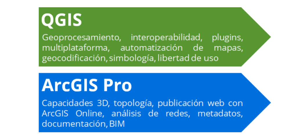
QGIS offers a flexible, cost-effective solution ideal for smaller municipalities, NGOs, academia, and international development work. Its open-source nature encourages experimentation, customization, and community-driven innovation. For planners who value adaptability, transparency, and affordability, QGIS is a powerful ally.


ArcGIS delivers a polished, enterprise-grade experience backed by technical support, training, and seamless integration across desktop, web, and mobile platforms. For organizations with the budget and need for professional-grade reliability, ArcGIS offers the advanced spatial analytics and consistency that make it well-suited for large-scale projects with institutional backing and complex requirements.

In practice, many planning teams benefit from a hybrid approach—using QGIS for rapid prototyping, data exploration, or fieldwork, while relying on ArcGIS for managing long-term, centralized geospatial infrastructure.


Eventually, whether driven by openness or operational scale, the decision should align with technical capacity, project goals, and the communities being served. Both QGIS and ArcGIS can transform urban planning—what matters most is how and where they are applied.

References

  1. Rosas-Chavoya, M., Gallardo-Salazar, J. L., López-Serrano, P. M., Alcántara-Concepción, P. C., & León-Miranda, A. K. (2022). QGIS a constantly growing free and open-source geospatial software contributing to scientific development. Cuadernos de Investigación Geográfica48(1), 197-213.
  2. Friedrich, C. (2014). Comparison of ArcGIS and QGIS for applications in sustainable spatial planning. Master’s thesis, University of Vienna.
  3. https://medium.com/%40katherinemorganmorgan/how-arcgis-is-transforming-urban-planning-real-world-use-cases-and-insights-1faa67a1b38d
  4. https://habitat-norge.org/mapping-the-informal-settlements-of-nairobi/
  5. https://www.mapkibera.org/work/tools/?utm_
  6. https://funwithvertices.blogspot.com/2018/09/qgis-v-arcgis.html
  7. https://gisgeography.com/pyqgis/
  8. https://mappinggis.com/2021/06/diferencias-entre-qgis-y-arcgis-pro/
  9.  

Wu Zengzhen

About the Author

Wu Zengzhen is a multidisciplinary designer and cultural advocate specializing in architecture, digital illustration, and heritage innovation. Holding a Master’s in Environment and Heritage Design from Kyushu University and advanced studies in Temporary Uses at Politecnico di Milano, she integrates traditional aesthetics with contemporary technologies. As the founder of Hua Xiao Zhu Art Design Studio, Zengzhen explores digital art and promotes Miao intangible cultural heritage through innovative design. Her experience in ecological planning and both rural and urban development enriches her perspective, enabling her to craft culturally meaningful and sustainable solutions in both urban and artistic contexts.

Leave a Reply

Your email address will not be published. Required fields are marked *

This site uses Akismet to reduce spam. Learn how your comment data is processed.

Related articles

UDL Thesis Publication 2025

Call for Abstracts now open!

UDL Illustrator

Masterclass

Visualizing Urban and Architecture Diagrams

Session Dates

23rd-24th August 2025

Curating the best graduate thesis project globally!

Free E-Book

Spatial mapping With GIS

Map, Analyse and Transform Urban Futures !

Free E-Book

From thesis to Portfolio

A Guide to Convert Academic Work into a Professional Portfolio”

Thesis Report Writing for Architecture and Urban Studies

Join Our WhatsApp Group

Sign up for our Newsletter

“Let’s explore the new avenues of Urban environment together “

E-Book- Spatial Analysis With GIS

Map, Analyse and Transform Urban Futures!

E-Book- From Thesis To Portfolio

A Guide to Convert Academic Work into a Professional Portfolio