Urban planning, architecture, Masterplanning, competition, urban design
The city of Nazareth, born as a village, represents a unique case of persistence of Arab culture in the current state of Israel. Taking into account the risks of the strong commuter tourism, and taking advantage of all the opportunities of the religious one, the idea of my thesis, born during my stay as Exchange Student at the Bezalel Academy in Jerusalem, proposes the requalification of the city through a system of reintegration light of the main artery (Paulus Ha-Shishi st.) and of micro-architecture interventions (wind towers, urban rooms, etc.) placed on a new urban grid.
Urban planning, architecture, Masterplanning, competition, urban design
EN My thesis This is an Arab village tells the story of the city of Nazareth, in Galilee, suggesting its possible development in the future. Following my six-month stay in the city of Jerusalem I was able to see how in Israeli territories ethnic and religious groups are well defined and their presence is limited to certain areas of the city. Jerusalem is actually the most successful coexistence between the Arabs and Israeli people.
In Nazareth we cannot see that happening, at all. Its actual belonging to the State of Israel has always been controversial, despite having been – during the Dekel operation in July 1948 – the scenario of Israeli resistance against Lebanon.
Currently the citizens of Nazareth are exclusively of Arab ethnicity. All the Jewish are concentrated, instead, in the satellite city of Nazareth Illit: a garden city a few kilometers from the object of my analysis.
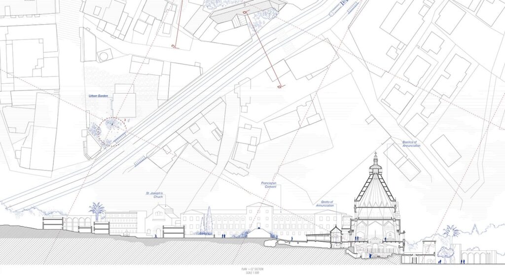
Despite its troubled history linked to ethnic-political events, Nazareth has preserved its characteristic of religious desti- nation for all the pilgrimages that interest the territories of the Holy Land. However, the tourist flows that pass through this small town of just 14km2 are massive and mismanaged. This phenomenon ends up negatively affecting the identity of a people outside the Israeli political-administrative fabric. This is an arab village looks at this problem and proposes a possible solution in architectural and urban planning terms.
Urban planning, architecture, Masterplanning, competition, urban design
The conflicts of 1956, 1967 and 1973 opened the door to the tragedy of the so-called “occupied territories”: the Golan Heights, the Gaza Strip and the West Bank, which became permanent guerrilla camps. In 1949, following the unrest due to the proclamation of the new state, almost 1 million Palestinians were expelled from their homeland.
The Six-Day War in 1967, which saw Israeli troops excel over attacks by Egypt and other Arab countries, had once again changed the borders of the State of Israel. The borders of the occupied territories still do not seem to us to be rigid or fixed at all; on the contrary, they are elastic and constantly changing. The linear frontier, which is a cartographic abstraction of the concept of spatiality linked to the nation-state, is here translated into: dividing walls, checkpoints, barriers, emergency closures, areas foreclosed to civilians, special security zones, sterile areas. These border areas are dynamic, flowing and flowing all the time, they advance crawling and surrounding Palestinian villages and roads by surprise. Sometimes they even found walls and break into Palestinian homes. The anarchist geography of the frontier has a form in continuous transformation and evolution redesigned and reordered on the occasion of each political change. One of the most important strategies for obscuring Israeli policies on occupied lands is based on terminology. The extraordinary wealth of settlement terminology, in Hebrew, was actively used after 1967 to cloud the boundaries between Israel and the occupied areas, and functioned as a kind of sophisticated semantic counterfeiting. The Israeli-Palestinian conflict is therefore so interesting from the point of view of space because the whole process of colonization itself responds to two complementary strategic planning actions: destruction and construction.
Urban planning, architecture, Masterplanning, competition, urban design
ISRAEL AREAS AND PALESTINIAN TERRITORIES
The territorial conflict in the Holy Land has reformulated all the principles of governability of places. When the State of Israel was declared independent on May 14, 1948, there was a contradictory policy of decolonization mainly by Great Britain and France. Palestine had never enjoyed independence: first part of the Ottoman Empire and, immediately after the First World War, the southern area came under the Franco-English government. The Versailles treaties assigned Palestine to the British protectorate that will never entrust independence to Jews and Arabs.
To limit Jewish supremacy and not break the alliance with Islamic countries, Jewish immigration was limited to 75,000 at the beginning of the Second World War. After the end of the war, the emotional wave of the Holocaust and the need of the Jewish people to belong to the places in its history meant that immigration to Palestine was no longer hindered. In May 1948, the Great Britain announced at the UN the withdrawal from the British State of Palestine and in November of that year the United Nations Assembly proposed the division of the region into two areas, providing for the assignment of the Negev area to the Jewish people. The Arab states voted against it.
When British troops left the Middle East, a year later, the State of Israel was proclaimed.
The creation of a state founded on religious and racial grounds triggered a reaction from the Arab-Palestinian troops, thus beginning a new, interminable military season.
Urban planning, architecture, Masterplanning, competition, urban design
THE PROJECT 
 
The urban planning intervention of the city of Nazareth revolves around three main themes. Starting from the development of a light metropolisation system on Paulus Ha-Shishi street, we continue with the design of the two heads (north terminal and south terminal). In order to be able to understand in the intervention the entire urban system of Nazareth, a quadrangular urban grid is set up over the whole city in whose intersections are positioned elements of microarchitecture such as wind towers, urban rooms and for Islamic prayer, thus providing services not only for tourist flows but also for those who live in the places.
It is a project that is carried out not only by places and architecture but also by people, by the drama caused by the search for a place to which you can belong. Man as a reason before architecture in his indispensable search for physical relations with the earth and in his desire for place.
Urban planning, architecture, Masterplanning, competition, urban design

Thesis Title: This Is An Arab Village | A Project For Nazareth

Name: Emanuela Schirone

University: IUAV University of Venice

Related articles

UDL Thesis Publication 2024

Curating the Best Thesis Projects Globally !

Leave a Reply

UDL Photoshop

Masterclass

Decipher the secrets of

Urban Mapping and 3D Visualisation

Session Dates

4th-5th May, 2024

Urban Design

Post-Thesis Opportunities and Resources

Join the largest social media community!

0 + K

Join Our WhatsApp Group

Recent Posts

Sign up for our Newsletter

“Let’s explore the new avenues of Urban environment together “

A Comprehensive Guide (Free E-book)

A Comprehensive Guide To Thesis Report Writing For Architecture And Urban Studies