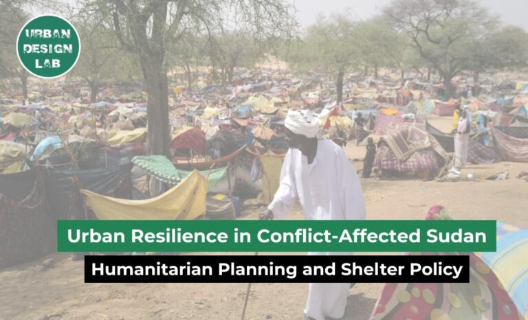
The crisis of climate change and related disasters poses growing challenges to the future of cities. Compared to rural areas, urban settlements especially low-income communities are more vulnerable to both natural and human-made disasters. According to NOAA and Emergency Events Database (EM-DAT), 27 major disasters in the U.S. alone caused $182.7 billion in damages, while 393 global disasters affected 167.2 million people and resulted in $241.95 billion in economic losses in the year of 2024. Rising sea levels and global warming continue to threaten major cities like Jakarta and New York. Unpredictable events such as earthquakes and armed conflicts further complicate the creation of sustainable urban settlements. Unlike in the past, however, today’s technological advances, particularly in artificial intelligence, offer powerful new tools for rebuilding and redesigning cities after such crises.
In the process of Post disaster revitalization for the settlements, the categories of the process may include
Post Disaster Assessment
Urban Area Site Analysis and Assessment
Design, Planning and Visualization
Project Management and Planning
Project Implementation and Construction
Project Risk Analysis and Safety
Early Warning and Simulation for Future Disasters
In each category, the followings are some insightful and useful AI tools that can support this process.
Post Disaster Assessment
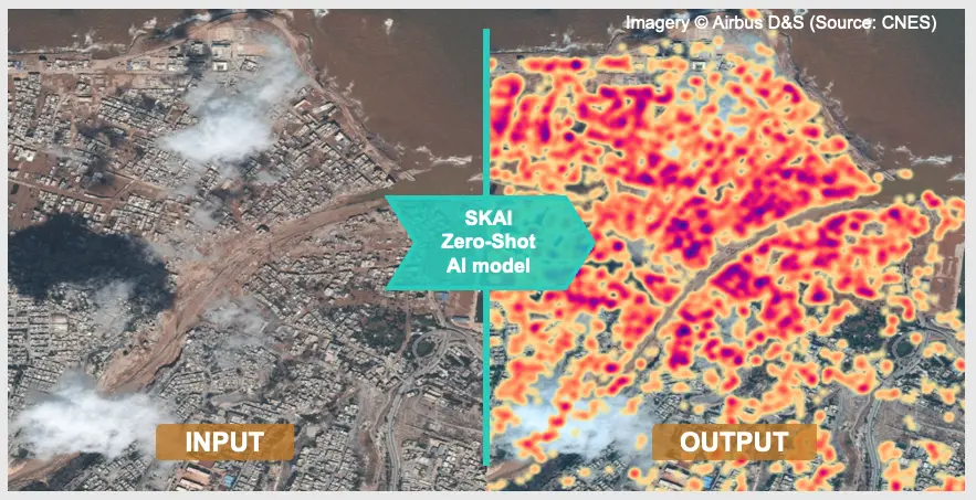
In the aftermath of destructive disasters like storms, earthquake, armed conflicts and wars, it is quickly critical to make rapid and accurate identifications on damaged infrastructure in affected areas. The faster the analysis is done, the more disaster responses will be improved and save lives and economics. In the present, beyond traditional surveying, Artificial Intelligence (AI) tools are revolutionizing post-disaster assessment by enabling faster, more scalable, and data-driven evaluations. The tools like Google Earth Engines and Microsoft’s Planetary Computer can be used to integrate AI with Satellite Imagery to analyze changes between pre and post disasters. In addition, other tools such as Open Buildings, SKAI Zero-Shot, and the SKAI Fine-Tuned models can be applied to identify areas with the most building damage. They can also label the extent of damage by comparing pre-event and post-event images, and classify the damage levels of the remaining buildings using machine learning. These applications were implemented in the global emergencies like 2024 Bangladesh Floods, 2023 Syrian Earthquake, Tropical Cyclone RAI in the Philippines 2021 by the UNOSAT team.
Libya Dam Collapse (2023): SKAI Zero-Shot AI used post-disaster satellite images to detect building damage
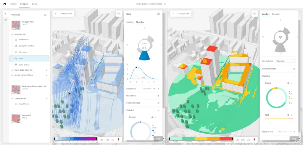
Starting from the scratch for revitalization process on Settlements, the post and Site Analysis of the resettlement area or new settlements is a first initial step for Design and Planning. At present, combining with traditional observation, the AI has significantly enhanced the deep and precise analysis of the task. Autodesk Forma (Previously known as Spacemaker) are helping the early-stage design process to simulate site existing conditions such as sunlight, wind flow, noise levels, and topography. The other tools, Google Earth Engine, also can be used as the AI empowerment tool for tracking land use, vegetation cover, water bodies changes and topographic transformation over time. In addition, Urban Footprint, which combines with AI can be applied to select the safe, equitable locations for Post Disaster settlements by understanding geographic, demographic and Climate data. If you are intended to use Rhino and Grasshopper for further planning and modelling process, the plugins, for instance, Ladybug, Honeybee and Dragonfly can stimulate and provide additional data for solar radiation, daylight autonomy, thermal comfort, and wind behavior which may be essential for Climate and Disaster responsive designs.
Wind and Sun Analysis using Autodesk Forma
Source: Website Link
Design, Planning and Visualization
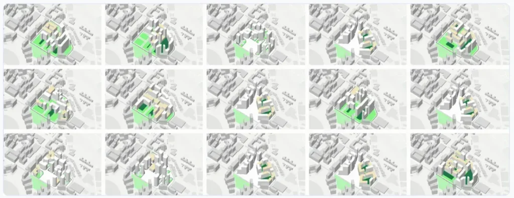
As the technologies become advanced, the intelligent systems can support architects and urban designers in shaping sustainable cities effortlessly. These tools can simulate, optimize, and visualize urban environments before construction, helping reduce errors and showing how spaces will look and function once built. AI can quickly assess building layouts based on energy efficiency, cost, livability, and inclusivity when designing settlements and urban forms. Delve by Sidewalk Labs, in collaboration with Google Earth, is an AI-powered generative design tool that optimize urban layouts for efficiency, sustainability, and livability. The tool analyses land use, transport, and infrastructure to reduce resource use and support sustainable design. Features include rapid scenario generation, real-time data analysis, 3D visualization, and collaborative tools. In a case study of a 12-acre mixed-use site in Wembley Park, London, Delve analyzed 40,000 design options and produced 24 top-performing variants within 8 weeks, improving housing yield, daylight access, and overall livability compared to the original plan. Alongside traditional rendering tools, AI-driven platforms such as NVIDIA Omniverse, Unreal Engine (Twinmotion), and Arkiooffer real-time rendering and immersive design. They enable planners to simulate realistic, walkable urban spaces by integrating natural light, vegetation, and pedestrian flow through AI-enhanced environmental data.
Design Options Generating with Delve by Sidewalk in Wembley Park
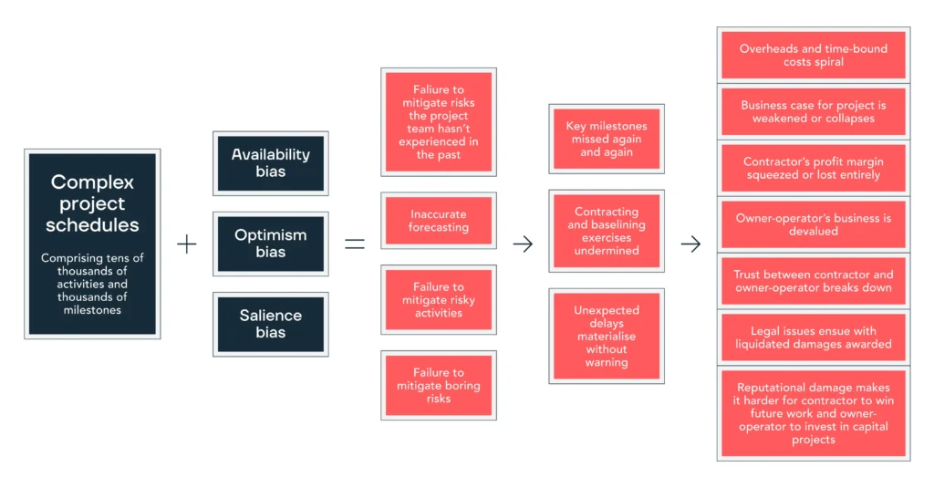
Following the planning and design phases, maintaining a balance between timing and quality is crucial—especially in phased projects like post-disaster rehabilitation. AI-powered project management and planning tools play a key role in accelerating timelines, minimizing human errors, and enhancing coordination among various teams in the construction sector. Tools like Alice Technologies and nPlanleverage AI to analyze schedules, anticipate risks, and optimize construction sequences, allowing for faster and more efficient recovery. By analyzing extensive historical project data, these platforms can predict delays, highlight critical paths, and suggest improved resource allocation. Additionally, platforms such as PlanRadar and Autodesk Construction Cloud combine AI with BIM to track progress, manage tasks, and maintain clear communication in high-pressure environments. A notable application of these technologies was seen during the “Build Back Better Plan” by Japan International Cooperation Agency (JICA) launched after the devastating Turkey–Syria earthquakes in February 2023. AI-driven planning and risk assessment tools helped coordinate logistics and resource distribution across various sectors. By automating repetitive tasks and providing real-time insights, these tools significantly enhanced collaboration among architects, engineers, contractors, and local authorities throughout the recovery process.
nPlan Construction Management solutions Infographics
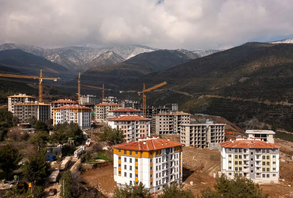
During the project implementation and construction phrase, AI can support and efficient time, budget and manpower and boost accuracy and real-time decision-making. The solutions by Buildotsand Versatile utilize AI and computer vision with data from drones, wearable cameras, or sensors to monitor site progress. By comparing on-site conditions to digital Building Information Modeling (BIM), the tools can detect delays, flag quality issues, and keep the project aligned with the schedule. For instance, the AI tool, Buildots generates true-to-life progress reports supported by visuals, providing managers and stakeholders with accurate, objective data and indepth analysis, leading to improved efficiency while constructing new Royal Bournemouth Hospital in the UK during pandemic. Related to Post-disaster Resettlements, After the 2023 Turkey earthquake, UNDP implemented the Clean Construction System, originally developed by Seoul Metropolitan Government. It includes Allimi, a digital platform that publicly shares real-time updates on reconstruction projects, covering material use, labor, and progress. The Clean Construction System is a digital framework for managing public construction projects. Through its online portal, residents can track reconstruction progress on the infrastructures with real-time transparency. It improves not only communication between authorities and the public but also rebuilding public trust during post-crisis recovery.
Aerial view of new constructed residential buildings after the earthquake in Hatay, Turkey, @ REUTERS/Umit Bektas
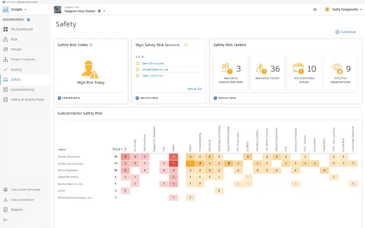
In post-disaster reconstruction, risk management and ensuring safety are critical due to tight schedules, unstable environments and high vulnerability on the workers and project team. Besides human decisions, AI tools provide accurate assistance by forecasting potential project risks, improving on-site safety, and supporting informed decision-making. The Platforms like nPlanand Smartvid.io can flag high-risk activities, suggest preventive actions, and even identify unsafe behaviors through video analytics. Moreover, Construction IQ by Autodesk is another AI-driven solution that evaluates project data to prioritize safety and quality issues. Construction IQ uses its machine learning technology, giving laser sharp focus in terms of the health and safety issues onsite, enabling the management teams to focus and track leading safety indicators. Through the Quality Risk Factor card in both the Autodesk Construction Cloud platform and BIM 360, the tools can raise a flag that can be a potential high risk earlier in the process, thus, the construction team can eliminate the weak and threat points before they significantly impact the quality of the project.
Construction Risk Analysis with Construction IQ by Autodesk
In the rehabilitation of post-disaster settlements AI technologies are increasingly crucial for strengthening early warning systems and simulating potential future disasters, thereby minimizing long-term risks and enhancing urban community resilience. These intelligent systems analyze a wide range of data—from climate patterns and seismic records to satellite imagery and historical disaster data—to predict and anticipate upcoming hazards. AI is also embedded in real-time weather and climate forecasting platforms, helping urban planners prepare for events such as floods, extreme heat, or severe storms. A notable example is Google’s Flood Hub, which uses AI to track and predict water levels, including monitoring flood conditions in Myanmar during Typhoon Yagi in 2024. Similarly, GraphCast, developed by the UK Met Office and DeepMind, delivers highly accurate cyclone path forecasts, detects atmospheric rivers associated with flooding, and forecasts temperature extremes up to 10 days ahead, allowing cities to plan ahead more effectively. Beyond forecasting, AI-powered disaster simulation tools help visualize and assess the impact of natural and human-made hazards in cities. Tools like MIT Senseable City Lab and MIT Urban Risk Lab allow planners to test resilience strategies virtually, as seen in the Resilient SF2080 project, which explores future-proof urban planning in disaster-prone areas.
Resilient SF 2080 Illustration, Smart Grid by Kyle Barker, Mingx Zou
As climate change and global instability increase the frequency and intensity of disasters, rebuilding urban settlements requires not only speed but also smarter, more resilient approaches. AI tools can be a linking bridge in that process from scratch to complete in revitalization process after post-disaster. However, on the other hand, architects and urban designers must be aware that the new settlements should be human centered, inclusive, community sensed and biodiversity preserved. Based on Human kind sense combing with AI technology can enhance settlements to more livable and resilience.
Nay Myo Htet is currently studying architecture at President University, Indonesia, and is a recipient of the EMPM Scholarship. His interests focus in climate-responsive design, inclusive urban development, and the preservation of cultural heritage. Previously, he worked with Doh Eain as an Assistant Architect, contributing to heritage restoration and the revitalization of public spaces in Yangon. As the Myanmar Youth Representative for SEACHA, he actively promotes cultural sustainability and regional climate action. Through both design and academic research, Nay Myo is committed to advancing climate-resilient architecture and urban strategies across Southeast Asia.
“Let’s explore the new avenues of Urban environment together “
We use cookies on our website to give you the most relevant experience by remembering your preferences and repeat visits. By clicking “Accept”, you consent to the use of all the cookies. Read More
This website uses cookies to improve your experience while you navigate through the website. Out of these, the cookies that are categorized as necessary are stored on your browser as they are essential for the working of basic functionalities of the website. We also use third-party cookies that help us analyze and understand how you use this website. These cookies will be stored in your browser only with your consent. You also have the option to opt-out of these cookies. But opting out of some of these cookies may affect your browsing experience.
Necessary cookies are absolutely essential for the website to function properly. These cookies ensure basic functionalities and security features of the website, anonymously.
Cookie
Duration
Description
cookielawinfo-checkbox-analytics
11 months
This cookie is set by GDPR Cookie Consent plugin. The cookie is used to store the user consent for the cookies in the category "Analytics".
cookielawinfo-checkbox-functional
11 months
The cookie is set by GDPR cookie consent to record the user consent for the cookies in the category "Functional".
cookielawinfo-checkbox-necessary
11 months
This cookie is set by GDPR Cookie Consent plugin. The cookies is used to store the user consent for the cookies in the category "Necessary".
cookielawinfo-checkbox-others
11 months
This cookie is set by GDPR Cookie Consent plugin. The cookie is used to store the user consent for the cookies in the category "Other.
cookielawinfo-checkbox-performance
11 months
This cookie is set by GDPR Cookie Consent plugin. The cookie is used to store the user consent for the cookies in the category "Performance".
viewed_cookie_policy
11 months
The cookie is set by the GDPR Cookie Consent plugin and is used to store whether or not user has consented to the use of cookies. It does not store any personal data.
Functional cookies help to perform certain functionalities like sharing the content of the website on social media platforms, collect feedbacks, and other third-party features.
Performance cookies are used to understand and analyze the key performance indexes of the website which helps in delivering a better user experience for the visitors.
Analytical cookies are used to understand how visitors interact with the website. These cookies help provide information on metrics the number of visitors, bounce rate, traffic source, etc.
Advertisement cookies are used to provide visitors with relevant ads and marketing campaigns. These cookies track visitors across websites and collect information to provide customized ads.