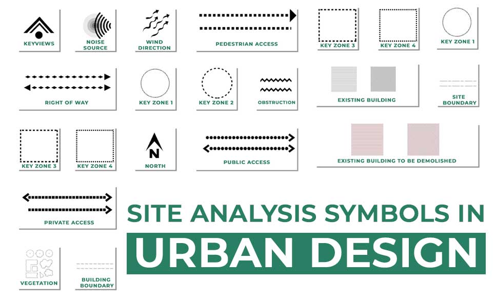
Site analysis symbols in urban design are graphical representations used to represent various features and elements of a site. These symbols are used to represent the physical, social, economic, and environmental characteristics of a site and are an important tool for urban designers and planners in the process of understanding the complexities of a site and determining the most appropriate design solution.
There are a variety of site analysis symbols that can be used, each representing different elements of the site. For example, symbols can be used to represent the physical features of a site, such as the topography, vegetation, and existing buildings. Symbols can also be used to represent the social and economic characteristics of a site, such as the population density, income level, and cultural diversity of the area. In addition, symbols can be used to represent the environmental characteristics of a site, such as the presence of natural resources, pollution levels, and potential for flooding or other natural disasters.
Site analysis symbols are an important tool for urban designers and planners because they help to clearly and concisely communicate the various characteristics of a site. By using standardized symbols, designers and planners can quickly and easily convey information about a site to others, such as colleagues, clients, and the wider community. This allows for more efficient communication and decision-making, as well as a greater level of transparency and understanding of the design process.
In addition to being a useful tool for communication, site analysis symbols can also be used to help inform the design process itself. By clearly identifying the various characteristics of a site, designers and planners can better understand the constraints and opportunities presented by the site and develop design solutions that are sensitive to these factors.
There are four fundamental elements that are included in plans to help us understand, orientate and interpret them. In urban design projects we will seldom find illustrations fully explained without the use of a:
Key
Title block
North point
Scale
1. Key
It is vital to provide keys or legends, particularly on drawings when the information is not self-explanatory.
2. Title Block
The title block establishes the authority of the plan ordrawing. It should provide information about the author and owner, as well as the drawing itself. Drawings and plans may have a legal status and responsibility must be recorded. A title block should have the following information:
drawing title
drawing reference number
the author
the body taking responsibility
scale (both written and drawn)
date created
revision number
project codes.
3. North Point
The north point should always appear on drawings. It is useful for establishing aspect and shadow paths but mainly for ensuring that all concerned orientate all drawings the right way up.
There are effectively three types of north:
1. True north – the direction of a meridian of longitude which converges on the North Pole 2. Magnetic north- the direction indicated by a magnetic compass.
Magnetic north moves slowly with a variable rate and currently is west of grid north in Great Britain
3. Grid north – the direction of a grid line which is parallel to the central meridian on the Ordnance Survey® grid
4. Scale
Arrows
Arrows are used to depict direction – of movement, of view, of sun path for example – but may also be used to point to key features in or beyond the plan. It is better to avoid using both on the same plan, but if this is essential then the forms of the arrows should be distinct and explained in the key. Arrows should be designed so that their outline cannot be confused with elements ofthe base plan.
Line weights/types
Lines can also represent paths, movement or links. A hierarchy of lines can be established by:
Width
Tone
Type
The width of such lines can be used to represent the level of activity along a particular route. The tone of a line can be depicted by colour or shade and used to depict significance or emphasis. The type of a line – the relative interval of solid and space – can be used to depict levels of confidence or the provisional or conditional nature of what is depicted
Overall, site analysis symbols play a vital role in the process of urban design and planning. They provide a clear and concise way to communicate information about a site and can help inform the design process itself. By using these symbols, urban designers and planners can better understand the complexities of a site and develop design solutions that are appropriate and sensitive to the needs of the community.
1. Graphics For Urban Design by B. Meeda, N. Parkyn, the late D. S. Walton
2. Architecture Site Analysis Symbols – Archisoup
Urban Design Lab
About the Author
This is the admin account of Urban Design Lab. This account publishes articles written by team members, contributions from guest writers, and other occasional submissions. Please feel free to contact us if you have any questions or comments.
“Let’s explore the new avenues of Urban environment together “
We use cookies on our website to give you the most relevant experience by remembering your preferences and repeat visits. By clicking “Accept”, you consent to the use of all the cookies. Read More
This website uses cookies to improve your experience while you navigate through the website. Out of these, the cookies that are categorized as necessary are stored on your browser as they are essential for the working of basic functionalities of the website. We also use third-party cookies that help us analyze and understand how you use this website. These cookies will be stored in your browser only with your consent. You also have the option to opt-out of these cookies. But opting out of some of these cookies may affect your browsing experience.
Necessary cookies are absolutely essential for the website to function properly. These cookies ensure basic functionalities and security features of the website, anonymously.
Cookie
Duration
Description
cookielawinfo-checkbox-analytics
11 months
This cookie is set by GDPR Cookie Consent plugin. The cookie is used to store the user consent for the cookies in the category "Analytics".
cookielawinfo-checkbox-functional
11 months
The cookie is set by GDPR cookie consent to record the user consent for the cookies in the category "Functional".
cookielawinfo-checkbox-necessary
11 months
This cookie is set by GDPR Cookie Consent plugin. The cookies is used to store the user consent for the cookies in the category "Necessary".
cookielawinfo-checkbox-others
11 months
This cookie is set by GDPR Cookie Consent plugin. The cookie is used to store the user consent for the cookies in the category "Other.
cookielawinfo-checkbox-performance
11 months
This cookie is set by GDPR Cookie Consent plugin. The cookie is used to store the user consent for the cookies in the category "Performance".
viewed_cookie_policy
11 months
The cookie is set by the GDPR Cookie Consent plugin and is used to store whether or not user has consented to the use of cookies. It does not store any personal data.
Functional cookies help to perform certain functionalities like sharing the content of the website on social media platforms, collect feedbacks, and other third-party features.
Performance cookies are used to understand and analyze the key performance indexes of the website which helps in delivering a better user experience for the visitors.
Analytical cookies are used to understand how visitors interact with the website. These cookies help provide information on metrics the number of visitors, bounce rate, traffic source, etc.
Advertisement cookies are used to provide visitors with relevant ads and marketing campaigns. These cookies track visitors across websites and collect information to provide customized ads.