
Urban Planning Terminology
The world is witnessing an unprecedented urban transformation, with cities expanding and evolving at an astonishing rate. In this urban landscape, the science of urban planning becomes paramount. It involves a myriad of concepts, theories, and terminologies that shape the way our cities and communities develop. In this article, we’ll delve deeper into the world of urban planning, exploring additional essential terms, theories, and concepts that govern urban development.
Comprehensive Plan:
Within the field of urban planning, a complete Plan—which is sometimes used synonymously with the word Master Plan—is an essential tool that provides a thorough and complete framework for the ongoing and forward-looking development of a city. This comprehensive urban planning document is carefully crafted to integrate and balance a wide range of essential elements that are critical to the long-term development of the city.
Simply put, a comprehensive plan functions as a blueprint that successfully expands its scope beyond the limitations of temporal immediacy to include a future vision for the city.
Development Plans:
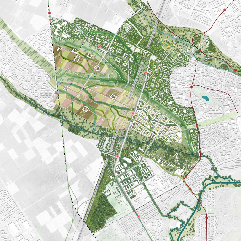
Development plans, also referred to as urban or municipal plans, are fundamental tools used in land management and urban planning. These painstakingly created documents offer a comprehensive guide for the strategic use and development of land within a predetermined geographic jurisdiction. Their range includes a plethora of important elements that when taken as a whole mold a community’s or region’s social, economic, and physical environment.
Development plans are fundamentally authoritative manuals that carefully detail land-use classifications, zoning laws, and a complete set of development standards. These regulations define the acceptable uses for different property lots as well as the physical layout of public facilities, transit hubs, and infrastructure.
In addition, these plans frequently include long-term goals for sustainable growth and development, taking into account things like housing shortages, economic development, environmental sustainability, and the protection of natural resources. Development plans seek to achieve a careful balance between promoting economic vitality and preserving the standard of living for locals through in-depth study, stakeholder involvement, and assessment of local and regional priorities.
Structure Plans:
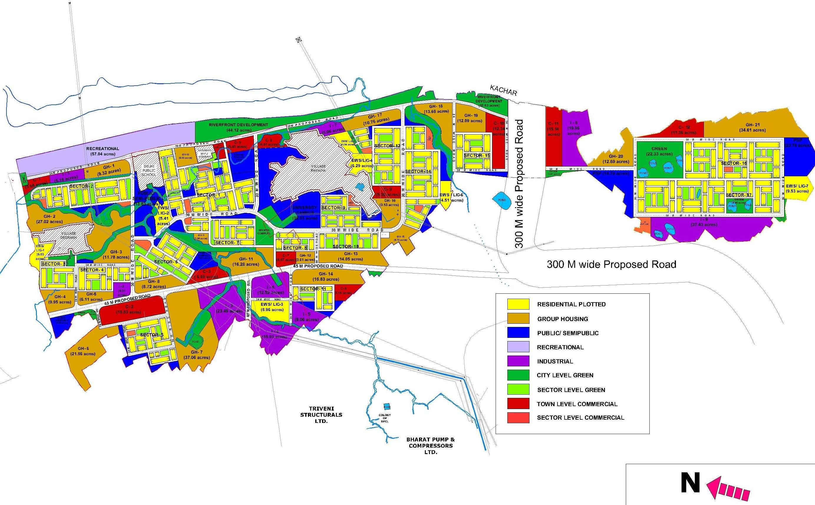
Structure plans are instrumental documents in the realm of urban planning, offering a structured framework for the physical advancement of urban areas. These plans primarily concentrate on delineating the spatial arrangement and strategic development of critical elements, including infrastructure, transportation networks, and the organization of diverse land-use zones encompassing residential, commercial, and industrial areas.
Structure plans serve as the foundational cornerstone upon which urban development endeavors are built. They provide a comprehensive roadmap that outlines the spatial configuration of urban regions, aiming to achieve an efficient, sustainable, and aesthetically pleasing urban environment.
Zonal Plans:
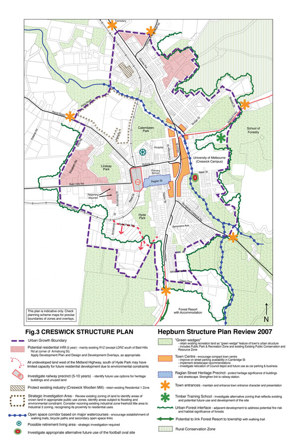
Within the larger framework of development plans, zonal plans play a crucial role by providing a targeted and detailed approach to urban or regional planning. The primary purpose of these plans is to divide a city or area into discrete zones, each governed by precise and well-defined land-use laws. The principal aim of zonal plans is to carefully distribute land and direct the spatial arrangement of diverse activities, so as to guarantee that land uses are suitably positioned and peacefully coexist.
The accurate distribution of land for a wide range of uses, such as institutional, commercial, industrial, residential, and recreational ones, is a strength of zonal planning. Planned land use is clearly categorized by the demarcation of these zones in zonal plans, which facilitates effective planning and development.
The regulatory framework that defines the allowable uses, density, building heights, and other development criteria within each zone is established by zonal plans. By encouraging compatibility and reducing conflicts across land uses, these laws are specifically designed to meet the criteria and distinctive qualities of the specified land-use category.

Area Development Plans:
Area Development Plans (ADPs) are a tactical method of urban planning that carefully examine specific areas or districts that are part of a larger metropolitan municipality. These carefully designed plans are carefully tailored to capture the unique needs and challenges that arise in these defined areas, with the ultimate goal of improving the general welfare and quality of life of the residents residing there.
ADPs are a prime example of a comprehensive urban planning paradigm that is distinguished by its keen attention to limited geographic areas within the urban fabric. These designs are carefully designed to accommodate the unique socio-economic, environmental, cultural, and infrastructure quirks that are specific to the places that they are intended for. By doing this, they enable a nuanced and contextually appropriate method of tackling the various opportunities and difficulties that arise within these boundaries.
City Development Plans:
City Development Plans (CDPs) are a crucial tool in urban governance and strategic urban planning. They provide a comprehensive and forward-thinking framework for the overall advancement and growth of a municipality. The aforementioned documents serve as comprehensive representations of several aspects that are crucial to the development of urban areas. They include a wide range of characteristics including housing, transportation, economic growth, and environmental sustainability.
At its essence, Customer Data Platforms (CDPs) serve as strategic tools, guiding the course of urban development towards a predetermined vision. Urban planners coordinate a complex interplay of policies, initiatives, and investments, ensuring the synchronization of different aspects of urban growth to achieve a harmonious and prosperous urban environment. The provision of housing, for example, is carefully examined to ensure fair and equal access to shelter for all individuals, while transportation systems are streamlined to enhance efficient mobility, so promoting economic development and social unity.
Development Schemes:
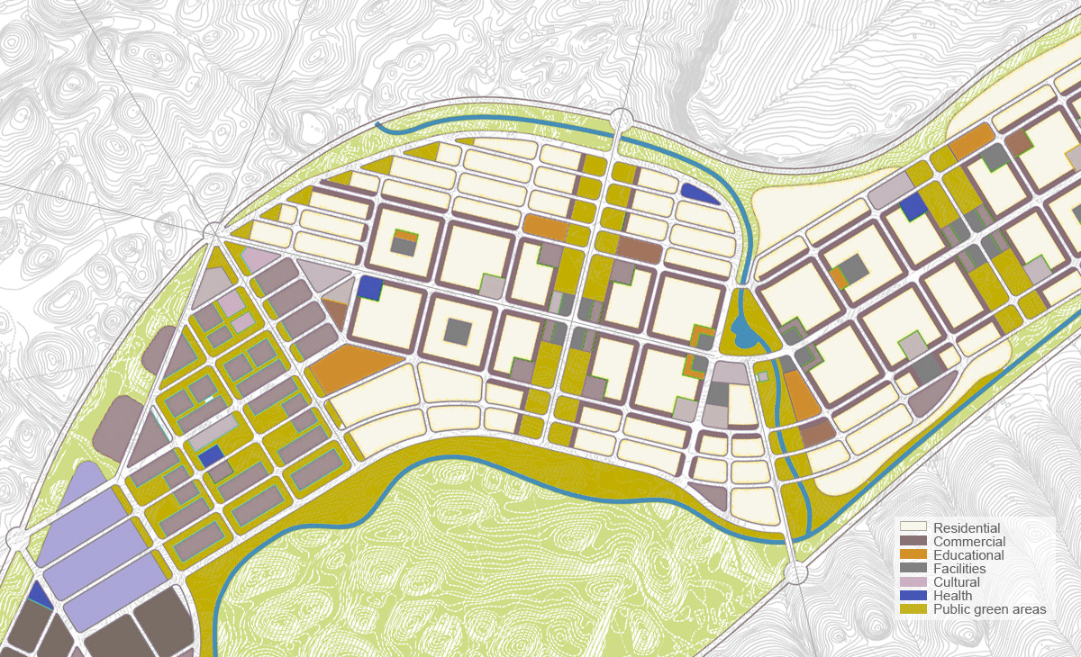
Development schemes are detailed plans that are carefully thought out and created for the use and alteration of particular land parcels or projects. These plans include a variety of important components, including site plans, architectural drawings, and feasibility studies, which when taken as a whole offer a comprehensive blueprint for the intended development project. The assembly of these fundamental elements not only provides a path for the project’s physical implementation but also acts as evidence of the project’s feasibility, structural soundness, and compliance with legal and ecological requirements. Development schemes, to put it briefly, are a comprehensive and well-supported method of organizing and carrying out real estate and building projects, guaranteeing that they meet predetermined criteria for sustainability, usability, and beauty.
Zoning variance:
A zoning variance is a legal exception or waiver granted by a local government or zoning board to allow a property owner or developer to deviate from the existing zoning regulations or land-use restrictions applicable to their property. Zoning regulations dictate how land can be used, including factors such as building height, setback requirements, land use types (residential, commercial, industrial, etc.), and other development standards.
When a property owner believes that adhering to these zoning regulations would result in undue hardship or prevent reasonable use of their property, they can apply for a zoning variance. To obtain a variance, the applicant typically needs to demonstrate that:
- There are unique circumstances or hardships specific to their property that make it difficult to comply with the existing zoning regulations.
- Granting the variance would not adversely affect the surrounding properties or the general public interest.
- The request is in harmony with the overall intent and purpose of the zoning code and does not undermine the zoning plan’s integrity.
Planned Unit Development (PUD):
Municipal authorities use Planned Unit Development (PUD), a sophisticated land-use planning tool, to accommodate the changing and dynamic needs of suburban and metropolitan areas. Jurisdictions aim to respond to evolving societal needs, economic dynamics, and environmental concerns by creating PUD districts, which facilitate the creation of creative and flexible built environments.
PUDs, in essence, promote a comprehensive approach to land development by pushing developers and stakeholders to go beyond conventional zoning constraints. This strategy encourages the development of integrated communities in which commercial, residential, and recreational features coexist peacefully, fostering the growth of walkable neighborhoods that improve people’ quality of life in general. Local governments can successfully respond to the changing needs and desires of their constituents while preserving the ideals of sustainable and responsible development thanks to the PUD’s ability to provide customized land use and design solutions.
Transit-Oriented Development (TOD):
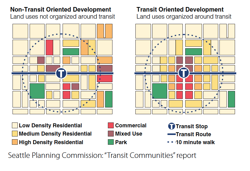
Transit-Oriented Development (TOD) is an urban planning and development approach that focuses on creating vibrant, sustainable, and well-connected communities around public transportation hubs, such as subway stations, bus stops, and commuter rail stations. The primary goal of TOD is to encourage people to use public transportation and reduce their dependency on private vehicles while simultaneously fostering economic, social, and environmental benefits.
Transit corridor:
A transit corridor refers to a specific route or corridor within a city or region that is designated for the operation of public transportation services, such as buses, trams, or commuter trains. These corridors are typically designed to efficiently connect key destinations, residential areas, and employment centers, promoting the accessibility and convenience of public transit for commuters and residents. Transit corridors often feature specialized infrastructure, like dedicated bus lanes or priority signaling, to facilitate the smooth flow of public transportation and reduce travel times, making them a fundamental element of transit-oriented planning and sustainable urban mobility.
Zoning Ordinance:
Legal documents known as zoning laws define and codify land use regulations that apply to specific geographic zones or territories under a jurisdiction. These ordinances function as all-inclusive documents that precisely delineate the development limitations and activities that are allowed inside each defined zone. Zoning rules are essential for controlling land use, maintaining neighborhood aesthetics, and protecting public interests because they define what kinds of land uses, buildings, and activities are permitted or forbidden in a certain zone.
These legislative rules cover a broad range of factors, including zoning for residential, commercial, industrial, and recreational purposes, among others. They generally cover issues including parking regulations and environmental protection measures, as well as criteria pertaining to building height, setbacks, lot size, and density. Thus, zoning rules play a crucial role in land management and urban planning by promoting harmonious and orderly development and guaranteeing that land use is consistent with the community’s larger goals and values.
Overlay Zone:
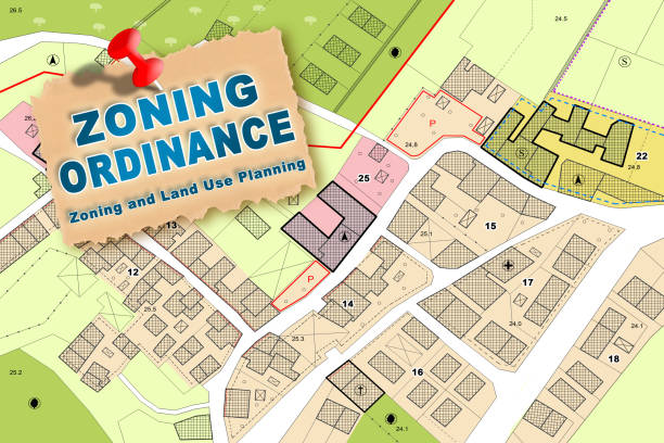
Overlay zones are additional zoning classifications that are placed on top of a jurisdiction’s current zoning map. The purpose of these specialist zoning districts is to handle particular, localized challenges or goals that may not be sufficiently addressed by the more general zoning categories. Overlay zones are used to add more regulations and limitations to a specific area, usually with the intention of solving particular issues or encouraging specialized land use practices.
Overlay zones, for instance, might be used to address problems like historic preservation, in which neighborhoods and historic buildings are protected by strict laws. As an alternative, they might be used to regulate floodplains, enforcing strict development and building regulations to reduce the risk of flooding and safeguard the ecosystem.
Density:
In the context of land use and urban planning, density refers to the number of individuals, structures, or activities in a given geographic region. It functions as a foundational measure of how concentrated or distributed various components are in a certain area. Higher concentrations of development, usually more densely packed buildings, and more people living, working, or doing activities per unit of land area are characteristics of high-density places. Low-density areas, on the other hand, show a more dispersed pattern, with fewer people or activities per unit of land and more widely spaced buildings and land uses.
Urban Sprawl:
The term “urban sprawl” refers to the unplanned, usually chaotic growth of urban centers into suburban and rural areas. This phenomena is generally typified by the rapid and haphazard construction of housing, commercial areas, and infrastructure, which frequently leads to inefficient land use and an increased reliance on automobiles for transportation.
Numerous low-density, single-use developments, vast road networks, and the encroachment of built-up regions into natural and agricultural lands are some of the ways that urban sprawl can appear. It frequently results in a variety of interrelated problems, including longer commutes, more traffic, and higher greenhouse gas emissions. It can also put a pressure on infrastructure and public services, requiring large investments in utilities, education, and emergency services to keep up with the expanding growth.
Greenfield Development:
The process of developing land that has not been previously developed for urban or industrial uses is known as “greenfield development.” Large areas of undeveloped or agricultural land are accessible for construction and infrastructure development on the outskirts or peripheral of cities, which is where this type of development usually takes place.
Urban planners, architects, and developers can create new communities, residential neighborhoods, commercial areas, or industrial complexes from the ground up via greenfield development. To support the expanding population and local economy, this may entail building additional road systems, utilities, housing, and other infrastructure projects.
Brownfield:
Brownfields are underutilized or abandoned commercial or industrial properties that may have contaminated the environment in the past as a result of industrial activity. These locations are usually found in metropolitan or semi-urban regions, and the community they are in may be at danger for health, safety, and the environment.
In order to address brownfields, urban planners must design plans for their redevelopment and environmental remediation. By repurposing and revitalizing existing locations, these tactics hope to reduce environmental risks and make them safe for future usage.
Infill Development:
The act of creating new structures or developments within of already-existing urban or suburban regions is known as “infill development.” Typically, these projects take place on underutilized or abandoned land that is surrounded by previously established properties. This strategy aims to lessen urban sprawl and the urge to expand on formerly undeveloped, undisturbed land (commonly referred to as “greenfield” development) while making better use of the infrastructure that is already in place, such as roads, utilities, and public services.
In regions that are already developed, infill development can take many different forms, such as the construction of new homes, businesses, or public areas. It seeks to encourage urban density, improve already-existing neighborhoods, and build more accessible and walkable communities. Because it minimizes the environmental impact of new infrastructure development and eliminates the need for long-distance commuting, infill development is frequently viewed as a sustainable and cost-effective strategy to urban growth.

Urban Heat Island (UHI):
A small area inside a city or metropolitan area that has noticeably hotter temperatures than the nearby rural areas is known as an urban heat island (UHI). Human activity and the features of the urban environment are the main causes of this phenomena. Important elements that play a role in the development of UHIs include:
UHIs can have a number of negative consequences, such as higher energy usage for cooling, worsened air quality problems, and greater health risks during heatwaves. In order to lessen these effects, they also emphasize the need of urban planning and design techniques including expanding green areas, utilizing reflective roofing materials, and encouraging energy-efficient building designs.

Conditional Use Permit (CUP):
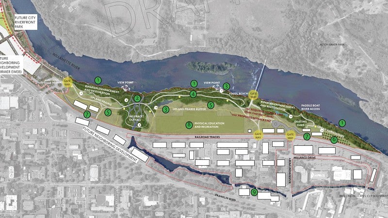
A Conditional Use Permit (CUP) is a type of regulatory license that allows certain land uses within a designated zoning district, provided that certain standards are met. With the use of this permitting system, zoning restrictions can be somewhat flexible, allowing for certain developments or activities that might not otherwise be allowed in the designated zone.
Local planning or zoning authorities usually go through a thorough examination procedure before issuing a Conditional Use Permit. This procedure involves a thorough evaluation of various aspects, including the planned use’s compatibility with the surrounding area, potential impacts on traffic, noise, or environmental concerns, and adherence to stipulated requirements or mitigation measures. To make sure that the interests and concerns of the community are taken into account, public hearings and input are sometimes included in the review process.
Community Development Block Grant (CDBG):
The Community Development Block Grant (CDBG) is a federal program in the United States administered by the U.S. Department of Housing and Urban Development (HUD). CDBG provides financial assistance to state and local governments to support a wide range of community development activities aimed at improving the quality of life for low and moderate-income residents in communities across the country.

Environmental Impact Assessment (EIA):
Environmental Impact Assessment (EIA) is a systematic process used to evaluate the potential environmental consequences or impacts of proposed projects, plans, policies, or programs before they are approved or implemented. The primary goal of an EIA is to identify and assess the environmental effects of a proposed action and provide information to decision-makers, stakeholders, and the public, enabling them to make informed decisions and mitigate any adverse environmental impacts.
Land banking:
Land banking is a real estate and urban planning strategy used to acquire, hold, and manage vacant or underutilized land for future development or community purposes. The primary goal of land banking is to control and strategically manage land in a way that aligns with long-term community development goals, rather than allowing it to be sold or developed by private entities without regard to broader community interests. This approach is often employed by local governments, nonprofit organizations, or quasi-public agencies.
Urban Design Lab
About the Author
This is the admin account of Urban Design Lab. This account publishes articles written by team members, contributions from guest writers, and other occasional submissions. Please feel free to contact us if you have any questions or comments.
Related articles


Architecture Professional Degree Delisting: Explained
Periodic Table for Urban Design and Planning Elements
History of Urban Planning in India
Best Landscape Architecture Firms in Canada
UDL GIS
Masterclass
GIS Made Easy – Learn to Map, Analyse, and Transform Urban Futures
Session Dates
23rd-27th February 2026

Urban Design Lab
Be the part of our Network
Stay updated on workshops, design tools, and calls for collaboration
Curating the best graduate thesis project globally!

Free E-Book
From thesis to Portfolio
A Guide to Convert Academic Work into a Professional Portfolio”
Recent Posts
- Article Posted:
- Article Posted:
- Article Posted:
- Article Posted:
- Article Posted:
- Article Posted:
- Article Posted:
- Article Posted:
- Article Posted:
- Article Posted:
- Article Posted:
Sign up for our Newsletter
“Let’s explore the new avenues of Urban environment together “












One Comment
Love it