By offering speed, precision, and adaptability in spatial analysis, Quantum GIS (QGIS) is a revolutionary tool for urban simulation. As cities face increasing complexity, planners use QGIS to model traffic, infrastructure, and environmental scenarios efficiently. Future developments, including AI and real-time simulations, promise even faster, more responsive simulations. Real-world applications in cities like Barcelona and Singapore highlight its social and economic impact. QGIS stands out as an essential, data-driven tool for designing resilient, smart cities equipped to handle rapid urban transformation.
Introduction to Quantum GIS and its evolution in urban planning
Quantum GIS refers to Quantum Geographical Information Systems, which is an open-source software enhanced by quantum computing principles that is used in urban planning. While cities continue to grow faster and more complex, urban planners need more precise tools that can process vast data sets with minimal errors. Quantum GIS relies on parallel processing to execute multiple tasks to enhance spatial analysis. It is also an adaptable platform for dynamic, data-driven needs in expanding cities and a starting point for forward-thinking models of planning.
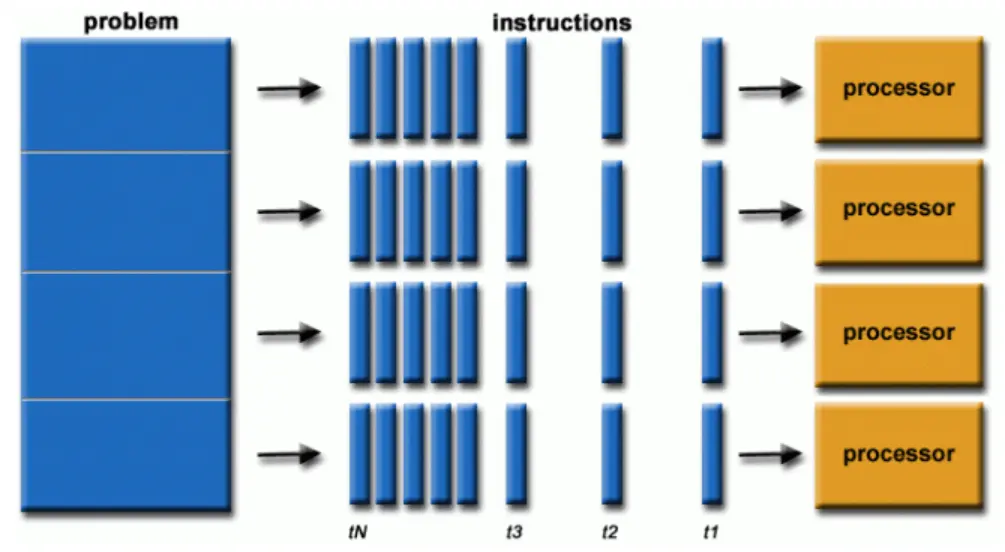
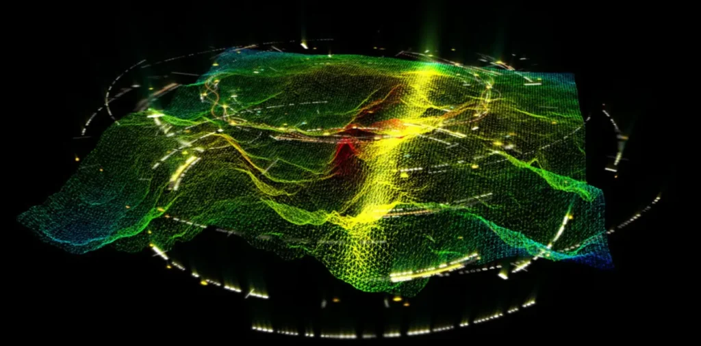
The parallel computation feature enables the simultaneous processing of multiple tasks, as several algorithms and plugins are optimized for parallelization. This allows them to leverage multiple CPU cores by decomposing larger tasks into smaller, more manageable units that can be processed rapidly. For instance, a 2024 study conducted by the MIT Urban Risk Lab reported a 75% reduction in the time required for earthquake vulnerability assessments. With such computational enhancements, urban planners can now perform multiple assessments within the timeframe previously needed for a single analysis.
This advancement significantly improves workflow efficiency and supports real-time decision-making in high-risk urban environments. Moreover, it facilitates the integration of complex datasets and simulation models, enhancing both predictive accuracy and operational responsiveness.
Parallel Computation
Source: Website Link
AI and Real-Time data integration
Quantum GIS (QGIS) also enhances analytical accuracy through the integration of artificial intelligence (AI) and real-time data sensors. Embedded machine learning algorithms within QGIS can analyze and predict urban heat island (UHI) effects with up to 95% accuracy by incorporating satellite imagery, thermal properties of building materials, and localized weather patterns. Notably, cities like Dubai have leveraged these tools to optimize green space configurations, successfully reducing peak urban temperatures by nearly 3°C.
Moreover, QGIS’s integration with the Internet of Things (IoT) allows for dynamic recalibration of spatial models. For instance, real-time traffic data can be utilized to update congestion models, while adaptive algorithms can optimize streetlight placement to maximize energy efficiency. These capabilities collectively support data-driven urban design and promote resilient, climate-responsive planning.
QGIS-Driven Design in Smart Cities - "Virtual Singapore" project
QGIS enables the integration of 3D city models to conduct real-time simulations of diverse urban phenomena—including flood risks, seismic activity, pedestrian movement patterns, and the optimization of street lighting systems. High-resolution drone imagery, LiDAR scans, and participatory data contributed by residents are utilized to refine infrastructure planning well before construction begins.
The outcome: significant cost savings, minimized disruptions during implementation, and compelling evidence that quantum-enhanced Geographic Information Systems (GIS) have transitioned from conceptual frameworks to operational tools, empowering the development of resilient, future-ready urban environments.
With its high potential, Quantum GIS still faces challenges, as any emerging tool. including the high cost of computational power required for parallel processing, which limits access to smaller cities. The skill gap that still exists for using the software and the need for specialised training. The risk of algorithmic bias due to biased data input may also be a threat that needs attention from planners to collect inclusive data and work on the development of open-source tools. Transparency in using AI-driven tools and simulations should be prioritised to ensure marginalised communities benefit from these advancements.
With QGIS enabling more automated decision-making, ethical considerations are present and also become a requirement in Quantum Urban Planning. Who controls the algorithms that shape our cities? Can simulations do justice to economic and social inequalities? One solution is Barcelona’s “Democratic Digital Twins” project, using participatory modelling to incorporate local resident feedback into QGIS scenarios. By embedding local feedback into data-driven processes as digital urbanism advances, maintaining this balance between technology and human-centred values will be essential.
Going forward, Quantum GIS has the potential to revolutionise climate adaptation planning. Researchers at ETH Zurich are experimenting with QGIS to model the impacts of sea-level rise at a hyper-local scale, predicting block-by-block flooding years or even decades in advance. Coupled with renewable energy optimisation software, such technologies can assist cities in achieving net-zero earlier. For urban laboratories, the emphasis must be on collaboration among governments, tech firms, and universities to democratise access and render Quantum GIS a driving force for sustainable, equitable urbanism.
During a time when cities must be adapting rapidly to environmental changes, Quantum GIS (QGIS) is one specialised tool for city planning. Its capacity to integrate speed and accuracy enables planners to model various detailed scenarios, incorporate real-time information, and confidently make informed decisions. As artificial intelligence, cloud computing, and smart technologies continue to transform the urban environment, and by utilising QGIS, urban planners and researchers can be at the forefront of creating cities that are not just more efficient and smart, but also more inclusive and sustainable for future generations.
References
Tyagi, Noopur & Singh, Jaiteg & Singh, Saravjeet & Sehra, Sukhjit. (2024). A 3D Model-Based Framework for Real-Time Emergency Evacuation Using GIS and IoT Devices. ISPRS International
Based_Framework_for_Real_Time_Emergency_Evacuation_Using_GIS_and_IoT_Devices
Gaglione, Federica. (2023). Urban planning and GeoAI in smart city policies. TeMA – Journal of
Malak is an architecture student at Helwan University, driven by a passion for urban resilience, human-centred design, and environmental justice. Her work often intersects with cultural context and social impact. At Urban Design Lab, she aims to explore global urban issues and contribute research that reflects both analytical depth and design sensitivity.
“Let’s explore the new avenues of Urban environment together “
We use cookies on our website to give you the most relevant experience by remembering your preferences and repeat visits. By clicking “Accept”, you consent to the use of all the cookies. Read More
This website uses cookies to improve your experience while you navigate through the website. Out of these, the cookies that are categorized as necessary are stored on your browser as they are essential for the working of basic functionalities of the website. We also use third-party cookies that help us analyze and understand how you use this website. These cookies will be stored in your browser only with your consent. You also have the option to opt-out of these cookies. But opting out of some of these cookies may affect your browsing experience.
Necessary cookies are absolutely essential for the website to function properly. These cookies ensure basic functionalities and security features of the website, anonymously.
Cookie
Duration
Description
cookielawinfo-checkbox-analytics
11 months
This cookie is set by GDPR Cookie Consent plugin. The cookie is used to store the user consent for the cookies in the category "Analytics".
cookielawinfo-checkbox-functional
11 months
The cookie is set by GDPR cookie consent to record the user consent for the cookies in the category "Functional".
cookielawinfo-checkbox-necessary
11 months
This cookie is set by GDPR Cookie Consent plugin. The cookies is used to store the user consent for the cookies in the category "Necessary".
cookielawinfo-checkbox-others
11 months
This cookie is set by GDPR Cookie Consent plugin. The cookie is used to store the user consent for the cookies in the category "Other.
cookielawinfo-checkbox-performance
11 months
This cookie is set by GDPR Cookie Consent plugin. The cookie is used to store the user consent for the cookies in the category "Performance".
viewed_cookie_policy
11 months
The cookie is set by the GDPR Cookie Consent plugin and is used to store whether or not user has consented to the use of cookies. It does not store any personal data.
Functional cookies help to perform certain functionalities like sharing the content of the website on social media platforms, collect feedbacks, and other third-party features.
Performance cookies are used to understand and analyze the key performance indexes of the website which helps in delivering a better user experience for the visitors.
Analytical cookies are used to understand how visitors interact with the website. These cookies help provide information on metrics the number of visitors, bounce rate, traffic source, etc.
Advertisement cookies are used to provide visitors with relevant ads and marketing campaigns. These cookies track visitors across websites and collect information to provide customized ads.