The Core Concept: What is AI-Driven Real-Time Simulation?
In this essence, AI-driven, real-time simulation means the integration of artificial intelligence with means of Geographic Information Systems (GIS) data, Internet of Things (IoT) sensors, traffic records, various utility data, with historical development and timeline records. These tools try to enable planners to: Simulate the after-effects of zoning changes instantly while predicting the long-term consequences of any specific decision. By continuously ingesting data from real-time sources; AI models can refine their possibilities and suggest how to stay aligned with current realities. Traditional zoning maps are very static and often reactive. With the help of AI, cities can implement technology like adaptive zoning, where land use designations shift in response to real-time aspects i.e. population density, economic activity, or environmental threads. Let’s for example consider during peak hours of the market commercial areas might temporarily expand to accommodate foot traffic, or in climate-sensitive zones, AI can identify overbuilt areas and suggest green buffer zones based on heat island effects and flood risk projections shortly. These models help us to make decisions and understand where we need reinforcement before development. How to prioritize investment in utilities while keeping the social or environmental trade-offs exist in various scenarios.
Urban planners can use AI to test multiple growth scenarios and instantly see their outcomes. The “digital twin” concept creates a virtual model of the city that planners and manipulate safely, and scenarios might include the following: Shortly the Housing schemes will consider 20% more residents while aiming for reducing energy emissions by 40% by 2035 and preparing for an increase in electric vehicle use. AI helps identify the most useful paths to achieve these targets by optimizing for cost, time, sustainability, and equity aspects. Enables forecasting of population growth, traffic patterns, energy use, etc. Propose multiple urban layouts with certain specified goals, such as maximum walkability or disturbance in the environment. Provides updates on land use and infrastructure maps with as minimal intervention as possible. Analyses the citizen feedback and integrates it into planning models. Captures and processes the real-time data from city sensors for on-the-fly decision-making. Planning cycles are shortened from months or years to days or hours, eliminating the guesswork with quantifiable data insights. Visual, real-time models make urban planning more accessible and inclusive. Cities can react to unforeseen changes like pandemics or climate events faster. Better investment decisions save taxpayers money in the long run.
Tourist areas can assess the flow of visitors at key attractions and resources can be applied to areas.
Source: Website Link
Challenges and Considerations
While however bright and beautiful promisingly it looks the challenges still stand strong like Data Privacy as real-time tracking and data collection must be balanced with citizens’ privacy rights and consent. Without careful training and oversight, models may reinforce existing social inequities which remain unsettled and result in future chaos. Not all cities have the technological infrastructure or skilled workforce to adopt these tools and dynamic zoning may require legal reforms and new frameworks of accountability. Government and other stakeholders should participate in this initiative of building a bright future based on Artificial Intelligence, IoT, and virtual simulations.
Managing emergencies and acts of God. Here, regional data reflects the dispossessed population and housing need.
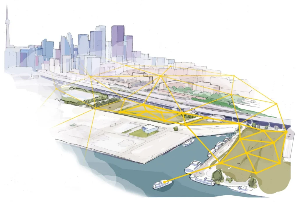
Real-Life Case Study: Sidewalk Toronto – Alphabet’s Smart City Project
Toronto, Canada: Project by Sidewalk Labs (a subsidiary of Alphabet/Google) in partnership with Waterfront Toronto. The Sidewalk Toronto was a proposed in 12-acre smart neighborhood on Toronto’s eastern waterfront, with the aim to use AI, sensors, and real-time simulations to dynamically adjust zoning regulations with a better-optimizing infrastructure performance and improve mobility, housing, and sustainability. Core Technologies used were like: AI/Tech Feature in mixed-used zoning to maximize walkability and economic diversity. The infrastructure Simulation core was a digital twin model, utility load, and environmental impacts on a real timeline. Modular buildings were proposed for floorplans with material optimization using Key Features & Innovations the project had was its dynamic Zoning, a live, data-rich model updated by sensors and AI forecasts to help traffic flows, building energy loads, and affordability impacts of zoning changes. The project was successful in demonstrating how AI and data could drive smarter, faster urban decision-making with Propose of sustainable infrastructure: heated sidewalks, smart waste management, and renewable energy integration. Massive public backlash over data privacy, surveillance, and corporate control is still a concern. The project was eventually canceled in 2020, partly due to the COVID-19 pandemic and political resistance.
Sidewalk Labs and Waterfront Toronto envision the “future city” to have a comprehensive digital infrastructure that will connect all neighbourhoods
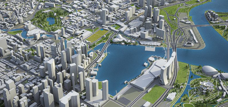
Virtual Singapore – National Digital Twin, Singapore
Singapore’s National Research Foundation + GovTech + Dassault Systèmes Ai Integration is a real-time digital twin of the entire nation, simulates zoning changes, infrastructure planning, and emergency responses and AI & machine learning usage to forecast Traffic congestion, Energy consumption, and Population movement patterns. This project will simulate how new developments affect surrounding zones. An AI-driven tool for urban redevelopment, optimizing housing layouts and land use. Virtual Singapore, is a 3D digital twin used to test zoning, green buildings, and transport plans. The Green Mark Scheme was introduced to achieve 40% of buildings being certified as green. Further Smart Water Grid came with AI to detect leaks and forecast water demand. And at last Autonomous EV Trials: Reducing carbon transport footprint in Marina Bay and Punggol districts
Virtual Singapore: National Digital Twin, Singapore
The integration of AI into urban planning marks a significant leap forward in how cities are designed, managed, and experienced. Governments, urban planners, and technologists must collaborate to ensure that AI-powered planning remains ethical, inclusive, and responsive. Real-time zoning and infrastructure simulations are no longer futuristic concepts—they are the new foundation for building smart, resilient cities. As this technology matures, cities that embrace it early stand to gain significant advantages in sustainability, liability, and economic competitiveness.
References
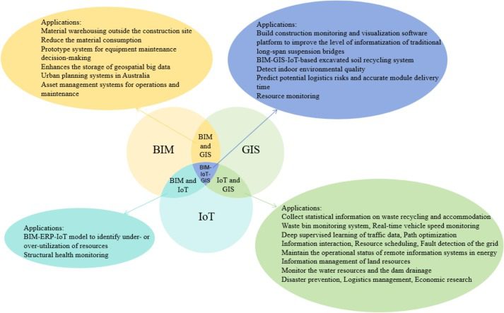
Liu, X., Antwi-Afari, M. F., Li, J., Zhang, Y., & Manu, P. (2025). BIM, IoT, and GIS integration in construction resource monitoring. Automation in Construction, 174, 106149. https://doi.org/10.1016/j.autcon.2025.106149
What Is a Geographic Information System (GIS)? (n.d.). Spiceworks. https://www.spiceworks.com/tech/tech-general/articles/geographic-information-system/
AI in Architecture: The Key to Enhancing Design Efficiency and Gaining a Competitive Edge. (n.d.). Www.e-Zigurat.com. https://www.e-zigurat.com/en/blog/ai-in-architecture-guide/
7.AI in Architecture: Benefits, Use Cases, and Examples. (2025, May 30). OpenAsset. https://openasset.com/resources/ai-and-architecture/
Steenson, R. (2019, April 25). The history of Geographic Information Systems (GIS) | BCS. Www.bcs.org. https://www.bcs.org/articles-opinion-and-research/the-history-of-geographic-information-systems-gis/
Mansourihanis, O., Maghsoodi Tilaki, M. J., Armitage, R., & Zaroujtaghi, A. (2025). Evolution and prospects of Geographic Information Systems (GIS) applications in urban crime analysis: A review of literature. Remote Sensing Applications: Society and Environment, 38, 101583. https://doi.org/10.1016/j.rsase.2025.101583
Piras, G., Muzi, F., & Virginia Adele Tiburcio. (2024). Enhancing Space Management through Digital Twin: A Case Study of the Lazio Region Headquarters. Applied Sciences, 14(17), 7463–7463. https://doi.org/10.3390/app14177463
Pawar Ishika Ramesh
About the Author
Architecture Student | Sustainability Enthusiast | Research interest in C&D Waste Management
Ishika Pawar is a passionate storyteller with a background in architecture and urban design, now expanding into journalism to explore the intersections of design, culture, technology, and society. She has a keen eye for detail, the ability to translate complex ideas into compelling narratives & committed to uncovering insightful stories.
“Let’s explore the new avenues of Urban environment together “
We use cookies on our website to give you the most relevant experience by remembering your preferences and repeat visits. By clicking “Accept”, you consent to the use of all the cookies. Read More
This website uses cookies to improve your experience while you navigate through the website. Out of these, the cookies that are categorized as necessary are stored on your browser as they are essential for the working of basic functionalities of the website. We also use third-party cookies that help us analyze and understand how you use this website. These cookies will be stored in your browser only with your consent. You also have the option to opt-out of these cookies. But opting out of some of these cookies may affect your browsing experience.
Necessary cookies are absolutely essential for the website to function properly. These cookies ensure basic functionalities and security features of the website, anonymously.
Cookie
Duration
Description
cookielawinfo-checkbox-others
11 months
This cookie is set by GDPR Cookie Consent plugin. The cookie is used to store the user consent for the cookies in the category "Other.
cookielawinfo-checkbox-functional
11 months
The cookie is set by GDPR cookie consent to record the user consent for the cookies in the category "Functional".
cookielawinfo-checkbox-performance
11 months
This cookie is set by GDPR Cookie Consent plugin. The cookie is used to store the user consent for the cookies in the category "Performance".
cookielawinfo-checkbox-analytics
11 months
This cookie is set by GDPR Cookie Consent plugin. The cookie is used to store the user consent for the cookies in the category "Analytics".
viewed_cookie_policy
11 months
The cookie is set by the GDPR Cookie Consent plugin and is used to store whether or not user has consented to the use of cookies. It does not store any personal data.
cookielawinfo-checkbox-necessary
11 months
This cookie is set by GDPR Cookie Consent plugin. The cookies is used to store the user consent for the cookies in the category "Necessary".
Functional cookies help to perform certain functionalities like sharing the content of the website on social media platforms, collect feedbacks, and other third-party features.
Performance cookies are used to understand and analyze the key performance indexes of the website which helps in delivering a better user experience for the visitors.
Analytical cookies are used to understand how visitors interact with the website. These cookies help provide information on metrics the number of visitors, bounce rate, traffic source, etc.
Advertisement cookies are used to provide visitors with relevant ads and marketing campaigns. These cookies track visitors across websites and collect information to provide customized ads.