Top 10 Transit – Oriented Development Case Studies
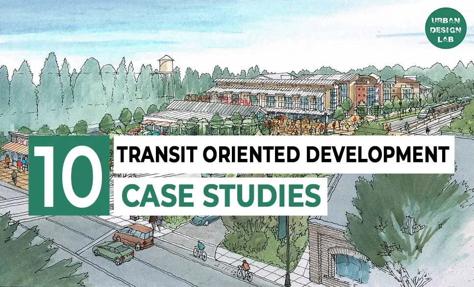
The impact that Transit-Oriented Development has provided to cities arise from the connection of public transport and urban designs for developing livable and sustainable communities. Some of the cities that are leading from front include Delhi, Ahmedabad, Pune, Hong Kong, Tokyo, São Paulo, Singapore, Curitiba, Vancouver, and Portland.
- Delhi: Decrease in congestion and pollution, increase in property value.
- Ahmedabad: Increase accessibility and public transport promotion.
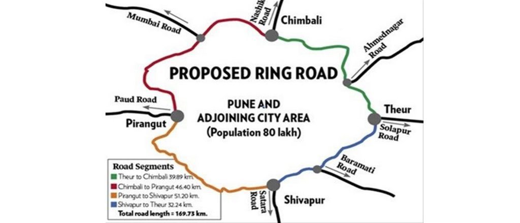
- Pune: Improved connectivity; improved economic growth.
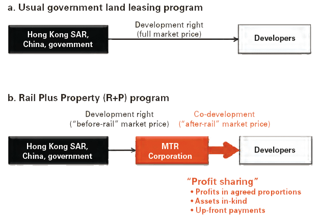
- Hong Kong MTR: Economically viable due to the “Rail plus Property” mechanism.
- Tokyo: High-density development, resulted in better air quality and decreased car-dependency.
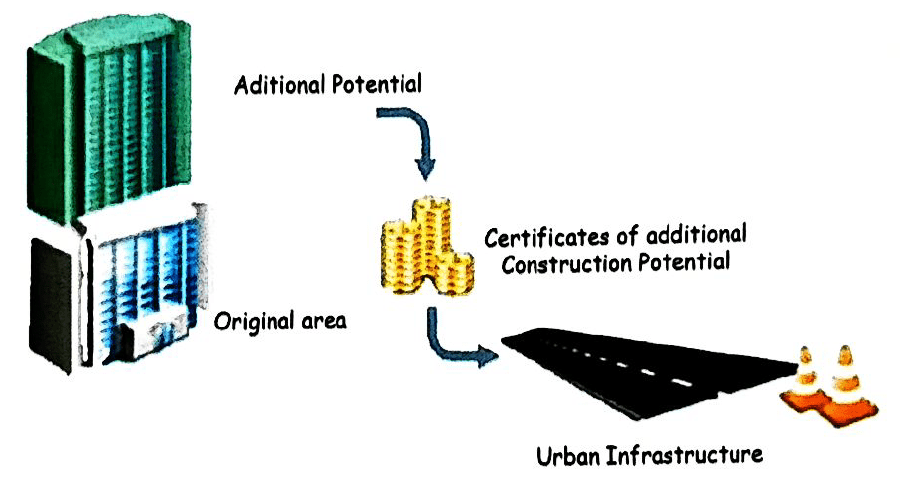
- São Paulo: CEPACs, the infrastructure funding mechanism, benefited affordable housing.
- Singapore MRT: Management of growth and reducing car use through high development densities.
- Curitiba BRT: The global symbol of sustainable urban development implemented along exclusive bus ways.
- Vancouver SkyTrain: Enhancing quality of life and cutting CO2 emissions.
- Portland: Focused on walkable neighbourhoods and preservation of green space.
The most frequent themes are mixed-use development, affordability, high-density growth, and innovative financing. Some governments help in the development and implementation of inclusive TOD policies, often fit with strategic planning. Examples abound on how these policies translate into creating efficient, connected, and vibrant urban environments.
Case Study 1: Delhi Metro Rail Corporation (DMRC), India
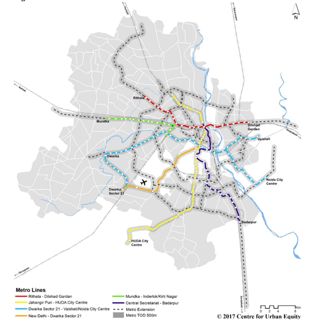
Launched in 1995, the Delhi Metro Rail Corporation (DMRC) represents a transformative effort to alleviate traffic congestion and enhance urban mobility within India’s capital. As an iconic case of Transit-Oriented Development (TOD), the Delhi Metro initiative was designed to meet the challenges of a rapidly growing population and an overburdened transportation network. The project required strategic planning to accommodate dense urban areas, limited land resources, and integration with other forms of public transit. By establishing an interconnected network of metro lines that seamlessly links with buses, auto-rickshaws, and cycle rickshaws, the DMRC created a cohesive system that provides a flexible and user-friendly travel experience. Additionally, mixed-use developments were built near metro stations to promote walkability and make essential amenities easily accessible, further strengthening the TOD approach.
The outcomes of the DMRC initiative reveal its substantial impact on the city’s urban fabric and socio-economic landscape. Traffic congestion and pollution levels around metro corridors have markedly decreased, highlighting the effectiveness of TOD in managing urban transport challenges. Property values have risen significantly in areas near metro stations, emphasizing the project’s role in elevating the economic profile of its surroundings. The DMRC’s success underlines key planning insights: transit-oriented models are critical in addressing mobility demands, while mixed-use developments around transport hubs play an essential role in fostering sustainable growth in rapidly urbanizing areas. This model not only optimizes transit systems but also aligns with broader urban planning objectives, serving as a vital reference for emerging cities aiming to balance mobility and development.
Case Study 2: Ahmedabad Bus Rapid Transit System (BRTS), India
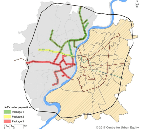
Launched in 2009, the Ahmedabad Bus Rapid Transit System (BRTS) was developed as a strategic initiative to introduce an efficient, bus-based public transport network aimed at enhancing urban mobility. Addressing critical challenges such as optimizing the city’s existing road infrastructure, ensuring high ridership and public acceptance, and seamlessly linking BRT lanes with city planning, the project was designed to transform public transit into a more accessible and appealing choice. The system features dedicated bus lanes, modern stations, and frequent services, thereby minimizing waiting times and promoting a reliable and user-friendly transit experience. The BRTS also incorporated design elements that support non-motorized transport, reflecting an inclusive approach to urban mobility that encourages diverse, sustainable transport options.
The BRTS initiative has positively impacted Ahmedabad’s urban landscape, notably improving accessibility, reducing travel times by 20%, and promoting public transit over private vehicle use. The success of the BRTS highlights several key planning insights: frequent and reliable transit services, coupled with designated lanes, are critical components of an effective BRT system. Additionally, integrating non-motorized transport infrastructure into the system enhances overall mobility and encourages sustainable urban development. As an example of a thoughtfully implemented public transit project, the Ahmedabad BRTS demonstrates the benefits of a well-planned and executed bus-based transport model for cities facing rapid urbanization and transportation challenges.
Source: Website Link
Case Study 3: Pune Metro, India
The Pune Metro project, inaugurated in 2016, is an ambitious undertaking aimed at alleviating the escalating traffic congestion and pollution in Pune, one of India’s rapidly urbanizing cities. With a steadily growing population and expanding urban boundaries, Pune faced an urgent need for a reliable and sustainable public transit solution to support its socio-economic development. The metro system, spanning a total of 29.2 kilometers with 23.33 kilometers elevated and 5.87 kilometers underground, has been meticulously designed to minimize land acquisition and disrupt as little of the existing urban fabric as possible. A pivotal feature of this design is its seamless connectivity with other modes of transportation, notably through well-integrated stations that facilitate smooth transfers to PMPML buses, enhancing last-mile connectivity and creating a cohesive public transit network. This integrated approach embodies the principles of Transit-Oriented Development (TOD), aiming to interlink mobility solutions and promote compact, accessible urban growth.
The impacts of the Pune Metro on the city are multifaceted, yielding significant benefits across various domains. For example, transit time between key locations like Pimpri and Swargate has been substantially reduced, enhancing commuter convenience and relieving road congestion. Additionally, the metro has stimulated economic development, with property values near metro stations witnessing an increase of 10-15% and nearby retail and commercial spaces thriving as a result. Projections for 2025 estimate a daily ridership of over 560,000 passengers, signaling substantial shifts in urban travel patterns and quality of life for Pune’s residents. This project highlights crucial planning insights, such as the strategic combination of elevated and subterranean tracks for optimal land use and minimal disruption, and the importance of multimodal integration to achieve TOD objectives. The Pune Metro thus not only addresses the city’s immediate transportation challenges but also reflects a thoughtful, future-oriented urban planning model that prioritizes sustainable growth and enhanced quality of urban life.
Case Study 4: Hong Kong's MTR, China
In response to Hong Kong’s dense population and constrained land resources, the city has uniquely integrated its Mass Transit Railway (MTR) with urban development since the 1970s. Recognizing the need for sustainable financial and spatial strategies, the MTR Corporation partnered with the government to implement a “Rail plus Property” (R+P) model. This approach leverages land development rights in the areas above and surrounding transit stations, generating significant revenue through real estate. By aligning transit stations with high-density, mixed-use developments that include residential, commercial, and retail spaces, the MTR system provides both accessible transit and valuable urban infrastructure. The R+P program has enabled the MTR to finance 38% of its infrastructure through real estate development, reducing dependency on government subsidies and facilitating the creation of self-sustaining transit infrastructure within the city’s compact urban landscape.
The MTR’s success reflects key planning insights critical to transit-oriented development (TOD) models. Hong Kong’s approach to land value capture has allowed the MTR system not only to fund its operations but also to drive higher usage of public transit among residents, alleviating congestion and minimizing the environmental footprint. High-rise, mixed-use developments around stations encourage efficient land use, compact urban living, and vibrant local economies, showcasing the potential for transit infrastructure to support broader urban goals. However, the success of this model depends heavily on government collaboration and strategic planning, as evidenced by the fact that 66% of the total investment for MTR was recovered through the R+P program. This model offers a compelling blueprint for cities facing similar spatial and financial constraints, demonstrating the value of integrating transit and urban development within a cohesive, sustainable framework.
Case Study 5: Tokyo, Japan
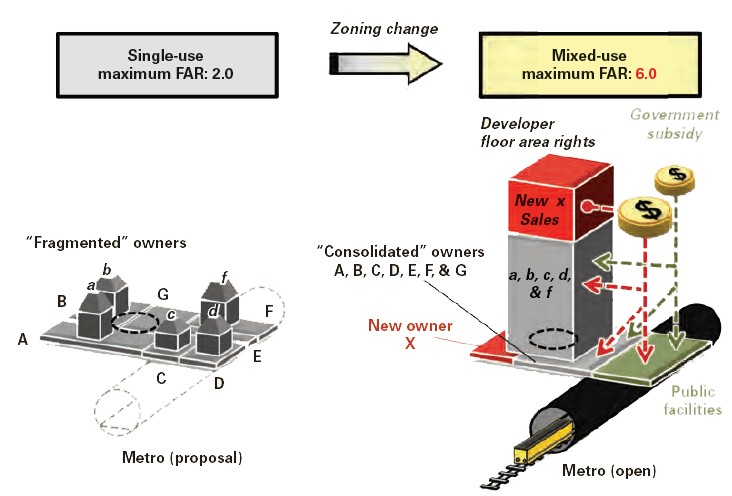
Tokyo, one of the world’s most populous cities, has long been recognized for its advanced public transit infrastructure and exemplary urban planning strategies. With the pressures of rapid urbanization, Tokyo embraced Transit-Oriented Development (TOD) to create an extensive and efficient network of trains and metro lines that seamlessly integrates with high-density residential, commercial, and mixed-use developments. The privatization of railways was a crucial factor in this transformation, enabling a highly coordinated approach to land use that prioritized accessibility, quality of life, and sustainable urban growth. Through this integrated model, Tokyo has managed to accommodate its expanding population while minimizing land wastage, promoting efficient transit, and maintaining high standards of urban livability.
The results of Tokyo’s TOD approach are significant, with the city achieving a balance between dense development and livability. Real estate development around transit hubs has been essential in financing the transit infrastructure, with a land redevelopment strategy recovering 36% of the mass transit costs. The establishment of a dedicated urban railway reserve fund and the strategic involvement of the government in land rearrangement and zoning have further supported the city’s TOD goals. As a result, Tokyo has successfully reduced car dependency, improved air quality, and alleviated traffic congestion. Key planning insights from Tokyo’s model include the importance of seamless connectivity and robust government involvement in land use regulation. Tokyo’s approach serves as a pioneering example of how urban transit and land use can be harmonized to achieve a sustainable, accessible, and high-quality urban environment in a rapidly urbanizing metropolis.
Case study 6 - São Paulo, Brazil
São Paulo, the largest city in Brazil, faces a range of interconnected urban challenges due to its high population density, sprawling metropolitan area, and persistent traffic congestion. Transit-Oriented Development (TOD) has emerged as a critical strategy to counter these issues by promoting more efficient urban growth patterns and enhancing residents’ quality of life. A notable mechanism within São Paulo’s TOD strategy is the electronic auctioning of limited building rights through Certificates of Additional Construction Potential (CEPACs), which allow developers to purchase additional building space rights (up to 2 sqm), thus generating substantial funding for public infrastructure. This auction system, along with the gradual release of Floor Area Ratio (FAR) increments, exemplifies how São Paulo has creatively leveraged private investment to support urban infrastructure and reduce the city’s reliance on car-centric transportation networks.
To address the complexities of population growth and affordable housing provision near transit hubs, São Paulo’s TOD framework integrates a range of policies, including the promotion of affordable housing initiatives, the strategic use of air rights sales, and the active involvement of the government in urban development through the Urban Development Fund. Funds generated through CEPACs, which have raised over $2.1 billion between 2004 and 2012, directly support infrastructure projects and highlight the potential of TOD to not only alleviate urban congestion but also generate significant public revenue. These policies, underscored by robust planning and financial incentives, aim to foster a more transit-dependent urban fabric, ensuring sustainable growth and improved accessibility. The success of São Paulo’s TOD approach demonstrates the importance of comprehensive planning and policy support to harness the full revenue-generating potential of building rights sales, as evidenced by their contribution to both public infrastructure and municipal finance.
Singapore's MRT
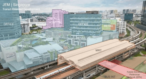
Singapore, a densely populated island city-state, has faced significant challenges in managing urban growth due to its limited land availability and rapidly expanding population. To address these issues, the government introduced the Mass Rapid Transit (MRT) system in 1987, aiming to create an advanced public transportation network to support Transit-Oriented Development (TOD). This approach focused on reducing car dependency, optimizing land use, and fostering a highly connected urban environment. MRT stations were strategically integrated into high-density development areas, blending residential, commercial, and retail spaces to facilitate efficient urban living. For instance, Jurong East exemplifies this TOD approach, where MRT connectivity supports a vibrant mix of housing and businesses. The “Rail plus Property” model, inspired by Hong Kong’s approach, has been instrumental in financing the MRT system by leveraging property development around transit hubs. To further discourage car ownership, the government implemented policies like the Certificate of Entitlement (COE) system and high vehicle taxes, shaping a more transit-oriented culture in the city.
The results of Singapore’s TOD strategy have been transformative, with high ridership levels on the MRT system and efficient land utilization around transit stations leading to well-connected, pedestrian-friendly neighborhoods. Reduced car dependency highlights the effectiveness of government policies in fostering a culture of public transit. Key insights from Singapore’s experience underscore that TOD integration around transit hubs promotes sustainable urban development, while the “Rail plus Property” model supports the financial self-sufficiency of public transit systems. The robust government policies aimed at limiting car ownership further bolster public transit use, making Singapore’s approach a compelling example of TOD’s potential to achieve sustainable urban growth in land-constrained contexts.
Case Study 8: Curitiba, Brazil
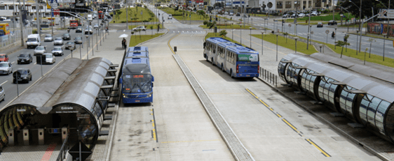
Curitiba, a city in Brazil, faced substantial challenges in addressing rapid population growth amid limited financial resources. To navigate these constraints, the city pioneered the Bus Rapid Transit (BRT) system, an innovative and cost-effective transit solution that has since become a model for sustainable urban transport worldwide. This system provided a robust foundation for Transit-Oriented Development (TOD) while optimizing available resources. By creating dedicated bus lanes that facilitate seamless city-wide accessibility, Curitiba’s BRT system enhances mobility for residents across income levels. High-density development areas, like the Green Line corridor, have been strategically encouraged along the BRT routes to stimulate localized growth and economic activity. Additionally, the city prioritized affordable housing along these transit corridors, ensuring that lower-income residents have equitable access to the benefits of urban connectivity.
The outcomes of Curitiba’s BRT-centered TOD approach have been transformative, fostering high ridership, reducing car dependency, and providing substantial environmental benefits through decreased pollution and expanded green spaces. The well-planned BRT corridors, flanked by high-density neighborhoods, have successfully managed urban sprawl and promoted efficient land use. Notably, Curitiba’s use of a BRT system, as opposed to costlier rail-based options, underscores the potential for budget-conscious cities to achieve sustainable and socially inclusive urban development. Key planning insights from Curitiba’s experience reveal that BRT systems offer a financially viable alternative for cities facing budget constraints, while TOD frameworks and affordable housing policies contribute to social equity and enhanced urban mobility.
Case Study 9: Vancouver, Canada
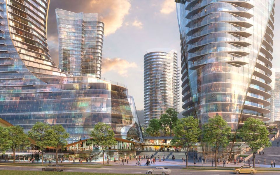
Vancouver, a city renowned for its sustainable urban growth, has leveraged Transit-Oriented Development (TOD) to reduce car dependency and foster compact, high-density neighborhoods around its SkyTrain stations. This automated rapid transit system, comprising the Expo, Millennium, and Canada Lines, has been central to Vancouver’s strategy for creating accessible, mixed-use areas that integrate residential, commercial, and public spaces. By focusing development around transit hubs, Vancouver addresses the dual challenges of managing a growing urban population and providing affordable housing options. Notable projects such as the Marine Gateway and Oakridge Centre exemplify this approach, incorporating diverse land uses to create vibrant communities. Policies like the Affordable Housing Choices Interim Rezoning Policy have further supported the integration of affordable housing near transit, ensuring that TOD benefits extend to various income groups.
The impacts of Vancouver’s TOD efforts are significant, with nearly half of all trips made by walking, cycling, or public transit, marking a shift towards non-car commuting. This approach has enhanced urban livability and improved environmental sustainability by reducing greenhouse gas emissions and improving air quality. Key insights from Vancouver’s TOD implementation highlight the necessity of inclusive policies and robust support mechanisms for successful urban planning. The city’s emphasis on mixed-use development around transit stations and strategic land-use planning has fostered more connected and resilient communities. Vancouver’s model underscores the importance of zoning and land use strategies in shaping sustainable urban settings that prioritize public transit, walkability, and environmental stewardship.
Case Study 10: Portland, Oregon, USA
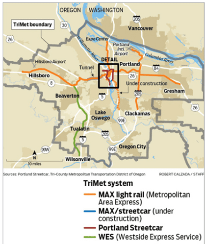
The Transit-Oriented Development (TOD) initiative that began in the 1980s marked a pivotal step toward sustainable urban growth, emphasizing the reduction of car dependency and addressing issues of urban sprawl. This approach centered on the development of neighborhoods along newly established Light Rail Transit (LRT) lines, creating compact, walkable areas with a balanced mix of residential and commercial functions. Key to this vision was the MAX Light Rail, a critical element in establishing TOD along LRT corridors. To support these transit-oriented developments, zoning laws were revised to allow higher densities and mixed uses near transit stations, while urban growth boundaries were introduced to control sprawl and preserve surrounding nature trails. These measures aimed to foster high-density urban centers that support public transit, while also conserving the region’s natural landscapes.
The outcomes of this TOD approach have been transformative, with the MAX Light Rail experiencing a marked increase in ridership and the rejuvenation of communities along its routes. These neighborhoods have flourished, with thriving mixed-use spaces that enhance both accessibility and livability. Notably, TOD’s success in these areas highlights the importance of community engagement in planning processes and underscores the need for careful densification paired with green-space preservation. Lessons from this TOD model reveal that well-coordinated land-use and zoning policies are essential to achieving a sustainable balance between urban growth and environmental conservation, while also ensuring that residents have access to affordable housing and vibrant, walkable neighborhoods.
Conclusion
Analysis of 10 case studies indicates that successful TOD is founded upon some basic principles.
Integration of transit stations with mixed-use development, this not only encourages public transit use but also supports financial sustainability through real estate development, as in Hong Kong, Singapore, and Tokyo.
Government policy and strategic planning involvement, including zoning laws, funding mechanisms, or incentives for high-density development. Cities like Copenhagen and Vancouver have offered fine examples of how robust policies, together with inclusive planning, can set a course toward improved livability and environmental sustainability in cities.
City like São Paulo demonstrate the need for policies that would offer affordable housing with TOD for social equity.
Discouraging car dependency results in less pollution and traffic jams, which is environmental. BRT in Curitiba metro have shown how to mitigate severe pollution levels and promote water urban surroundings via efficient public transport systems in very effective way.
The keys to success for TODs are, therefore, essentially strategic land use, holistic planning, and government support. Mixing land uses with high densities in the areas around transit and combining public transit with urban planning can help in creating more sustainable, lively, and accessible urban environments.
References
- Suzuki, H. et al. (2015) FINANCING TRANSIT-ORIENTED DEVELOPMENT WITH LAND VALUES.
- NIUA and Shakti Foundation (2020) ‘VALUE CAPTURE FINANCE IN TRANSIT ORIENTED DEVELOPMENT: A Guide to Implementation A Guide to Implementation’. Available at: www.niua.org.
- Smith (2011) ‘Principle 4 Build Transit-Oriented Developments (TODs)’.
- Joshi, R. et al. (2017) Transit-Oriented Development: Lessons from International Experiences.
- ADDIN Mendeley Bibliography CSL_BIBLIOGRAPHY Asian Development Bank (2022) Realizing India’s Potential for Transit-Oriented Development and Land Value Capture- A Qualitative and Quantitative Approach. Available at: https://www.adb.org/sites/default/files/publication/812521/india-transit-oriented-development-land-value-capture.pdf.
Meena Saini
About the Author
Meena is a dedicated architect and urban planner celebrated for her innovative and sustainable design approach. A young professional, she combines technical expertise with imagination and inquisitiveness. Known for her transparency and adaptability, Meena offers creative, unconventional solutions to urban challenges. Her modesty belies a fast learner committed to excellence. Focused on enhancing urban environments through thoughtful, sustainable design, Meena is dedicated to making a significant impact in her field.
Related articles
UDL GIS
Masterclass
GIS Made Easy – Learn to Map, Analyse, and Transform Urban Futures
Session Dates
23rd-27th February 2026

Urban Design Lab
Be the part of our Network
Stay updated on workshops, design tools, and calls for collaboration
Curating the best graduate thesis project globally!

Free E-Book
From thesis to Portfolio
A Guide to Convert Academic Work into a Professional Portfolio”
Recent Posts
- Article Posted:
- Article Posted:
- Article Posted:
- Article Posted:
- Article Posted:
- Article Posted:
- Article Posted:
- Article Posted:
- Article Posted:
- Article Posted:
Sign up for our Newsletter
“Let’s explore the new avenues of Urban environment together “
















3 Comments