Concentric Zone Model

The concentric zone “model” designed by Ernest Burgess was developed and considered as an urban planning “model” regardless of its nature and context. It would appear that the commonality in meaning is “abstraction of reality,” with the aim of either better understanding a real system or being able to predict its behaviour in relation to the cities.

Concentric Zone Model

The process of urban planning is based on people’s previous demands and experiences. The planning approach taken by each city must be tailored to its users and must allow for the daily smooth operation of all allied functions. Architects, planners, and philosophers from various cultural backgrounds proposed several ideas with the explicit goal of building an effective planning model capable of resolving zoning, environmental, and even social difficulties. In the late nineteenth century, various schools of thought arose to convey their visions of what a perfect city would look like. One such concept that arose in the early 1990s was the concentric zone model.


In 1925, Ernest W. Burgess proposed the concept of concentric zones. (1925, Burgess). Burgess proposed that urban land use is organised around the central business district (CBD) in concentric rings (see fig. 2), with each ring including a different land use. This concept was developed based on research conducted in Chicago from the 1980s to the early twentieth century. Because it is the most accessible site, the CBD (Zone I) is the city’s centre and comprises shops, offices, hotels and restaurants, theatres, banks, and other amenities. The CDB is surrounded by a transition zone, which is being invaded by business and light manufacturing (Zone II). Workers in Zone III work in industries that have moved out of the degradation zone (Zone II) but still wish to reside close to their workplace. Beyond this are high-end apartment complexes’ residential zones (Zone IV) or exclusive’restricted’ single-family home districts. The commuter zone (Zone V) extends beyond the city limits and comprises suburban communities or satellite cities within 30–60 minutes of the CBD. ‘Invasion’ and’succession’ have been used to describe the process of change in residential spatial patterns. As the city grew and developed in the transition zone, the CBD would exert pressure on the area immediately surrounding it. Outward expansion of the CBD would encroach on nearby residential areas, forcing residents to relocate. The trend was likely to continue, with each neighbourhood moving further away from the central business district. Burgess claimed that immigrants and low-income families predominantly populated inner-city dwellings. Lower-income individuals went to outlying districts as the city grew and the CBD stretched outward, while more affluent residents moved further away from the CBD. This theory was remarkable for discovering a positive relationship between household income and location of residence, with more affluent households reported to live further away from the CBD.


Understanding the Concentric Zone Model 2
Concentric zone model representing different rings

The Burgess Model (also known as the Concentric Zone Model) is an attempt to comprehend spatial organization and settlement patterns. For several decades, urban areas have been the subject of study. The way people live, where urban structures emerge, and how people interact and behave has always been an intriguing issue. With the expansion of urban population and urban development over time, we humans have inhabited practically every area of the planet. Human adaptation necessarily occurs later when environmental changes takes priority. Humans can adapt to the extremities of living environments and develop living conditions in deserts, flood plains, tropical locations, cold areas, and anywhere else they desire to. This has been made feasible by rising technological advances and the ability to manage and regulate the environment. 


Concentric zone model and population density

The density of population in specific places is heavily influenced by concentric zones. Population densities vary according to zone. The population decreases as you move out from the central zones. Commuter zones are much smaller than Working Class Residential zones because there are much fewer people with lower level degrees and education than people with higher level degrees and education. This occurs in all zones that are smaller in form since it is believed that the closer to the city centre the more people will live there, and of course, fewer people have a lot of wealth to spend on their housing.


The Reason for Concentric Zone Theory

The Burgess model takes into account the positive correlation between economic status and distance from downtown. This is sometimes also referred to as concentric zone model or simply concentric model or concentric theory. This considers, better the socio-economic status more the distance from the central area. The central area has high density, and the availability of land is scarce. In attempt to explain the structure and growth of cities, he proposed the concentric zone theory. This theory proposes that cities grow and develop externally in concentric zones. In other words, the model’s primary tenet is that when a city grows, it expands radially from its core to several concentric circles or zones. Due to this,  more affluent segment of the society reside away from the city centre where they can build large houses. Burgess described the changing spatial patterns of residential areas as a process of “invasion” and “succession”. As the city grew and developed over time, the CBD would exert pressure on the surrounding zone (the zone of transition).


Understanding the Concentric Zone Model 4

Burgess provides a descriptive framework in which both parts of human ecology – physical land use patterns and human connections – are implicit. Using Chicago as an example, Burgess believed that when cities expanded outward, the interplay between people and their economic, social, and political organisations resulted in radical expansion outward and the formation of a series of concentric zones. The sector model of a city was modelled on Chicago; higher income residential was built along Lake Michigan and north of the CBD. The Sector Model is being closely implemented in Chicago. The concentric model is built on a process of invasion and succession. Invasion is a process that necessarily states that the continuous extension of inner zones into outer zones as a result of the inherent ‘aggressiveness’ of the migrant into the metropolis while succession occurs when a region becomes dominated by the activity entering that zone.

The American metropolis is nearly usually described as a series of zones that decrease in age and density as one moves away from the centre. The concentric zone model, in which the character of each ring is more clearly denned, remains the most popular model for generalising about the structure and organisation of the American metropolis. There is competition in the city for limited space. Only those who can afford to spend the most and secure the greatest location for their business and houses will be able to succeed. As a result, concentric zone theory focuses on the ongoing tension between city people and communities on the outside. It also represents the process of social group concentration and segregation as cities grow in size. There are five major concentric zones, according to this theoretical paradigm. They are as follows:


Understanding the Concentric Zone Model 6

However, disorganisation is not necessarily regarded undesirable in Burgess’ theory, particularly as it is not in an evolutionary framework. Indeed, a preliminary explanation of “disruptive innovation” or “creative destruction,” a term that has become a catchphrase in the modern technology sector has been provided. 


Understanding the Concentric Zone Model 8

Burgess returns to the explicit organism metaphor in “Mobility as the Pulse of the Community.” If we consider a tidal surge of blood instead of lake water, the preceding “invasion” of immigrants could be described as blood vigorously pouring through the veins of the metropolis, displacing old blood. To emphasise this point, Burgess defines two forms of movement: unchanging motion, in which one continues to move in a similar, habitual manner, and mobility, which is described as a change in movement resulting from a new stimulus. Mobility is more crucial to Burgess in comprehending the city’s progress. In contrast, he feels that responding to a new stimulus requires a whole reaction rather than a segmental reaction. The individual’s reaction in this case is more likely to be disorienting or extreme. Because persons in regions with the most mobility are more likely to encounter fresh stimuli, the risk of them becoming overwhelmed and developing just segmental reactions is increased. Burgess deduces from this logic that places with more mobility will have more social disorder. As a result, mobility, in addition to population fluctuation, is a second indicator of the state of the city’s metabolism.


Understanding the Concentric Zone Model 10

Criticisms

Understanding the Concentric Zone Model 12

Urban gentrification, globalisation, and the total impact these two elements will have on modern planning approaches were not taken into account by the model. The model was created on an isotropic plane that would remain motionless in the presence of a static landscape. In today’s cities, this is not an option. Because a single core in today’s age simply means a crowded and burdened land use, a more polycentric city approach would have benefited the model’s sustainability. Several pockets of mixed-use area strewn about the zoning would have relieved some of the burden on the centre. It’s also perplexing that, despite having better access to all amenities, today’s city is deemed prosperous, yet the overall land is more expensive than the suburbs, which are further out from the centre and have lower real estate values. This is in stark contrast to the situation in most American cities, where the central core is impoverished but the suburbs thrive. Unfortunately, the model says the exact opposite, making it meaningless in today’s planning situation.


The Concentric Zone approach would have been appropriate in the past for cities that lacked current concepts like transit-oriented development and smart planning. The strategy was successful in establishing the emergence of affluent neighbourhoods towards the outermost ring, but it failed to comprehend the impacts of gentrification on these areas, which would result in a change in their character as a result of increased demography. To provide a robust model that spans a century, these minor details plus a vision for the future are essential. Burgess’ notion simplified radial planning but did not provide practical solutions as a result. However, such urban land-use models cannot be denied to have numerous layers that represent the area’s cultural, social, and economic values. They also assist in the systematic documentation of existing problems and the development of regionally relevant solutions.


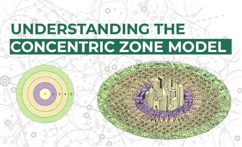
In order to understand and uncover something new about how a location came to be, a lot of research has been done with a lot of parameters. Fairy tales and stories from our elders, as well as scientific investigations, fall within this category. The study of the spatial arrangement of activities in a city, as well as urban form and how it influences spatial character, are two examples. The concentric zone model hypothesis, which organises activities in the form of concentric rings, is one such concept.


Based on observations and studies of numerous cities and urban expansion, these models and ideas were produced. Such research was done to better understand the spatial forms of major American and European cities including Chicago, Boston, New York, and London, among others. The findings were not applicable to all metropolitan settings, although they did function well in a few. Nonetheless, such study demonstrated a desire to learn more about how cities grew, how land use patterns shaped them, and what shaped them. Improvements continued, and greater results were achieved. Geographic location, economy, transportation, connection, city shape, and policies were added to the mix, resulting in a more complete picture and more accurate outcomes.


About the Author

Suksheetha Adulla is currently studying Architecture and Urban planning at Newcastle University, United Kingdom. She aspires to become an architectural designer with an intent to fuse her passion towards designing with affection towards environment and build a society in order to inspire, motivate and equip people on a greening journey with sophisticated civilization. She is a caffeine addict who loves playing basketball, reading books, and baking goodies.

Related articles

UDL Thesis Publication 2024

Curating the Best Thesis Projects Globally !

Leave a Reply

UDL Photoshop

Masterclass

Decipher the secrets of

Urban Mapping and 3D Visualisation

Session Dates

4th-5th May, 2024

Urban Design

Post-Thesis Opportunities and Resources

Join the largest social media community!

0 + K

Join Our WhatsApp Group

Recent Posts

Sign up for our Newsletter

“Let’s explore the new avenues of Urban environment together “

A Comprehensive Guide (Free E-book)

Post-Thesis Opportunities and Resources

Urban Design