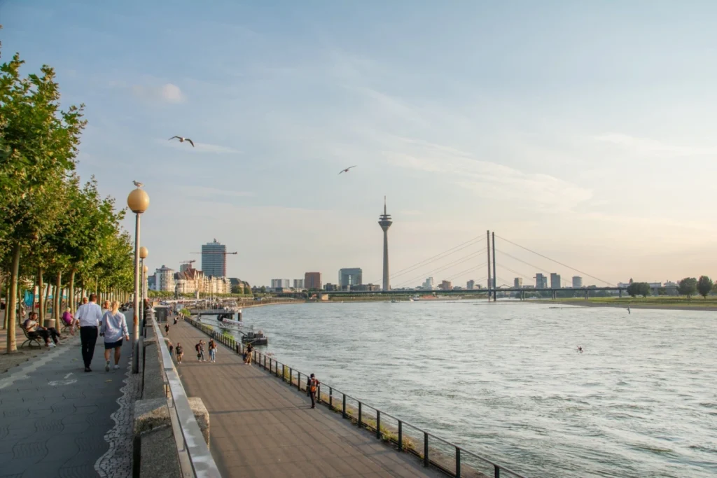
Once central to commerce and civic life, urban riverfronts were long neglected in the wake of industrialization. Today, cities around the world are reclaiming these vital edges, transforming them into sustainable, vibrant, and socially connected corridors. Modern riverfronts now serve as multifunctional spaces—linking people with nature, enhancing urban mobility, and confronting the escalating challenges of climate change. Guided by landscape urbanism and empowered by smart technologies, greenway corridors are evolving as resilient social connectors that foster civic identity, support biodiversity, and promote low-carbon lifestyles. Case studies like Shanghai’s West Bund Corniche and Chicago’s Riverwalk exemplify how post-industrial landscapes can be reimagined into inclusive, dynamic public realms that seamlessly weave together culture, ecology, and community.
Introduction: Recapturing the Riverfront in Urban Futures
The beginning of development and formation of cities urban riverfronts have played important role. These areas are place for commercial, transportation, socializing space, and creating urban life in terms of culture and economically viable. However, with the rise of industrialization and change in infrastructure the riverfronts become neglected, skipped, polluted, and physically cutted from the urban environment. Nowadays the paradigm has shifted and the idea of maintaining image of riverfronts for sustainable urban development as a critical location emerged.
The greenway riverfronts become innovative approach to sustain urban resilience which blending ecological restoration with social connectivity. These spaces bring people with water, nature, and each other as serves multifunctional corridors while adressing contemporary issues like climate change, urban heat island, and social fragmentation.
By reintegrating riverfronts with urban environment cities can advance their cultural and ecological potential, shaping once marginalized areas into vibrant, sustainable and accessible spaces.
This article traces the development of riverfront planning from traditional approaches to innovative techniques, emphasizing their pivotal role as transit corridors within integrated mobility networks. Such transformation not only revitalizes the environment but also enhances urban mobility, social inclusion, and economic opportunity.
Most of the riverfronts nowadays are the heritage of post-industrial periods, it has often characterized by the deteriorated landscapes, nehlected infrastructure, and environmental disasters. Converting these post-industrial riverfronts into resilient urban spaces is a major issue that cities worldwide are readdressed. Smith and Rojas (2022) underlined the growing adoption of nature-based solutions that combine flood reduction, habitat restoration, and urban green infrastructure to advance resilience. These methods move away from conventional hard-engineered fixes and towards softer, more flexible interventions like artificial wetlands, and floodable parks. These designs create areas for public leisure and biodiversity while assisting communities in improving water quality, absorbing storm surges, and lowering the risk of flooding. Furthermore, multifunctionality areas built to manage natural processes in addition to recreational, cultural, and transit functions which is encouraged by resilient riverside urbanism. In crowded urban settings with limited land and several conflicting applications, this multifunctionality is essential. Cities may improve the quality of life for its citizens and prepare for climate uncertainty by including resilience principles into riverfront planning. Additionally, resilient riverfronts promote community involvement and stewardship, creating a sense of collective accountability for the upkeep and management of these essential urban ecosystems.
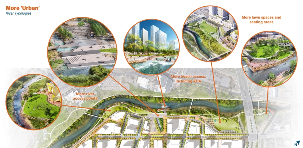
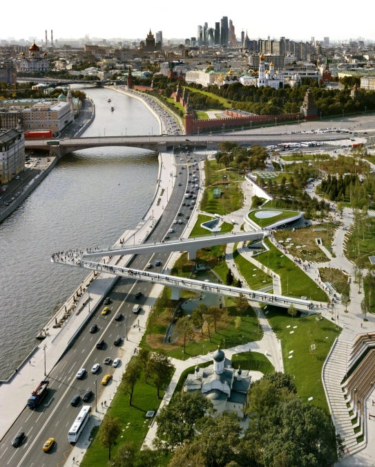
The River Mile: A Model for Urban Riverfront Development
Source: Website Link
Innovation through Smart Green Corridors on Forgotten Waterways
Riverfront planning has seen an increase interesting in smart city opinions, precisely with regard to reviving abandoned waterways. In order to establish smart ecological corridors that utilise technology and ecological design in a complementary manner, Yildirim and Cheng (2020) suggest a catalyst method. This strategy entails combining sensor networks and data collecting techniques into greenway infrastructure to keep an eye on environmental aspects including biodiversity, water quality, and usage models. Adaptive management is made possible by these data-driven platforms, which give communities and planners the ability to proactively address shifting social and environmental potentials. Furthermore, smart green corridors use modular designs and cutting-edge materials to improve sustainability and adaptability. For instance, native plants, energy-efficient lighting, and permeable pavements improve ecological performance while requiring less upkeep.
Activating abandoned waterways with smart corridors turns them into vibrant urban assets that support ecosystem services and enhance people’s health and well-being. By combining digital infrastructure and participatory management, this inventions goes beyond conventional greenway conceptions and harmonizes riverfront growth with more general smart city aims. Therefore, the smart corridor model offers cities a viable option to strike a balance between inclusive urbanism, technological progress, and ecological restoration.
Integrating Riverfront Greenways with Urban Transit Networks
Rather than being merely recreational routes, riverfront greenways are becoming essential parts of metropolitan transit and mobility networks. Greenways become efficient low-carbon mobility corridors when combined with bike-share programs, bus and rail transit hubs, and even maritime transit like ferries, according to Zawawi, Porter, and Ives (2020). By resolving last-mile connectivity issues that frequently prevent people from using public transportation, this integration makes multimodal travel smooth. Transit-oriented development (TOD), which encourages compact urban growth and lessens reliance on private vehicles, is supported when greenways are aligned with transit lines.
Additionally, riverfront transit corridors give underprivileged and marginalized communities fair access to services, jobs, and education. Greenway-transit integration improves urban liveability, eases traffic, and encourages active mobility, as planners in places like Seoul and Copenhagen have shown. Retrofitting current urban fabrics to facilitate such integration still presents challenges, but promising avenues are provided by advancements in technology, design, and legislation. All things considered, the transformation of riverfront greenways from solitary recreational routes to integrated transit corridors is a prime example of how sustainable urbanization can transform connection and mobility.
Walkability and Sustainability in River-Adjacent Urban Cores
Space limitations and conflicting land uses make it particularly difficult to integrate green space and sustainable mobility in densely populated city centers. According to Kara and Hsieh (2020), riverfront greenways have the ability to improve ecological functions, encourage walkability, and lessen urban heat in these settings. By creating microclimates along riverside corridors with vegetation buffers, permeable surfaces, and shade structures, pedestrians and bikers can have greater thermal comfort. Riverfronts that are walkable promote mode shifts from driving to active transportation, which is consistent with more general climate goals. Additionally, by acting as green lungs in densely populated regions, these corridors enhance air quality and offer urban wildlife habitats. Crucially, walkability promotes social inclusion by offering accessible pathways for a range of users, such as young people, the elderly, and those with impairments. Integrated design approaches that respect historical and cultural settings while striking a balance between recreational, ecological, and transportation purposes are essential to the success of urban core greenways.
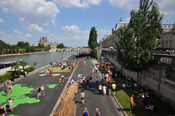
Berges de Seine, Paris, France, by Franklin Azzi Architecture. FRANKLIN AZZI ARCHITECTURE
Riverfronts as Vehicles for Infrastructure Revival
Old, neglected riverfront infrastructure, including abandoned ports, bridges, and railroad lines, can be found in many cities. In order to promote sustainability and heritage preservation, Torres (2023) investigates how these components might be repurposed as essential components of greenway networks. Through adaptive reuse, outdated infrastructure is converted into parks, bike lanes, and pathways that reestablish a community’s connection to the river. This strategy conserves embodied energy and reduces demolition trash, which is consistent with the ideas of the circular economy.Furthermore, maintaining industrial legacy gives riverfront greenways a distinct identity and richness of culture. The integration of historic infrastructure promotes multipurposeness by providing leisure and transit purposes as well as educational opportunities. Collaborations between planners, architects, historians, and community organizations are frequently necessary for successful projects. Integrative methods like these show that riverfront revitalization may creatively build upon the past while preserving it for future urban resilience.
Sustainable Model of Transit Networks through Greenways
A striking illustration of sustainable riverfront urbanism that combines multimodal transportation, public access, and ecological restoration is the Chicago Riverwalk. The transformation of the formerly contaminated industrial river corridor is documented by Urban Lab Chicago (2021) and features tiered, flood-responsive design that controls runoff while establishing welcoming areas for dining, strolling, and mingling. The Riverwalk improves environmental quality and cultural vibrancy by including permeable surfaces, native plants, and public art.
It is an essential component of Chicago’s mobility network because of its connections to bike infrastructure and transportation hubs. The multifunctionality of effective riverfront greenways is demonstrated by its tiered programming, which accommodates a variety of uses, from daily commuting to recreational pursuits and special events. The Chicago Riverwalk is a prime example of how community involvement and integrated planning can create resilient, welcoming, and visually appealing urban areas that concurrently advance social and environmental objectives (Urban Lab Chicago, 2021).
The Chicago River transforms into a vivid spectacle.
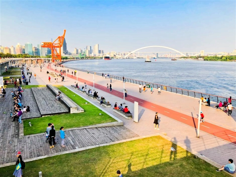
Shanghai West Bund Corniche – A Revitalization Case Study
An 8.5-kilometer section of the Xuhui District’s once-industrial Huangpu Riverfront is transformed into a lively, multipurpose public space by the West-Bund Corniche. Peter Verity’s proposal, which was further refined by landscape architect Hassell over 11.4 km of riverfront that opened in 2021, led the transition after an international design competition in 2008. In addition to enhancing resilience roots strengthen riverbanks, and “sponge city” planting absorbs floodwaters, the design preserves old trees and natural materials, honoring tradition. Grassy lawns, cafes, bike lanes, skate ramps, platforms, and a unique “activity table” along the river are examples of adaptable public areas that promote diverse community involvement.
An artistic cluster is fostered by the West-Bund Museum (a David Chipperfield-designed Centre-Pompidou satellite that opens in 2019), Long Museum, Yuz Museum, and the soon-to-be West-Bund Orbit. Additionally, the site incorporates low-energy and sustainable mobility systems: ecological corridors, public transportation connections, wind-optimized AI Tower & Plaza, pedestrian priority, and these elements lower heat islands and promote public health. It illustrates how industrial riverfronts in contemporary cities can be transformed into robust, easily accessible, and culturally rich greenways.
West Bund Corniche- The Place for Walking and Resting.
The intersection of sustainable mobility, social connectivity, and ecological restoration is embodied by riverfront greenways. These corridors are becoming pivotal transit routes within multimodal metropolitan networks rather than isolated recreational areas. Riverfronts provide crucial links that improve urban resilience, equity, and vitality by combining green infrastructure with walkability, bikeability, and public transportation. These designs are guaranteed to react to actual ecosystem dynamics and human behaviors thanks to theoretical developments and data-driven planning. Additionally, riverside identity and utility are enhanced by the adaptive reuse of industrial infrastructure. Exemplary initiatives that strike a balance between innovation and tradition, such as the Chicago Riverwalk, can serve as models for cities around the world. Ultimately, a potent tactic for creating connected, healthy, and lively urban futures is sustainable urbanization along riverfront transit corridors.
References
Zhou, Y., He, J., & Wang, Y. (2021). The Urban Riverfront Greenway: A Linear Attractor for Sustainable Urban Development. Sustainable Cities and Society, 72, 103030.
Smith, D., & Rojas, M. (2022). Resilient Urbanism: Bridging Natural Elements & Sustainable Structures in a Post-Industrial Urban Environment. Urban Ecosystems Journal, 25(3), 487–506.
Yildirim, A., & Cheng, J. (2020). A Catalyst Approach for Smart Ecological Urban Corridors at Disused Waterways. Landscape and Urban Planning, 200, 103822.
Lozano, M., & Becker, S. (2023). Riverfront Greenways and Urban Transit Corridors: Planning for Multimodal Mobility Networks. Journal of Transport and Urban Planning, 34(2), 89–105.
Kara, E., & Hsieh, P. (2020). Walkable and Sustainable City Centre Greenway Planning. Sustainable Urban Design Review, 8(2), 213–230.
Torres, M. (2023). Reviving Aging Cities’ Infrastructure: The Case of Riverfronts. Infrastructure and Urban Renewal Journal, 12(1), 36–49.
Urban Lab Chicago. (2021). The Chicago Riverwalk: Urban Sustainability Lessons. City Projects and Innovation, 14(3), 75–88.
Mendez, L. (2022). Urban design and rivers: A critical review of theories devising planning and design concepts to define riverside urbanity. Journal of Urban Studies, 59(4), 720–740.
West Bund Group. (n.d.). District overview. West Bund. Retrieved June 21, 2025, from https://www.westbund.com/en/index/ABOUT-WEST-BUND/Regional/District-Overview.html
Zawawi, A., Porter, N., & Ives, C. D. (2020). Greenways and sustainable urban mobility systems. (pp. 39–78)
Şeyma İncin
About the author
Seyma Incin is an urban planner with an interest in research and community development. She is passionate about creating inclusive, well-organized, and sustainable communities through education, participation, and thoughtful planning. Her work often focuses on understanding local needs and designing approaches that strengthen public well-being and social connection. Seyma is dedicated to supporting community-led initiatives and believes in the power of collaboration to build healthier, more resilient environments.
“Let’s explore the new avenues of Urban environment together “
We use cookies on our website to give you the most relevant experience by remembering your preferences and repeat visits. By clicking “Accept”, you consent to the use of all the cookies. Read More
This website uses cookies to improve your experience while you navigate through the website. Out of these, the cookies that are categorized as necessary are stored on your browser as they are essential for the working of basic functionalities of the website. We also use third-party cookies that help us analyze and understand how you use this website. These cookies will be stored in your browser only with your consent. You also have the option to opt-out of these cookies. But opting out of some of these cookies may affect your browsing experience.
Necessary cookies are absolutely essential for the website to function properly. These cookies ensure basic functionalities and security features of the website, anonymously.
Cookie
Duration
Description
cookielawinfo-checkbox-analytics
11 months
This cookie is set by GDPR Cookie Consent plugin. The cookie is used to store the user consent for the cookies in the category "Analytics".
cookielawinfo-checkbox-functional
11 months
The cookie is set by GDPR cookie consent to record the user consent for the cookies in the category "Functional".
cookielawinfo-checkbox-necessary
11 months
This cookie is set by GDPR Cookie Consent plugin. The cookies is used to store the user consent for the cookies in the category "Necessary".
cookielawinfo-checkbox-others
11 months
This cookie is set by GDPR Cookie Consent plugin. The cookie is used to store the user consent for the cookies in the category "Other.
cookielawinfo-checkbox-performance
11 months
This cookie is set by GDPR Cookie Consent plugin. The cookie is used to store the user consent for the cookies in the category "Performance".
viewed_cookie_policy
11 months
The cookie is set by the GDPR Cookie Consent plugin and is used to store whether or not user has consented to the use of cookies. It does not store any personal data.
Functional cookies help to perform certain functionalities like sharing the content of the website on social media platforms, collect feedbacks, and other third-party features.
Performance cookies are used to understand and analyze the key performance indexes of the website which helps in delivering a better user experience for the visitors.
Analytical cookies are used to understand how visitors interact with the website. These cookies help provide information on metrics the number of visitors, bounce rate, traffic source, etc.
Advertisement cookies are used to provide visitors with relevant ads and marketing campaigns. These cookies track visitors across websites and collect information to provide customized ads.


2 Comments
A clear and insightful analysis!
Thank you so much for your kind words! I’m glad you found the article insightful.