





















Artificial intelligence is increasingly influencing how architects and urban designers investigate sites, develop design alternatives, visualise proposals, analyse spatial data and communicate planning decisions. Tasks that previously required extensive manual modelling, image processing or repetitive calculations can now be supported by machine learning, generative design systems and AI-assisted software.
However, the integration of artificial intelligence into architectural practice raises a fundamental question: does AI improve the quality of design decisions, or does it primarily accelerate the production of design alternatives?
The distinction is important. A system capable of generating hundreds of building configurations does not automatically identify the most socially appropriate design. Similarly, an AI-generated architectural visualisation may communicate an attractive urban environment without accurately representing its dimensions, construction materials, accessibility or environmental performance.
The American Institute of Architects (AIA), in its 2026 guidance on artificial intelligence, emphasises that professional responsibilities such as contextual judgment, technical coordination, ethical decision-making and public welfare remain central to architectural practice.
For urban designers, these responsibilities extend beyond individual buildings. Urban projects require consideration of pedestrian movement, neighbourhood morphology, environmental conditions, infrastructure, land use, public spaces, governance and the experiences of different communities.
Artificial intelligence can assist with specific components of these processes, but its contribution depends on the problem being investigated and the reliability of the information provided.
It is also important to distinguish between different technologies commonly described as AI.
Generative design systems explore alternative configurations under defined constraints. Machine learning models identify statistical patterns or make predictions from training data. Generative image models produce visual representations based on prompts or references. Large language models assist with writing, programming, data interpretation and research workflows.
These technologies solve different problems and should not be evaluated using identical criteria.
This article examines fifteen AI-enabled tools relevant to architecture and urban design, covering early-stage site planning, building configuration, architectural visualisation, research assistance, geospatial analysis and participatory planning.
Rather than treating the tools as universally beneficial, the discussion considers their documented capabilities, practical applications, limitations and the circumstances in which conventional architectural or analytical methods remain preferable.
Site planning requires the evaluation of multiple interacting constraints, including plot geometry, building coverage, circulation, development capacity, environmental conditions and applicable planning regulations.
Traditionally, alternative configurations are developed through repeated modelling and calculation. Generative and AI-assisted design platforms can reduce some of this repetitive work by producing and comparing options according to specified parameters.
Nevertheless, the results are only as reliable as the constraints, geographic information and assumptions supplied to the software.
Website: https://www.autodesk.com/products/forma-site-design/overview
Best for: Urban massing, site feasibility, early-stage environmental analysis and comparative development scenarios.
Autodesk Forma Site Design is a cloud-based design and analysis platform intended for early architectural and site-planning workflows.
According to Autodesk’s official product documentation, the platform combines contextual geographic information, three-dimensional massing, layout automation and environmental analysis within a shared design environment.
Users can construct or import building configurations, study the surrounding context and compare alternative proposals against selected performance indicators.
Its documented analytical functions include sunlight hours, daylight potential, shadow studies, wind conditions, noise, microclimate and solar energy potential.
A particularly relevant distinction is that Forma’s rapid wind and noise analyses use machine learning predictions, while more detailed simulation options are available for certain assessments. Autodesk explicitly differentiates these methods in its wind-analysis documentation.
For urban designers, Forma can support the early examination of building massing and open-space arrangements.
Consider a hypothetical residential development involving several building blocks around shared courtyards. Designers could compare alternative configurations to investigate how building orientation, height and spacing influence modelled sunlight exposure and pedestrian-level wind conditions.
This comparison may help identify options requiring additional assessment before detailed design.
Forma is particularly relevant for evaluating development density, exploring alternative building arrangements, examining the relationship between massing and outdoor environmental conditions, and communicating preliminary scenarios.
The platform also supports interoperability with other design environments, including Revit and Rhino, as described in Autodesk’s training resources.
An important limitation is that rapid AI-based analysis is not equivalent to a detailed, independently validated environmental simulation.
The reliability of results depends on the geometry, surrounding context, weather data and assumptions used.
Similarly, a massing arrangement that performs well for sunlight may not provide the most effective pedestrian network, socially inclusive public space or appropriate response to local urban morphology.
Forma should therefore support preliminary comparative assessment rather than function as the sole basis for planning approval or detailed environmental conclusions.
Website: https://www.testfit.io/
Best for: Development feasibility, residential planning, parking arrangements, building capacity and land-development scenarios.
TestFit focuses on automating aspects of real-estate development feasibility.
Its platform combines site planning, building configuration, development metrics and financial analysis to help users examine alternative layouts.
According to the official TestFit Site Solver documentation, users can define site boundaries, configure building typologies, incorporate certain geographic constraints and generate design alternatives based on parameters such as development intensity, parking requirements and building configuration.
This makes TestFit relevant to urban development projects where spatial capacity and financial feasibility are closely connected.
For example, a developer evaluating a mixed-use site may need to understand how changes in building coverage or parking requirements influence the achievable floor area.
TestFit can automate alternative configurations and update associated development metrics.
The platform also supports export and interoperability with established architectural software, including Revit and SketchUp.
For architects and urban designers, TestFit can be useful in preliminary land-development studies, mixed-use development assessments, parking optimisation and rapid comparison of building typologies.
It may also support conversations between architects, developers and financial consultants during early feasibility assessment.
A technically feasible development scheme is not necessarily a desirable urban design proposal.
Optimisation objectives such as development yield, parking provision or construction efficiency may underrepresent public-space quality, pedestrian comfort, neighbourhood identity and distributive equity.
Some of TestFit’s contextual datasets and regulatory functions are geographically specific. A project in India, for example, requires verification against the applicable local development-control regulations rather than assuming that built-in regulatory parameters are directly transferable.
The strongest use of TestFit is as a feasibility-testing environment whose results are subsequently evaluated through architectural design, planning analysis and local regulatory review.
Website: https://www.finch3d.com/
Best for: Floor-plan generation, building configuration, repetitive design tasks and computational architectural workflows.
Finch is an AI-enabled building-design platform focused on generating and refining architectural configurations.
The official Finch website describes tools for encoding organisational design standards, exploring alternatives and generating floor plans and building information modelling geometry.
Its approach differs from purely image-based design generation.
Rather than producing only an attractive representation, Finch aims to work with building layouts, room arrangements, area calculations and design constraints.
This makes the software relevant to architectural projects involving repeated or systematically organised spaces, such as residential developments, office buildings and certain institutional building types.
For example, an architectural team developing a residential complex may need to compare different unit mixes, circulation arrangements and floor-plate configurations.
Finch can support iterative testing of these arrangements while updating associated spatial information.
Such a workflow can help identify promising configurations for further architectural development.
Finch may support repetitive floor-plan generation, alternative unit configurations, building-area assessment and coordination between early design exploration and subsequent modelling.
Its usefulness is greatest when the requirements can be translated into clearly defined parameters and reusable design rules.
An automatically generated floor plan should not be treated as a fully coordinated or code-compliant construction document without independent verification.
Circulation requirements, fire safety, accessibility, structural coordination, daylight provision and local regulatory standards require professional review.
Moreover, highly contextual architectural projects may not be adequately described through generic space-planning rules.
Finch is consequently better understood as a design-assistance and configuration system than as an autonomous architectural designer.
Website: https://www.archistar.ai/
Best for: Property development assessment, generative building concepts and planning-constraint exploration.
Archistar combines property technology, generative design and AI-assisted development analysis.
The company’s integration with Autodesk Forma is documented in the Autodesk Technology Partner Ecosystem.
The integration supports the generation of three-dimensional building configurations using site-specific parameters, including setbacks, heights, zoning considerations and other design constraints.
For urban designers, Archistar represents a broader shift toward linking geographic and regulatory information with preliminary building design.
A site-development exercise might involve comparing alternative built forms under a specified building-height limit, maximum coverage or setback requirement.
Automating parts of this process can assist designers in identifying which combinations deserve more detailed investigation.
Archistar is relevant to early property feasibility, building-envelope studies, residential development scenarios and preliminary comparisons of development controls.
The integration with Forma also creates opportunities for further investigation of massing alternatives within a wider site-planning environment.
Development-control regulations are jurisdiction-specific and may involve exceptions, overlays, discretionary approvals and requirements that cannot be fully captured through simplified parameters.
A generated proposal should therefore be checked against the current statutory regulations applicable to the project.
Automated feasibility also does not establish architectural quality, urban compatibility or infrastructure adequacy.
The broader implication of these four tools is that AI-assisted site planning can accelerate the exploration of defined possibilities, but it cannot independently decide which development priorities should govern an urban project.
Architectural visualisation is among the most visible applications of generative AI.
Image-generation systems can produce architectural scenes, facade variations, landscape concepts and atmospheric representations from text descriptions, sketches or model views.
However, photorealism does not establish geometric or technical accuracy.
The distinction is especially important in professional architectural communication. A generated image may introduce windows, structural members, vegetation or public-space elements that are absent from the source model.
These tools are therefore most defensible when their visual output is identified as conceptual rather than as a verified representation of a final design.
Website: https://www.chaos.com/ai-rendering
Best for: Architectural concept renders, facade studies, material exploration and model-based visualisation.
Veras is an AI architectural visualisation platform associated with EvolveLAB and the Chaos ecosystem.
The official Chaos documentation identifies integration with applications including Revit, SketchUp, Rhino, Archicad and Autodesk Forma.
Its central advantage is the ability to use an existing architectural model or design image as the starting point for generative visual exploration.
Instead of constructing a complete conventional rendering workflow for each conceptual option, designers can investigate different materials, environmental conditions and architectural expressions.
For example, an architect developing a community facility might create a basic three-dimensional model and use Veras to explore alternative facade materials and landscape treatments.
The underlying model provides a reference, while AI generation produces visual variations.
Veras is useful for early facade studies, material comparisons, preliminary client presentations and architectural ideation.
It may also support rapid exploration of visual directions before a detailed rendering model is developed.
Generated images can depart from the underlying model, even when model geometry is used as a reference.
The output should be checked for altered openings, inaccurate structural components, inconsistent material relationships and other design changes.
An AI render is not proof that the represented construction is feasible.
For final documentation, dimensional accuracy and visual consistency should be maintained through appropriately controlled modelling and rendering processes.
Website: https://www.lookx.ai/
Best for: Architectural concept images, sketch-to-render workflows, stylistic exploration and preliminary visual communication.
LookX AI is an architectural and interior-design-focused generative visualisation platform.
According to its official product description, the platform supports text- and sketch-based image generation, reference-image workflows, image enhancement and integrations with design software.
Its architectural focus makes it relevant to concept-stage projects where visual identity and atmosphere are being investigated.
For example, an urban design studio might use LookX to explore different architectural expressions for a public market, community building or mixed-use precinct.
A conceptual massing diagram could be used as a visual reference while prompts describe possible material characteristics, shading elements or urban settings.
The resulting images may help communicate alternative design intentions.
LookX is suitable for initial architectural ideation, preparing visual references, comparing facade expressions and exploring presentation styles.
It may be particularly useful when conventional detailed rendering would be disproportionate to the early stage of design development.
The generation of visually convincing architectural imagery does not establish that the proposed design responds appropriately to the site.
A model may introduce construction details, building proportions or environmental features that were not specified.
For heritage-sensitive or culturally specific projects, generated imagery also requires careful review to avoid historically inaccurate or contextually inappropriate representations.
The resulting images should be clearly identified as design concepts.
Website: https://www.adobe.com/products/firefly.html
Best for: Image editing, visual alternatives, presentation refinement and controlled generative image production.
Adobe Firefly is Adobe’s generative AI platform, with features integrated into applications such as Photoshop.
The official Adobe Generative Fill documentation describes the use of text instructions to add, remove or modify image content, along with tools for expanding compositions.
These capabilities can support architectural presentation workflows in which designers need to explore visual changes without reconstructing an entire image.
For example, a designer may have a verified architectural render showing the proposed building geometry but wish to explore different atmospheric conditions or illustrative landscape treatments.
Generative editing can provide quick alternatives for internal design review.
The distinction between image editing and geographic or architectural data modification should remain explicit.
Firefly can assist with presentation backgrounds, visual-composition development, image cleanup and exploratory variations of architectural imagery.
Its integration with established Adobe workflows makes it relevant to architects already using Photoshop for architectural boards and urban mapping.
AI editing can introduce objects that appear plausible but do not exist in the approved design.
A generated tree canopy, pedestrian area or facade component should not be represented as a confirmed project feature unless it is part of the design.
Adobe’s Firefly FAQ provides information on commercial-use conditions, which should be reviewed for the particular feature and model used.
Copyright, image provenance and permissions for uploaded reference material remain important considerations.
Website: https://www.midjourney.com/
Best for: Concept imagery, architectural atmospheres, design narratives and speculative urban scenarios.
Midjourney is a generative image platform that can create images from text instructions and visual references.
Its official Image Prompts documentation explains how reference images can influence composition, colours and subject matter.
Additional editing functionality allows users to modify selected areas or extend an existing image, as described in the Midjourney Editor documentation.
For architecture and urban design, Midjourney can support the exploration of visual concepts that are difficult to communicate using preliminary drawings alone.
It may be used to investigate atmospheric possibilities for waterfronts, public spaces, architectural forms or speculative future scenarios.
However, its role differs fundamentally from that of a parametric building model or spatial-analysis platform.
Midjourney may be useful for conceptual moodboards, communicating speculative design intentions, exploring material character and generating visual references for design discussion.
Generative images are not reliable architectural drawings.
A visually convincing perspective may contain inconsistent dimensions, impossible construction details, misleading relationships between buildings or non-existent infrastructure.
The use of image references does not guarantee faithful reproduction of the source geometry.
Generated images should not be used as factual documentation of real urban conditions.
For professional practice, these outputs are best treated as preliminary visual explorations that require translation into verifiable design information.
The central distinction across these four tools is that AI visualisation expands the range of images a designer can explore, but it does not replace the modelling, technical verification or professional judgment required to establish an architectural proposal.
Not every significant use of artificial intelligence in architecture involves generating buildings or images.
Research, data preparation, programming, document analysis and repetitive administrative tasks can consume substantial time within architectural and urban design projects.
Large language models and AI coding assistants can support these activities by helping users structure information, develop scripts, examine documents and troubleshoot technical workflows.
Their usefulness, however, depends on the quality of the instructions and the extent to which their outputs can be independently verified.
Website: https://chatgpt.com/
Best for: Research support, GIS scripting, data interpretation, document preparation and workflow automation.
ChatGPT is an AI assistant developed by OpenAI.
Its capabilities include working with uploaded documents and structured data, assisting with code, answering questions and producing written or analytical outputs.
According to OpenAI’s official data-analysis documentation, ChatGPT can inspect uploaded datasets and help users generate tables, calculations and charts.
For architects and urban designers, the most useful applications extend beyond general brainstorming.
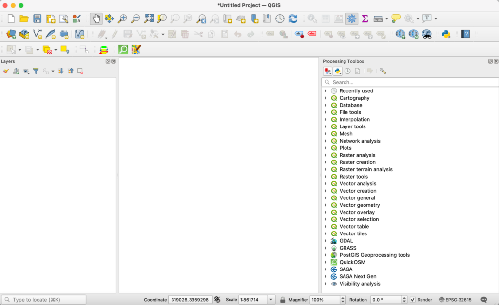
A GIS researcher may use ChatGPT to draft PyQGIS scripts for repetitive processing operations, develop Python code for spatial-data cleaning or troubleshoot errors in an existing script.
Similarly, an urban researcher could use it to structure interview data, draft a coding framework or assist with the preparation of descriptive statistics.
A hypothetical workflow could involve preparing a spreadsheet containing observations of pedestrian crossings.
The researcher might use ChatGPT to develop code that groups observations by crossing type, calculates descriptive summaries and exports the results in a format suitable for GIS mapping.
The calculations should then be inspected against the original data.
ChatGPT is relevant to scripting, documentation, developing methodological checklists, reviewing calculations and assisting with research writing.
It can also support the development of repeatable GIS workflows when the user provides the relevant software version, input schema and expected output.
ChatGPT can generate incorrect code, invent references or misinterpret the structure of uploaded data.
Its output should not be accepted as verified research evidence without inspecting the original sources and calculations.
For urban analysis, scripts should be executed on test datasets, checked for coordinate-system errors and compared with known results where possible.
Sensitive project information and unpublished research data should be handled according to applicable institutional and contractual requirements.
Website: https://claude.ai/
Best for: Long-document review, research synthesis, coding assistance and structured project workflows.
Claude is an AI assistant developed by Anthropic.
Its documented features include working with project knowledge, analysing documents and producing editable outputs.
According to Anthropic’s documentation on Claude Projects, users can create workspaces containing documents and contextual instructions.
Claude also offers an Artifacts environment for developing documents, code and interactive outputs, as described in the official Claude Help Center.
These capabilities may be useful for architectural and urban research involving multiple reports, design briefs or technical references.
For example, a researcher reviewing a municipal development plan could use Claude to organise the document into thematic categories relating to transport, housing, infrastructure and open-space policy.
It could also assist in drafting a structured comparison between successive policy documents.
The usefulness of this process depends on the researcher’s ability to verify whether the generated summary accurately represents the source.
Claude may support research-note organisation, technical-document review, programming assistance and preparation of structured analytical workflows.
It can be particularly useful when the task involves interpreting relationships between several documents or developing reusable project instructions.
A model-generated document summary may omit qualifications, misinterpret technical terminology or combine claims that originate from different sources.
For academic writing, all important assertions require verification against the cited material.
Similarly, software scripts and analytical calculations should be tested independently.
Claude should be treated as an assistant in the research process rather than as an authoritative source.
Website: https://github.com/features/copilot
Best for: Programming, script development, code troubleshooting and repetitive technical automation.
GitHub Copilot is an AI coding assistant integrated with software-development workflows.
The official GitHub documentation describes capabilities for writing, understanding, reviewing and modifying code.
Although GitHub Copilot is not specifically developed for architecture, it can support computational design and geospatial programming.
Architects working with Rhino, Grasshopper, Dynamo or Python-based workflows may use AI coding assistance to develop and refine scripts.
Urban designers using QGIS or spatial Python libraries may also benefit from assistance with data conversion, geometric operations and automated map production.
For example, a research team might need to process multiple GeoPackage layers, calculate selected geometric attributes and export a consistent series of maps.
A coding assistant could help draft the required Python functions and identify errors during development.
GitHub Copilot may support PyQGIS development, geospatial Python workflows, repetitive data-processing operations and computational design scripting.
Its value is greatest when users already understand the underlying programming language and can evaluate the suggested code.
AI-generated code can contain logical mistakes even when it executes successfully.
In geospatial analysis, a script may use an inappropriate coordinate reference system, calculate area in incorrect units or perform a spatial join that produces misleading results.
Consequently, successful execution is not proof of analytical correctness.
Generated scripts should be version-controlled, tested against known datasets and reviewed before being used for research or professional decisions.
These three assistants illustrate a different form of AI integration: rather than replacing design tools, they help users interact more effectively with data, documents and programming environments.
Geospatial analysis offers some of the most technically significant applications of machine learning in urban research.
Satellite imagery, aerial photography, LiDAR, geographic networks and spatial databases contain large amounts of information that can be analysed using trained models.
Machine learning can help identify buildings, classify land cover, detect spatial patterns and estimate relationships among geographic variables.
Unlike generative architectural imagery, these applications typically produce spatial datasets or predictive outputs that can be evaluated using quantitative methods.
Nevertheless, model accuracy depends on training data, geographic context, spatial resolution and independent validation.
Website: https://www.esri.com/en-us/arcgis/products/arcgis-pro/overview
Best for: Object detection, spatial prediction, geospatial classification and advanced geographic analysis.
ArcGIS Pro includes GeoAI capabilities integrating machine learning and deep learning with geographic information.
According to the official ArcGIS Pro GeoAI documentation, GeoAI can support the extraction of geographic information from imagery and other datasets, as well as classification, prediction and spatial-pattern analysis.
The GeoAI toolbox includes tools for imagery analysis, feature and tabular data, text analysis, embeddings and time-series applications.
For urban research, these capabilities may support the extraction of building features from imagery or the modelling of spatial patterns using relevant geographic variables.
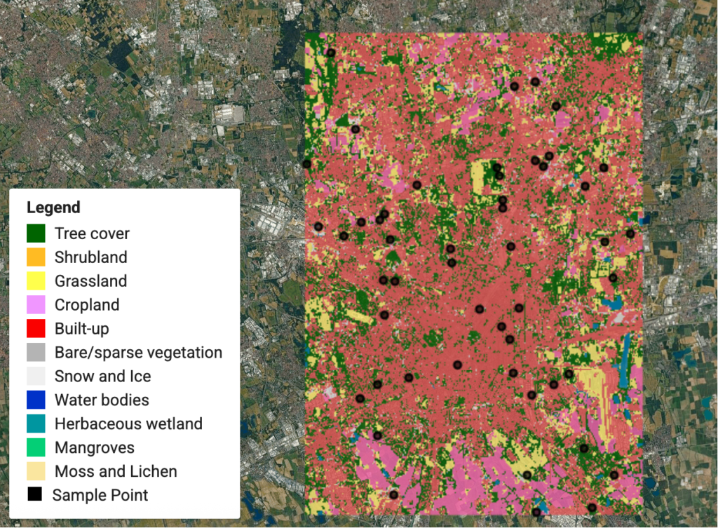
Consider a hypothetical study investigating the distribution of urban tree cover.
A research team might use suitably trained imagery-analysis models to identify vegetation-related features.
The resulting spatial data could then be examined in relation to neighbourhood boundaries, road networks or land-use categories.
ArcGIS Pro GeoAI is relevant to large spatial datasets, imagery classification, feature extraction and prediction tasks that require integration with an established GIS environment.
A pretrained model developed using one geographic environment may not perform equally well in another.
Differences in roof materials, street morphology, vegetation characteristics, imagery resolution and seasonal conditions can affect predictions.
Spatial machine-learning workflows also require careful attention to training and validation procedures.
The ArcGIS documentation notes that relevant deep-learning libraries must be installed for GeoAI tools requiring them.
For defensible research, model outputs should be validated using independent reference observations and clearly documented performance measures.
Website: https://mapflow.ai/
Best for: Satellite-image interpretation, building-footprint extraction, road mapping and preliminary urban inventories.
Mapflow is a geospatial AI platform developed for extracting geographic features from satellite, aerial and drone imagery.
According to the official Mapflow documentation, its models can identify features such as building roofs, roads and vegetation and return results as editable vector layers.
Mapflow can be used through a web platform, an API and a QGIS plugin.
The integration with QGIS is particularly relevant to urban designers who already use GIS for spatial analysis and cartography.
For example, a researcher studying urban expansion may need to prepare building-footprint datasets for several neighbourhoods.
An AI extraction process could provide an initial set of polygons derived from suitable imagery.
Those polygons could then be checked, corrected and used in subsequent GIS operations.
Mapflow can support preliminary building inventories, road-network extraction, vegetation mapping and the preparation of spatial datasets from imagery.
It may reduce some manual digitisation work when imagery quality and model performance are suitable.
Automatically extracted building polygons may contain false detections, omissions or incorrect boundaries.
Roofs do not always correspond exactly to ground-level building footprints, while shadows, dense tree cover and adjoining structures can complicate detection.
AI-extracted road geometry also requires checking before use in network-based accessibility calculations.
The availability of high-quality source imagery and the licensing conditions of that imagery must be considered.
The resulting dataset should be treated as a model-derived geographic product requiring verification rather than as an authoritative cadastral or engineering survey.
Website: https://earthengine.google.com/
Best for: Land-cover classification, urban-growth analysis, vegetation mapping and large-scale remote-sensing workflows.
Google Earth Engine is a cloud-based geospatial analysis platform providing access to extensive Earth-observation datasets and processing capabilities.
It is important to distinguish the platform itself from its machine-learning components.
Earth Engine is not exclusively an AI application. It supports conventional remote-sensing and geospatial operations alongside machine-learning methods.
According to the official Google Earth Engine machine-learning documentation, the platform provides tools for supervised and unsupervised classification and regression.
Its supervised-classification documentation describes algorithms including Random Forest, Classification and Regression Trees and Support Vector Machines.
For urban designers, these tools are useful when working with satellite imagery to investigate changing urban land cover.
For example, researchers could classify appropriate satellite imagery to distinguish broad categories such as built-up surfaces, vegetation and water.
Repeated classifications may support investigation of changing spatial patterns.
However, meaningful temporal comparison requires consistency in data preparation, classification definitions and accuracy assessment.
Earth Engine is useful for urban-growth mapping, broad land-cover analysis, vegetation monitoring and comparative environmental studies.
The platform is particularly relevant to projects covering large geographic extents or requiring repeated image processing.
Classification results are sensitive to training samples, spectral characteristics, sensor properties and spatial resolution.
A satellite-derived built-up class cannot automatically distinguish building use, population density or development legality.
Likewise, vegetation classification does not establish actual public-space accessibility.
Google’s documentation distinguishes built-in traditional machine-learning methods from more complex deep-learning workflows, which may require external frameworks.
A reliable research workflow should include independent validation, assessment of classification errors and explicit documentation of the imagery and algorithms used.
Together, these three platforms demonstrate how AI can contribute directly to geographic evidence production. Their analytical value depends less on visually impressive outputs than on measurable accuracy, appropriate spatial resolution and repeatable processing methods.
Artificial intelligence is also entering a different area of urban practice: the communication of possible futures with residents, communities and other stakeholders.
Traditional participation methods often involve maps, questionnaires, public meetings, drawings and design workshops.
Generative visualisation can supplement these methods by allowing participants to see hypothetical changes to familiar places.
However, visual participation should not be confused with representative democratic decision-making.
AI-generated images may encourage discussion, but participation remains dependent on who is invited, who can access the technology and how the resulting opinions influence actual decisions.
Website: https://site.urbanistai.com/
Best for: Public-space workshops, participatory design, visual scenario exploration and stakeholder communication.
UrbanistAI is a generative AI platform developed for participatory urban planning and collaborative design.
According to the official UrbanistAI platform description, it provides tools for collaborative ideation, visualising design possibilities and supporting public engagement.
Its approach differs from conventional AI architectural rendering because the intended users may include residents and non-professional participants rather than only trained designers.
For example, a local authority examining the redesign of a neighbourhood square might organise a workshop in which participants discuss potential improvements.
Generative tools could help visualise alternative arrangements of seating, planting, pedestrian space and other urban elements.
These images may create accessible discussion material for participants who are unfamiliar with technical architectural drawings.
The platform also supports mapping-based engagement and different modes of collaborative participation.
UrbanistAI may support public-space discussions, urban-design charrettes, educational workshops and visual communication of possible interventions.
Its usefulness lies in creating opportunities for dialogue around alternatives rather than automatically determining the preferred design.
AI-assisted visualisation cannot guarantee inclusive participation.
People who are absent from a workshop, lack digital access or are uncomfortable with image-based interfaces may remain underrepresented.
Furthermore, generative images may introduce unrealistic design elements or conceal constraints relating to cost, maintenance, accessibility or engineering feasibility.
Visual preference should therefore be distinguished from demonstrated public need.
A robust participatory process should combine visual exploration with representative engagement methods, accessible communication, documented feedback and transparent decision-making.
There is also a risk that attractive generated images may frame the discussion around aesthetic preferences while neglecting conflicts over land, mobility, affordability or resource distribution.
For urban designers, AI-assisted participation is most credible when it broadens the forms of expression available to communities without displacing established processes of consultation, negotiation and accountability.
The fifteen tools discussed in this article demonstrate that artificial intelligence is not a single architectural technology but a collection of different systems that can support specific parts of the design and research process.
Autodesk Forma Site Design, TestFit, Finch and Archistar assist with early-stage site planning, feasibility and building configuration. Their principal contribution is the ability to explore alternatives under defined parameters, rather than independently establish the most appropriate design.
Veras, LookX, Adobe Firefly and Midjourney support architectural visualisation and conceptual exploration. These tools can expand the range of possible visual directions, but their images require careful interpretation because visual realism does not guarantee geometric accuracy or construction feasibility.
ChatGPT, Claude and GitHub Copilot provide assistance with writing, coding, research organisation and repetitive technical operations. Their outputs can support professional workflows when source information, calculations and scripts are independently reviewed.
ArcGIS Pro GeoAI, Mapflow and Google Earth Engine extend machine-learning methods into spatial-data extraction, geographic classification and environmental analysis. Their usefulness depends on reliable imagery, appropriate models, independent validation and transparent reporting of uncertainty.
UrbanistAI illustrates the potential for generative AI to supplement participatory planning. However, the legitimacy of planning decisions continues to depend on representative consultation, public accountability and a meaningful understanding of local conditions.
For architects and urban designers, the critical challenge is therefore not to adopt as many AI tools as possible. It is to establish where AI contributes demonstrable value, where its outputs remain uncertain and where professional interpretation cannot be delegated.
This requires a disciplined workflow in which the design problem is defined before the tool is selected, input data are verified, generated outputs are critically examined and final decisions are supported by appropriate technical and contextual evidence.
It also requires transparency. Clients, reviewers and communities should be able to distinguish between observed conditions, modelled predictions, speculative visualisations and approved design proposals.
The professional guidance of the American Institute of Architects reinforces the continuing importance of human expertise, contextual understanding and ethical responsibility as AI becomes more widely used in architectural practice.
The most significant contribution of artificial intelligence to architecture and urban design may ultimately be its capacity to expand the range of questions that designers can investigate.
Whether that potential produces better buildings and cities depends not on the sophistication of the algorithms alone, but on the quality of the evidence, the relevance of the design objectives and the judgment of the people using them.
Urban Mapping, Analysis and Representation
Session Dates
Stay updated on workshops, design tools, and calls for collaboration
“Let’s explore the new avenues of Urban environment together “
| Cookie | Duration | Description |
|---|---|---|
| cookielawinfo-checkbox-analytics | 11 months | This cookie is set by GDPR Cookie Consent plugin. The cookie is used to store the user consent for the cookies in the category "Analytics". |
| cookielawinfo-checkbox-functional | 11 months | The cookie is set by GDPR cookie consent to record the user consent for the cookies in the category "Functional". |
| cookielawinfo-checkbox-necessary | 11 months | This cookie is set by GDPR Cookie Consent plugin. The cookies is used to store the user consent for the cookies in the category "Necessary". |
| cookielawinfo-checkbox-others | 11 months | This cookie is set by GDPR Cookie Consent plugin. The cookie is used to store the user consent for the cookies in the category "Other. |
| cookielawinfo-checkbox-performance | 11 months | This cookie is set by GDPR Cookie Consent plugin. The cookie is used to store the user consent for the cookies in the category "Performance". |
| viewed_cookie_policy | 11 months | The cookie is set by the GDPR Cookie Consent plugin and is used to store whether or not user has consented to the use of cookies. It does not store any personal data. |