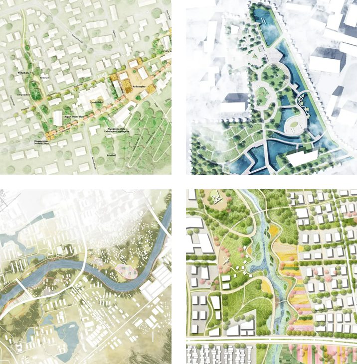
AMRUT 2.0 GIS-based master plan map layers for an Indian town

A master plan becomes consequential when it changes a decision: where housing is permitted, which neighbourhood receives infrastructure, how a drainage corridor is protected, or whether development can proceed without transferring costs to surrounding communities. A more detailed map can support these decisions, but it cannot make them accountable by itself.

India’s GIS-based master-planning programme should be assessed against this distinction. Under AMRUT 2.0, the government is extending geospatial planning support to Class-II towns, building on the earlier AMRUT initiative for larger cities. The programme combines spatial databases, master-plan preparation and institutional capacity building, rather than treating satellite imagery as a complete planning solution. Its formal scope is established in the AMRUT 2.0 GIS master-planning sub-scheme guidelines.

The central argument of this article is that the programme’s most valuable contribution could be the connection between land-use regulation and infrastructure decisions. Achieving that connection requires more than producing georeferenced zoning maps. It requires reliable field information, explicit statutory status, maintained databases and institutions capable of explaining how spatial evidence influenced a decision.

The discussion therefore separates verified programme outputs from anticipated benefits. It examines the programme’s scope, the production of planning evidence, the relationship with water security, implementation lessons from Kerala and an institutional comparison with Singapore.

1. Understanding the Programme Without Confusing Maps, Plans and Outcomes

The original AMRUT GIS initiative and the AMRUT 2.0 sub-scheme are related but distinct. The Town and Country Planning Organisation describes the earlier initiative as a centrally funded programme approved in October 2015 for GIS-based master or development plans in 500 AMRUT cities. Its components included urban databases, plan formulation under the relevant state legislation and capacity building, according to the TCPO programme description.

AMRUT 2.0 extends this approach principally to towns with populations of 50,000–99,999. The published sub-scheme guidelines initially proposed coverage of 675 towns, with specified flexibility for hilly and northeastern states and Union Territories. These are programme-design figures, not a current completion count (sub-scheme guidelines).

A later parliamentary reply, published on 10 August 2026, reported the following position:

ProgrammeReported coverageFinal geospatial databasesDraft master plans preparedMaster plans finalised
Original AMRUT GIS sub-scheme461 cities onboarded437404292
AMRUT 2.0 Class-II town sub-scheme875 towns covered10013693

Source: Ministry of Housing and Urban Affairs, “GIS-Based Urban Planning & Modernisation of Master Plans,” 10 August 2026. The reply also reported draft geospatial databases for 399 AMRUT 2.0 towns.

These figures require disciplined interpretation. The later coverage figure should not be replaced with the initial guideline target. Conversely, the difference between the two figures does not, by itself, explain how the programme expanded. That would require the relevant approvals and town lists.

More fundamentally, a completed database, a draft plan and a finalised plan are different administrative products. A database describes spatial features and their attributes. A draft plan proposes future arrangements. A finalised plan has advanced further through the planning process, but its precise legal status should still be checked against the applicable approval or notification record.

The table also should not be read as a simple conversion funnel. Without town-level records, one cannot assume that every reported category refers to an identical cohort progressing through identical stages. Nor can the number of finalised plans establish how effectively their provisions are being implemented.

The appropriate interpretation is therefore narrower than a claim of urban transformation: India is building a larger institutional and informational base for statutory planning. Whether this changes development patterns remains an empirical question. Evaluation should follow the chain from database quality to adopted provisions, funded projects and observable outcomes, rather than treating the production of a digital plan as the end of reform.

Suggested photograph: Aerial view of Kothamangalam’s buildings, streets and vegetation, illustrating the settlement detail that town planning must interpret.

Image link: https://upload.wikimedia.org/wikipedia/commons/d/dc/Aerial_view_of_kothamangalam.jpg

Suggested caption: Town-scale planning must connect mapped buildings and streets with infrastructure, environmental conditions and local needs; this photograph is contextual, not evidence of a completed AMRUT plan.

Credit: Cristygarna, Wikimedia Commons source, CC BY-SA 4.0. Credit the creator, link the licence, identify modifications and share adaptations under the same or a compatible licence.

2. Turning Geospatial Data into Defensible Planning Evidence

The technical change introduced by GIS is significant, but its significance should be expressed accurately. A GIS-based plan can organise spatial features together with information about their characteristics. Its analytical value depends on the quality and meaning of those attributes, not simply on the visual precision of the base map.

The government’s August 2026 account identifies satellite-derived mapping at 1:4,000 and drone or UAV mapping at 1:1,000 within the AMRUT 2.0 approach (MoHUA parliamentary reply). These are mapping scales, not statements of satellite pixel size or guarantees of cadastral accuracy.

The earlier AMRUT workflow provides a useful explanation of why fieldwork remains essential. NRSC describes preparing base maps, transferring them to urban local bodies for ground verification and attribute collection, and incorporating the returned information into final databases. Its urban applications documentation therefore presents database creation as an iterative institutional process, rather than a one-way delivery of remotely sensed information.

This distinction has practical consequences. An identifiable building footprint does not establish its occupancy, tenure, structural condition or permitted use. A mapped road does not establish whether pedestrians can use it safely. A visible waterbody does not reveal its seasonal storage, pollution load or hydraulic connection to surrounding land.

These limitations suggest a quality-control approach for planning authorities. Each important layer should record its source, observation date, verification method and responsible custodian. Where information is incomplete, the database should preserve that uncertainty. An explicit “not verified” attribute is more defensible than an apparently precise classification inferred without adequate evidence.

Existing conditions also need to remain distinguishable from proposals and legal designations. Existing commercial activity, proposed commercial zoning and legally permitted commercial use are not interchangeable. Combining them into a single undifferentiated layer would make the map easier to display but harder to use responsibly.

The same principle applies to scenario analysis. Consider a hypothetical proposal to accommodate additional housing. A defensible comparison would examine alternatives against common assumptions about household growth, infrastructure demand, accessibility and environmental constraints. If one alternative is assessed using current network capacity while another assumes unfunded upgrades, the resulting comparison is methodologically unequal.

GIS can make such assumptions spatially explicit. It cannot determine which assumptions are acceptable. That remains a planning judgement requiring disclosure and review.

A strong deliverable should consequently include more than a printable land-use map. Authorities should seek editable datasets, metadata, documented classifications, a record of corrections and reproducible analytical procedures. These are recommendations for operational quality, not claims that every participating town already meets them. Their purpose is to ensure that the plan can be questioned, revised and used after the original consultant’s assignment ends.

Suggested photograph: A high-resolution QGIS screenshot displaying multiple transport datasets and a map legend.

Image link: https://upload.wikimedia.org/wikipedia/commons/b/bd/QGIS_screenshot.webp

Suggested caption: Layered GIS analysis links spatial features with attributes; this international software example is not an AMRUT project screenshot.

Credit: Wikideas1, Wikimedia Commons source, CC0 1.0. Attribution is not required under CC0, but crediting the creator and identifying the illustrative context is recommended.

3. Connecting Master Plans to Water Security and Infrastructure Capacity

The strongest policy rationale for integrating GIS-based master planning into AMRUT 2.0 is the relationship between urban development and water systems. The mission’s operational guidelines address water supply, sewerage and septage management, waterbody rejuvenation and green spaces. They also include GIS-based planning within the urban-planning reform agenda (AMRUT 2.0 Operational Guidelines).

The analytical opportunity is to examine land-use choices and infrastructure requirements together. A proposed growth area should not be assessed only in terms of available land. The assessment should ask how water will reach it, how wastewater will be managed, what drainage pathways must remain functional and which investments must precede occupation.

There is already a relevant national geospatial resource. NRSC’s Urban Water Information System describes information on urban waterbodies for 500 AMRUT cities and associated aquifers for ten pilot cities. Its stated functions include examining temporal water spread, water quality, land-use change and selected aquifer characteristics (NRSC Urban Water Information System). This is evidence of an available analytical resource, not proof that every AMRUT 2.0 master plan has incorporated it.

A useful application would be to compare proposed development with the land and infrastructure needed to maintain drainage continuity. However, proximity to a drain or lake is not itself a flood-risk model. A defensible assessment would also need appropriate terrain information, hydraulic conditions, rainfall assumptions and evidence about obstructions or maintenance.

Similarly, infrastructure proximity should not be confused with infrastructure adequacy. A neighbourhood beside a water main may still require network reinforcement. A sewer alignment may exist without sufficient downstream treatment capacity. Planning analysis should therefore distinguish mapped assets from their condition, operational performance and available capacity.

These distinctions suggest a more demanding interpretation of “infrastructure-led development.” Before designating an expansion area, planners should identify the service investments required, their likely sequencing and the institution responsible for delivery. Where funding is uncertain, the plan should disclose that uncertainty rather than silently treating future infrastructure as guaranteed.

Environmental protection also needs to move beyond isolated polygons. A lake reservation can identify a protected surface, but the planning argument should examine what sustains that waterbody. The relevant questions may concern inflows, surrounding development, wastewater discharge and connections to a wider drainage system. The appropriate analytical boundary may therefore extend beyond the immediate project site.

The same reasoning applies to compact development. Infill may appear efficient because it uses an existing urban footprint, but its suitability depends on service capacity and local environmental conditions. Peripheral development may require substantial new networks, yet the relative costs cannot be established without project-specific evidence.

GIS is valuable here because it can make competing demands visible in a common spatial framework. The defensible claim is that this improves the basis for comparison. Claims of lower flooding, reduced water losses or improved reliability require separate monitoring of those outcomes and careful consideration of other contributing interventions.

Suggested photograph: Aerial view of Ashtamudi’s waterbody, vegetated edges and adjacent settlement.

Image link: https://upload.wikimedia.org/wikipedia/commons/8/8b/A_top_view_of_Ashtamudi_backwaters.jpg

Suggested caption: Water-sensitive planning must examine the relationship between settlement, water edges and connected landscapes, rather than treating waterbodies as isolated map features.

Credit: Arunvrparavur, Wikimedia Commons source, CC BY-SA 3.0. Credit the creator, link the licence, identify modifications and share adaptations under the same or a compatible licence.

4. Kerala Shows Why Procurement and Institutional Capacity Matter

Kerala offers a documented implementation example, although the available records should not be presented as an evaluation of completed outcomes. Its Local Self Government Department published a re-tender notice for GIS-based master-plan consultancy services for AMRUT 2.0 towns on 16 February 2026 (official re-tender notice).

The state mission’s tender register separately records an invitation dated 6 November 2025 for surveying and GIS mapping of stormwater drainage, sewerage, water-supply networks and associated assets in nine AMRUT mission cities (AMRUT Kerala tender register). These are distinct procurement activities; their coexistence does not demonstrate that their datasets have already been integrated.

Nevertheless, the records expose an important implementation question: how will information commissioned through different assignments become usable within one planning process? A master-plan consultant and an infrastructure-survey consultant may produce individually acceptable outputs that remain difficult to combine unless their contracts specify compatible references, classifications, identifiers and handover requirements.

This is an inference about coordination risk, not a finding that Kerala’s contracts are deficient. Establishing an actual deficiency would require reviewing the complete procurement documents and delivered datasets.

The wider institutional concern is supported by NITI Aayog’s Reforms in Urban Planning Capacity in India. The report addresses public-sector human resources, qualified planners, capacity building, governance reform and citizen involvement as connected aspects of planning improvement (NITI Aayog report).

For GIS-based planning, this suggests that consultant procurement should be accompanied by an internal capacity to judge the work. Someone within the responsible authority must be able to ask whether a land-use classification is credible, whether an omitted settlement matters and whether a proposed road responds to an evidenced need.

Training attendance alone would be an incomplete measure of that capacity. A more useful test would ask whether staff can update a layer, trace a feature to its source, correct a documented error and explain the implications for a planning decision. These are proposed performance tests, not reported programme indicators.

Public participation should also be integrated into data correction and interpretation. Residents can be invited to identify routes, access restrictions, seasonal conditions and service problems requiring further investigation. Their contributions should be documented and assessed alongside technical evidence, rather than accepted automatically or dismissed because they are not already digitised.

An accessible correction process is particularly important where a classification could affect livelihoods or development rights. Authorities should explain what evidence supports the classification, how objections can be submitted and how corrections will be recorded.

The lesson from Kerala’s documented procurement activity is therefore procedural. Implementation depends on connecting contracts, datasets, professional review and public scrutiny. A re-tender establishes that procurement occurred; it does not establish failure, explain delay or demonstrate successful planning. Those questions require evidence from subsequent stages.

Suggested photograph: Aerial view of Bengaluru showing a mosaic of development, roads and open land.

Image link: https://upload.wikimedia.org/wikipedia/commons/e/e3/Aerial_view_of_Bangalore_%282019%29.jpg

Suggested caption: Reading an urban landscape requires field verification and institutional judgement; this contextual image does not depict Kerala’s procurement programme.

Credit: SNR NAMBU, Wikimedia Commons source, CC BY-SA 3.0. Credit the creator, link the licence, identify modifications and share adaptations under the same or a compatible licence.

5. What Singapore’s Public Planning System Can Teach Without Becoming a Template

Singapore offers a useful comparison because its official planning information connects spatial representation with statutory interpretation. The Urban Redevelopment Authority describes its Master Plan as the statutory land-use plan guiding development over a medium-term horizon. It identifies permissible land use and density and must be read with its written statement (URA Master Plan).

The same official page links users to URA SPACE, supporting control plans, previous plans and amendments. The relevant lesson is the relationship among these components. A public map becomes more useful when users can establish which provisions apply, where the accompanying text is located and whether a proposal has been amended.

This comparison does not justify importing Singapore’s land-use choices into Indian towns. Nor does the existence of a portal demonstrate superior social outcomes. The transferable principle is more limited: spatial information should be connected to the documents and procedures that give it planning meaning.

For AMRUT 2.0 towns, a public-facing system should ideally allow a resident or practitioner to distinguish the existing land-use survey from the proposed plan and the approved plan. It should identify the plan version, relevant date, approval reference and applicable written provisions. Where a layer is informational rather than legally authoritative, that distinction should be visible.

Such a system would also make accountability easier to evaluate. If a proposed infrastructure corridor changes, a version history could help users understand what changed and which decision authorised the revision. If a planning application relies on a particular designation, the relevant source should be retrievable without requiring users to reconstruct it from unrelated documents.

The harder question is whether the digital system influences actual decisions. An evaluation framework should therefore distinguish three levels.

First, information quality concerns completeness, currency, verification and consistency. Second, institutional use concerns whether departments actually consult and maintain the database. Third, urban outcomes concern changes in service access, environmental performance, development patterns or other defined objectives.

These levels should not be collapsed into one success indicator. A technically excellent database could remain unused. A frequently used database could contain systematic errors. An improvement in service coverage could result from investments unrelated to the master plan.

A credible impact study would consequently identify when the GIS-based plan became operational, which decisions it changed and which outcomes were expected to follow. Where feasible, it would compare conditions over time and consider comparable places or projects. It would also account for concurrent infrastructure expenditure and other policy changes.

For urban design, the same caution applies at the street and neighbourhood scale. A strategic land-use designation cannot substitute for examining access, public-space quality and the relationship between built form and everyday activity. GIS should support the selection and evaluation of more detailed interventions, while their design quality remains subject to appropriate local investigation.

The international comparison ultimately strengthens a domestic institutional argument: the objective should be a maintained planning service with traceable decisions, rather than a portal whose sophistication is judged mainly by its visual presentation.


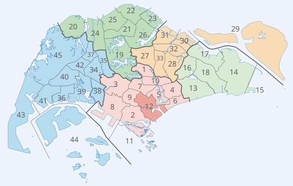
Suggested photograph: Historical map of Singapore’s planning areas based on Master Plan 2008, supplied as a high-resolution raster rendering.

Image link: https://upload.wikimedia.org/wikipedia/commons/thumb/c/c1/Singapore_MP2008._Urban_Planning_Areas.svg/3840px-Singapore_MP2008._Urban_Planning_Areas.svg.png

Suggested caption: Planning geography provides an organising framework, but current statutory interpretation requires the applicable plan, written provisions and amendments; this map is historical.

Credit: Bwonsamdi, Wikimedia Commons source, released into the public domain by its creator. Attribution is recommended; retain the historical date and do not present it as the current statutory plan.

Conclusion

India’s GIS-based master-planning initiative provides a practical basis for bringing spatial evidence into statutory planning. Its importance lies in the possibility of connecting development decisions with infrastructure capacity, environmental constraints and locally verified conditions.

The evidence reviewed establishes programme activity, database production, plan preparation and procurement. It does not establish that GIS-based planning has already caused better urban outcomes. That distinction should guide both public communication and future research.

The next evaluative step is to follow particular decisions: whether a proposed growth area changed after infrastructure analysis, whether a drainage connection was protected, whether an erroneous classification was corrected and whether investment followed the adopted plan.

AMRUT 2.0 should therefore be judged through the quality and use of its planning evidence, alongside the outcomes it helps achieve. A digital master plan becomes an institutional reform when authorities can maintain it, residents can interrogate it and decisions can be traced to defensible evidence. Without those conditions, greater cartographic precision can coexist with unchanged weaknesses in planning practice.

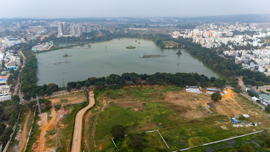
Suggested photograph: High-resolution aerial view of Attur Lake and the surrounding Bengaluru urban landscape.

Image link: https://upload.wikimedia.org/wikipedia/commons/thumb/4/45/Attur_Lake_Bengaluru_urban_lake_Karnataka_India_aerial_view.jpg/3840px-Attur_Lake_Bengaluru_urban_lake_Karnataka_India_aerial_view.jpg

Suggested caption: The ultimate test of geospatial planning is how evidence informs decisions about development, infrastructure and environmental systems, not the number of maps produced.

Credit: Vraj Acharya, WELL Labs, Wikimedia Commons source, CC BY-SA 4.0. Credit the photographer and organisation, link the licence, identify modifications and share adaptations under the same or a compatible licence.

References / Further Reading

Ministry of Housing and Urban Affairs. GIS-Based Urban Planning & Modernisation of Master Plans. Parliamentary reply, 10 August 2026.

Ministry of Housing and Urban Affairs. Sub-Scheme on Formulation of GIS-Based Master Plan for Class-II Towns with Population of 50,000–99,999 under AMRUT 2.0.

Ministry of Housing and Urban Affairs. AMRUT 2.0 Operational Guidelines.

Town and Country Planning Organisation. Sub-Scheme on Formulation of GIS-Based Master Plans for AMRUT Cities.

NITI Aayog. Reforms in Urban Planning Capacity in India.

National Remote Sensing Centre. Urban Applications.

National Remote Sensing Centre. Urban Water Information System.

Government of Kerala, Local Self Government Department. Re-Tender Notice: Formulation of GIS-Based Master Plans for AMRUT 2.0 Towns in Kerala.

AMRUT Kerala. Tender and Quotation Register.

Urban Redevelopment Authority, Singapore. Master Plan.

Related reading on Urban Design Lab: Free GIS Data Portals Every Architecture and Planning Student Should Know; 15th Finance Commission Urban Grants

Leave a Reply

Your email address will not be published. Required fields are marked *

This site uses Akismet to reduce spam. Learn how your comment data is processed.

Related articles

UDL Thesis Publication 2025

Call for Abstracts now open!

UDL GIS

MASTERCLASS

Urban Mapping, Analysis and Representation

Session Dates

12th-16th October, 2026

Curating the best graduate thesis projects globally!

Publish your work and get recognized globally!

Free E-Book

From thesis to Portfolio

A Guide to Convert Academic Work into a Professional Portfolio”

Urban Design Lab

Be the part of our Network

  • Stay updated on workshops, design tools, and calls for collaboration

  • Thesis Report Writing for Architecture and Urban Studies

    Join Our WhatsApp Group

    Recent Posts

    Sign up for our Newsletter

    “Let’s explore the new avenues of Urban environment together “

    E-Book- From Thesis To Portfolio

    A Guide to Convert Academic Work into a Professional Portfolio